Measuring and Mapping Earth - Real-life applications
Geologic Maps and Surveys
A geologic map shows the rocks beneath Earth's surface, including their distribution according to type as well as their ages, relationships, and structural features. The first geologic map, made in 1743, depicted subterranean East Kent, England. Its creator, the English physician and geologist Christopher Packe (1686-1749), introduced the technique of hachuring, that is, representing relief (elevation) on a map by shading in short lines in the direction of the slopes.
Three years later, the French geologist Jean-Etienne Guettard (1715-1786) made the first geologic map that crossed national lines, thus illustrating the distinction between geology and geography. As Guettard discovered, the geologic features of the French and English coasts along the English Channel are identical, indicating that the areas are connected. At a time when France and England were still bitter political and military rivals, Guettard's work showed that they literally shared some of the same land.
Geologic mapmaking received a further boost in 1815, when the English geologist William Smith (1769-1839) produced what has been called the first geologic map based on scientific principles. Entitled A Delineation of the Strata of England and Wales with Part of Scotland, the map used different colors to indicate layers of sedimentation. Roughly 6 ft. by 9 ft. (1.8 × 2.7 m), the map linked paleontology with stratigraphy (the study of fossils and the study of rock layers, respectively) and proved to be a milestone in geologic cartography.
MODERN GEOLOGIC MAPMAKING.
Geologic mapmaking changed considerably in the period after World War II. Before that time, geologists did most of their work with the use of topographical maps, or maps that showed only surface features. Following the war, however, aerial photography became much more common, giving rise to the technique of photogeology, the use of aerial photographic data to make determinations regarding the geologic characteristics of an area.
Petroleum companies, which often have taken the lead in developing advanced methods of geologic study, introduced the practice of creating three-dimensional images from the air.
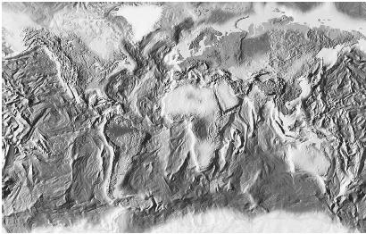
Of course, a great deal of work on the ground was still necessary for confirming the data revealed by aerial surveillance and for other purposes, such as measurement and sample collection. Nonetheless, aerial photography provided an enormous boost to geologic studies, as did the use of satellite imaging from the 1970s onward. Also helpful were such new devices as the handheld magnetometer, which made it relatively easy to separate rocks containing magnetite from other, nonmagnetic samples.
WHY MAKE GEOLOGIC MAPS?
One might wonder why any of this is important, aside from a purely academic interest in the structure of rocks under the ground. In fact, the need for precise geologic data goes far beyond "purely academic interests," as the reference to oil companies suggests. Geologic mapmaking is critical to the location of oil as well as minerals and other valuable natural resources—including the most useful one of all, water.
Likewise it is necessary to have accurate geologic information before undertaking a large engineering project, such as the building of a road or bridge. In such situations, geologic studies can quite literally be a matter of life and death, and eventually such studies may save more lives by aiding in the prediction of earthquakes or volcanoes. Geologic data is also a critical part of studies directed toward environmental protection, both for areas designed to remain natural habitats and for those designated for development. And, finally, there are studies whose purpose is purely, or mostly, academic but that reveal a great deal of useful information about the history of the planet, the forces that shaped it, and perhaps even future events.
GEOLOGIC SURVEYS.
Geologic mapmaking is so vital, in fact, that national governments have undertaken large-scale and ongoing geologic studies since 1835. That was the year that Great Britain became the first country to establish a geologic survey, with the aim of preparing a geologic map of the entire British Isles. The project began with the mapping of Cornwall and southern Wales and has continued ever since, with the addition of new details as they have become available.
In the ensuing years several other countries established their own geologic surveys, including the United States in 1889. (The Web site of the U.S. Geological Survey is listed in the bibliography.) Other important national geologic surveys include those of France, Canada, China, and Russia. The last of these surveys is of particular interest, dating as it does from the "Stone Department," a mineralogical survey established in 1584. Today even much smaller nations, such as Uruguay, Slovakia, and Namibia, have their own national geologic surveys.
Over the years, techniques of information gathering have evolved, particularly with the development of satellite remote-sensing technology. So, too, have the areas under the purview of various national geologic surveys, which since the 1950s have undertaken the mapping of the continental shelves adjacent to their own shorelines. (In addition, the nations claiming territories in Antarctica, including Britain and the United States, have mapped the geologic features of that continent extensively, though mining or other economic development there is forbidden.) The U.S. Geological Survey has also seen its scope extended to include studies on such issues as radioactive waste disposal and prediction of natural hazards, among them, earthquakes in urban areas.
Geophysical Measurements
Geophysics is a branch of the earth sciences that combines aspects of geology and physics. Among the areas it addresses are Earth's physical processes as well as its gravitational, magnetic, and electric properties and the means by which energy is transmitted through its interior. Areas of geophysics with a particular focus on measurement and mapping include the study of geomagnetism, or Earth's magnetic field, and geodesy, which is devoted to the measurement of Earth's shape and gravitational field.
The measurement of gravitational fields involves the use of either weights dropped in a vacuum or mechanical force-balance instruments. The first of these techniques is much older than the other and provides an absolute measure of the gravitational field in a given area. As for force-balance instruments, they are similar in principle to scales and furnish a relative measure of the gravitational field. To compare the gravitational field at different positions, however, it is necessary to establish a frame of reference. This is known as the geoid, a surface of uniform gravitational potential covering the entire earth at a height equal to sea level. (See Gravity and Geodesy for more on these topics.)
GEODETIC MEASUREMENTS OF EARTH'S SURFACE.
As noted, geodesy is concerned not only with Earth's gravitational field but also with its shape, and earth scientists working on this aspect of the subdiscipline employ many of the techniques and equipment described earlier with regard to geography and surveying. Eratosthenes's measurement of Earth's size is thought to be the first geodetic measurement, and in performing geodetic measurements today, earth scientists often employ concepts familiar to surveyors.
Among these concepts is triangulation, which was developed in the sixteenth century by the Dutch mathematician Gemma Frisius (1508-1555). Triangulation remained an important method of geodetic measurement until the development of satellite geodesy made possible simpler and more accurate measurements through remote sensing. Even today triangulation is still used by geologists without access to satellite data. In performing measurements using triangulation, geologists employ the theodolite, and typically at least one triangulation point is highly visible—for instance, the top of a mountain.
Until the 1950s scientists used a measuring tape of a material called Invar, a nickel-iron alloy noted for its tendency not to expand or contract with changes in temperature. From that time, however, electronic distance measurement (EDM) systems, which employ microwaves or visible light, came into use. EDM helped overcome some of the possibilities for error inherent in using any kind of tape, for example, the likelihood that it would sag and thus render incorrect measurements. Furthermore, EDM tended to reduce errors caused by atmospheric refraction.
With the advent of the United States program in the 1960s, increasingly more sophisticated forms of geodesic remote-sensing technology came into use. Among these techniques is satellite laser ranging, which relies on measurements of the amount of time required for a laser pulse to travel from a ground station to a satellite and back. Before the development of the global positioning system (GPS), discussed later, the use of satellite systems necessitated tracking through the Doppler effect, or the change in the observed frequency of a wave when the source of the wave is moving with respect to the observer. Thanks to GPS, put into operation by the U.S. Department of Defense, satellite tracking is much simpler and more accurate today.
GEOMAGNETIC MEASUREMENTS.
Ever since the ancient Chinese discovered that pieces of lodestone (magnetite) tend to point north, mariners have used the compass for navigation. The compass was augmented by other navigational devices until it was supplanted by the gyroscope in modern times and still later by more sophisticated devices and methods, such as GPS. Yet a compass still works fine for many a hiker, and its use serves to emphasize the importance of Earth's magnetic field.
Earth has an overall geomagnetic field, and specific areas on the planet have their own local magnetic fields. Thanks in large part to the contributions of Gauss, who developed a standardized local magnetic coordinate system in the early nineteenth century, it became possible to perform reasonably accurate measurements of local magnetic data while correcting for the influence of Earth's geomagnetic field. Indeed, one of the challenges in measuring magnetic fields is the fact that the Earth system possesses magnetic force from so many sources: the molten core, from whence originates the preponderance of Earth's magnetic field; external fields, such as the magnetosphere and ionosphere; local materials, such as magnetite, hematite, or pyrrhotite; and even man-made sources of magnetic or electric force.
After making calculations that correct for interfering sources of magnetism, geophysicists study the remaining magnetic anomalies, which can impart extremely valuable information. Classic examples include the discovery that Earth's magnetic polarity has reversed many times, a finding that led to the development of the geophysical subdiscipline known as paleomagnetism. Paleomagnetic studies, in turn, served as a highly significant confirmation of plate tectonics, which originated in the middle of the twentieth century and remains the dominant theory regarding geologic processes. (See Plate Tectonics. For more about geomagnetism, including some of the topics mentioned here, see Geomagnetism.)
Knowing One's Location
In these and other types of studies that involve mapping and measurement, it is important for scientists conducting surveys to be aware of the frame of reference from which they are operating—that is, the perspective from which they view data. Simply put, one must know first where one is before one can measure and map geophysical or other data for surrounding areas. This requires knowledge of latitude and longitude, or east-west and north-south positions, respectively.
From earliest times, mariners and scientists have been able to ascertain latitude with relative ease, simply by observing the angle of the Sun and other stars. Determination of longitude, however, proved much more difficult, because it required highly accurate timepieces. Only in the late eighteenth century, with the breakthroughs achieved by the British horologist John Harrison (1693-1776) did such calculations become possible. As a result, many a ship's crew was saved from the misfortunes that could result from inaccurate estimates of location.
GLOBAL POSITIONING SYSTEM.
By the latter part of the twentieth century, navigational technology had become vastly more sophisticated than it was in Harrison's day. From the 1957 launch of the Soviet satellite Sputnik 1, the skies over Earth became increasingly populated with satellites, such that within half a century dozens of countries had payloads in space. Aside from governments and scientific research establishments, even cable television companies used satellites to beam programming to homes all over the industrialized world, a fact that in itself says much about the spread of satellite technology.
Among the most impressive uses of satellites is the GPS, developed by the U.S. Department of Defense to assist in surveillance. GPS consists of 24 satellites orbiting at an altitude of 12,500 mi. (20,000 km). They move in orbital paths such that an earthbound receiver can obtain signals from four or more satellites at any given moment. On board are atomic clocks, which provide exact time data with each signal and eliminate the necessity of the receiver's having such an accurate clock. By receiving data from these satellites, persons on the ground can compute their own positions in terms of latitude and longitude as well as altitude. Not all receivers have access to the most accurate data possible: in line with the strategic mission for which it initiated GPS in the first place, the Defense Department ensures that only authorized personnel receive the most precise information.
Thus, GPS has built-in errors so that civilian users can calculate locations with an accuracy of "only" 328-492 ft. (100-150 m). This, of course, is amazingly accurate, but not as accurate as the data available to those authorized to receive normally encrypted information on the P (Precise) code. The latter provides an accuracy of 3.28-16.4 ft. (1-5 m) instantaneously, and more detailed measurements based on GPS data can be used to achieve accuracy of up to 0.2 in. (5 mm).
Remote Sensing
Many of the methods used by geologists and geophysicists to map and measure Earth make use of remote sensing, the gathering of data without actual contact with the materials or objects being studied. Without remote sensing, it would be impossible to discuss many physical phenomena intelligently, because it is unlikely that any technology ever will make it possible to explore many areas underneath the planet's surface directly.
An example of remote sensing is photogeology, described briefly earlier; so, too, is satellite imaging for data collection. The earth scientist of the twenty-first century likewise has other highly sophisticated forms of technology, such as radar systems or infrared imaging, at his or her disposal. As with many other aspects of geologic mapping and measurement, this one has value far beyond the classroom: remote-sensing studies make it possible, for instance, to observe the environmental impact of deforestation in large geographical areas. (For much more about this subject, see Remote Sensing.)
WHERE TO LEARN MORE
Brooks, Susan. The Geography of the Earth. New York: Oxford University Press, 1996.
Erickson, John. Exploring Earth from Space. Blue Ridge Summit, PA: TAB Books, 1989.
Geologic Maps (Web site). <http://http://www.aqd.nps.gov/grd/usgsnps/gmap/gmap1.html> .
Hancock, Paul L., and Brian J. Skinner. The Oxford Companion to the Earth. New York: Oxford University Press, 2000.
Internet Resources for Geography and Geology (Web site). <http://www.uwsp.edu/geo/internet/geog_geol_resources.html> .
Moffitt, Francis H., and Harry Bouchard. Surveying. 8th ed. New York: Harper and Row, 1987.
Remote Sensing Data and Information (Web site). <http://rsd.gsfc.nasa.gov/rsd/RemoteSensing.html> .
U.S. Geological Survey (Web site). <http://www.usgs.gov/> .
Virtual Museum of Surveying (Web site). <http://www.surveyhistory.org/index.htm> .
Wilford, John Noble. The Mapmakers. New York: Knopf, 2000.
Comment about this article, ask questions, or add new information about this topic: