Geomorphology - Real-life applications
Subsidence
Subsidence refers to the process of subsiding (settling or descending), on the part of either an air column or the solid earth, or, in the case of solid earth, to the resulting formation or depression. Subsidence in the atmosphere is discussed briefly in the entry Convection. Subsidence that occurs in the solid earth, known as geologic subsidence, is the settling or sinking by a body of rock or sediment. (The latter can be defined as material deposited at or near Earth's surface from a number of sources, most notably preexisting rock.)
As noted earlier, many geomorphologic processes can be caused either by nature or by human beings. An example of natural subsidence takes place in the aftermath of an earthquake, during which large areas of solid earth may simply drop by several feet. Another example can be observed at the top of a volcano some time after it has erupted, when it has expelled much of its material (i.e., magma) and, as a result, has collapsed.
Natural subsidence also may result from cave formation in places where underground water has worn away limestone. If the water erodes too much limestone, the ceiling of the cave will subside, usually forming a sinkhole at the surface. The sinkhole may fill with water, making a lake; the formation of such sinkholes in many spots throughout an area (whether the sinkholes become lakes or not), is known as karst topography.
In places where the bedrock is limestone—particularly in the sedimentary basins of rivers—karst topography is likely to develop. The United States contains the most extensive karst region in the world, including the Mammoth cave system in Kentucky. Karst topography is very pronounced in the hills of southern China, and karst landscapes have been a prominent feature of Chinese art for centuries. Other extensive karst regions can be found in southern France, Central America, Turkey, Ireland, and England.
MAN-MADE SUBSIDENCE.
Man-made subsidence often ensues from the removal of groundwater or fossil fuels, such as petroleum or coal. Groundwater removal can be perfectly safe, assuming the area experiences sufficient rainfall to replace, or recharge, the lost water. If recharging does not occur in the necessary proportions, however, the result will be the eventual collapse of the aquifer, a layer of rock that holds groundwater.
In so-called room-and-pillar coal mining, pillars, or vertical columns, of coal are left standing, while the areas around them are extracted. This method maintains the ceiling of the "room" that has been mined of its coal. After the mine is abandoned, however, the pillar eventually may experience so much stress that it breaks, leading to the collapse of the mined room. As when the ceiling of a cave collapses, the subsidence of a coal mine leaves a visible depression above ground.
Uplift
As its name implies, uplift describes a process and results opposite to those of subsidence. In uplift the surface of Earth rises, owing either to a decrease in downward force or to an increase in upward force. One of the most prominent examples of uplift is seen when plates collide, as when India careened into the southern edge of the Eurasian landmass some 55 million years ago. The result has been a string of mountain ranges, including the Himalayas, Karakoram Range, and Hindu Kush, that contain most of the world's tallest peaks.
Plates move at exceedingly slow speeds, but their mass is enormous. This means that their inertia (the tendency of a moving object to keep moving unless acted upon by an outside force) is likewise gargantuan in scale. Therefore, when plates collide, though they are moving at a rate equal to only a few inches a year, they will keep pushing into each other like two automobiles crumpling in a head-on collision. Whereas a car crash is over in a matter of seconds, however, the crumpling of continental masses takes place over hundreds of thousands of years.
When sea floor collides with sea floor, one of the plates likely will be pushed under by the other one, and, likewise, when sea floor collides with continental crust, the latter will push the sea floor under. (See Plate Tectonics for more about oceanic-oceanic and continental-oceanic collisions.) This results in the formation of volcanic mountains, such as the Andes of South America or the Cascades of the Pacific Northwest, or volcanic islands, such as those of Japan, Indonesia, or Alaska's Aleutian chain.
ISOSTATIC COMPENSATION.
In many other instances, collision, compression, and extension cause uplift. On the other hand, as noted, uplift may result from the removal of a weight. This occurs at the end of an ice age, when glaciers as thick as 1.9 mi. (3 km) melt, gradually removing a vast weight pressing down on the surface below.
This movement leads to what is called isostatic compensation, or isostatic rebound, as the crust pushes upward like a seat cushion rising after a person is longer sitting on it. Scandinavia is still experiencing uplift at a rate of about 0.5 in. (1 cm) per year as the after-effect of glacial melting from the last ice age. The latter ended some 10,000 years ago, but in geologic terms this is equivalent to a few minutes' time on the human scale.
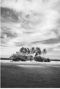
Islands
Geomorphology, as noted earlier, is concerned with landforms, such as mountains and volcanoes as well as larger ones, including islands and even continents. Islands present a particularly interesting area of geomorphologic study. In general, islands have certain specific characteristics in terms of their land structure and can be analyzed from the standpoint of the geosphere, but particular islands also have unique ecosystems, requiring an interdisciplinary study that draws on botany, zoology, and other subjects.
In addition, there is something about an island that has always appealed to the human imagination, as evidenced by the many myths, legends, and stories about islands. Some examples include Homer's Odyssey, in which the hero Odysseus visits various islands in his long wanderings; Thomas More's Utopia, describing an idealized island republic; Robinson Crusoe, by Daniel Defoe, in which the eponymous hero lives for many years on an island with no companion but the trusty native Friday; Treasure Island, by Robert Louis Stevenson, in which the island is the focus of a treasure hunt; and Mark Twain's Adventures of Huckleberry Finn, depicting Jackson Island in the Mississippi River, to which Huckleberry Finn flees to escape "civilization."
One of the favorite subjects of cartoonists is that of a castaway stranded on a desert island, a mound of sand with no more than a single tree. Movies, too, have long portrayed scenarios, from the idyllic to the brutal, that take place on islands, particularly deserted ones, a notable example being Cast Away (2000). A famous line by the English poet John Donne (1572-1631) warns that "no man is an island," implying that many wish they could enjoy the independence suggested by the concept of an island. Within the Earth system, however, nothing is fully independent, and, as we shall see, this is certainly the case where islands are concerned.
THE ISLANDS OF EARTH.
Earth has literally tens of thousands of islands. Just two archipelagos (island chains), those that make up the Philippines and Indonesia, include thousands of islands each. While there are just a few dozen notable islands on Earth, many more dot the planet's seas and oceans. The largest are these:
- Greenland (Danish, northern Atlantic): 839,999 sq. mi.(2,175,597 sq km)
- New Guinea (divided between Indonesia and Papua New Guinea, western Pacific): 316,615 sq. mi. (820,033 sq km)
- Borneo (divided between Indonesia and Malaysia, western Pacific): 286,914 sq. mi. (743,107 sq km)
- Madagascar (Malagasy Republic, western Indian Ocean): 226,657 sq. mi. (587,042 sq km)
- Baffin (Canadian, northern Atlantic): 183,810 sq. mi. (476,068 sq km)
- Sumatra (Indonesian, northeastern Indian Ocean): 182,859 sq. mi. (473,605 sq km)
The list could go on and on, but it stops at Sumatra because the next-largest island, Honshu (part of Japan), is less than half as large, at 88,925 sq. mi. (230,316 sq km). Clearly, not all islands are created equal, and though some are heavily populated or enjoy the status of independent nations (e.g., Great Britain at number eight or Cuba at number 15), they are not necessarily the largest. On the other hand, some of the largest are among the most sparsely populated.
Of the 32 largest islands in the world, more than a third are in the icy northern Atlantic and Arctic, with populations that are small or practically nonexistent. Greenland's population, for instance, was just over 59,000 in 1998, while that of Baffin Island was about 13,200. On both islands, then, each person has about 14 frozen sq. mi. (22 sq km) to himself or herself, making
CONTINENTS, OCEANS, AND ISLANDS.
Australia, of course, is not an island but a continent, a difference that is not related directly to size. If Australia were an island, it would be by far the largest. Australia is regarded as a continent, however, because it is one of the principal landmasses of the Indo-Australian plate, which is among a handful of major continental plates on Earth. Whereas continents are more or less permanent (though they have experienced considerable rearrangement over the eons), islands come and go, seldom lasting more than 10 million years. Erosion or rising sea levels remove islands, while volcanic explosions can create new ones, as when an eruption off the coast of Iceland resulted in the formation of an island, Surtsey, in 1963.
Islands are of two types, continental and oceanic. Continental islands are part of continental shelves (the submerged, sloping ledges of continents) and may be formed in one of two ways. Rising ocean waters either cover a coastal region, leaving only the tallest mountains exposed as islands or cut off part of a peninsula, which then becomes an island. Most of Earth's significant islands are continental and are easily spotted as such, because they lie at close proximity to continental landmasses. Many other continental islands are very small, however; examples include the barrier islands that line the East Coast of the United States. Formed from mainland sand brought to the coast by rivers, these are technically not continental islands, but they more clearly fit into that category than into the grouping of oceanic islands.
Oceanic islands, of which the Hawaiian-Emperor island chain and the Aleutians off the Alaskan coast are examples, form as a result of volcanic activity on the ocean floor. In most cases, there is a region of high volcanic activity, called a hot spot, beneath the plates, which move across the hot spot. This is the situation in Hawaii, and it explains why the volcanoes on the southern islands are still active while those to the north are not: the islands themselves are moving north across the hot spot. If two plates converge and one subducts (see Plate Tectonics for an explanation of this process), a deep trench with a parallel chain of volcanic islands may develop. Exemplified by the Aleutians, these chains are called island arcs.
ISLAND ECOSYSTEMS.
The ecosystem, or community of all living organisms, on islands can be unique owing to their separation from continents. The number of life-forms on an island is relatively small and can encompass some unusual circumstances compared with the larger ecosystems of continents. Ireland, for instance, has no native snakes, a fact "explained" by the legend that Saint Patrick drove them away. Hawaii and Iceland are also blessedly free of serpents.
Oceanic islands, of course, tend to have more unique ecosystems than do continental islands. The number of land-based animal life-forms is necessarily small, whereas the varieties of birds, flying insects, and surrounding marine life will be greater owing to those creatures' mobility across water. Vegetation is relatively varied, given the fact that winds, water currents, and birds may carry seeds.
Nonetheless, ecosystems of islands tend to be fairly delicate and can be upset by the human introduction of new predators (e.g., dogs) or new creatures to consume plant life (e.g., sheep). These changes sometimes can have disastrous effects on the overall balance of life on islands. Overgrazing may even open up the possibility of erosion, which has the potential of bringing an end to an island's life.
WHERE TO LEARN MORE
Color Landform Atlas of the United States (Web site). <http://fermi.jhuapl.edu/states/states.html> .
Erickson, Jon. Rock Formations and Unusual Geologic Structures: Exploring the Earth's Surface. New York: Facts on File, 1993.
Erickson, Jon. Making the Earth: Geologic Forces That Shape Our Planet. New York: Facts on File, 2000.
Gerrard, John. Rocks and Landforms. Boston: Unwin Hyman, 1988.
Image Gallery of Landforms (Web site). <http://www.athena.ivv.nasa.gov/curric/land/landform/landform.html> .
Selby, Michael John. Earth's Changing Surface: An Introduction to Geomorphology. New York: Clarendon Press, 1985.
Tinkler, K. J. A Short History of Geomorphology. Totowa, NJ: Barnes and Noble, 1985.
The Virtual Geomorphology (Web site). <http://main.amu.edu.pl/~sgp/gw/gw.htm> .
Wells, Lisa. "Images Illustrating Principles of Geomorphology" (Web site). <http://geoimages.berkeley.edu/GeoImages/Wells/wells.html> .
Zoehfeld, Kathleen Weidner, and James Graham Hale. How Mountains Are Made. New York: HarperCollins, 1995.
Comment about this article, ask questions, or add new information about this topic: