The Hydrologic Cycle - Real-life applications
The Life of a Water Droplet
Now let us follow the progress of a single water droplet as it passes through the water cycle. This particular droplet, like all others, has passed through the cycle countless times over the course of the past few billion years, and in its various incarnations it has existed as groundwater, as moisture in the atmosphere, and as ice.
For the short span of Earth's existence that humans have occupied the planet, it is conceivable that our droplet has been consumed—either directly, as liquid water, or indirectly, as part of the water content in animal or vegetable material. That would mean that it also has been excreted, after which it will have continued the cycle of circulation. In theory, it might well be part of the water in which humans bathe, brush their teeth, or wash their clothes.
WATER AND FOREIGN MATERIAL.
Of course, personal hygiene as we know it today is an extremely recent development: for instance, regular toothbrushing as a practice among the whole population began in the United States only around the turn of the nineteenth century. Still, it is a bit disconcerting to think that the water in which we brush our teeth today may have floated down a sewer pipe at another time. Nonetheless, by moving water through so many locales, the hydrologic cycle has a built-in cleansing component.
This cleansing component can be illustrated by the experience of saltwater, which despite its presence in the ocean is actually a small portion of Earth's total water supply. The reason is that the salt seldom travels with the water; as soon as the water evaporates, the salt is left behind. This is why people on the proverbial desert island or in other survival situations use evaporation to make saltwater drinkable.
Likewise, saltwater as such cannot survive the transition from liquid water to ice: as the water freezes, the ice (which has a much lower freezing point) simply is precipitated and left behind. Just as salt does not travel with water as it makes its way through the various stages of the hydrologic cycle, so other varieties of foreign matter are left behind as well; as long as water is not allowed to stagnate, it usually is cleansed in the course of traveling between the ground and the atmosphere.
This is not to say that water typically exists in a pure form. Often called the universal solvent, water has such a capacity to absorb other substances that it is unlikely ever to appear in pure form unless it is distilled under laboratory conditions. Water in mountain streams, for instance, absorbs fragments of rock as it travels downhill, slowly eroding the surrounding rock and soil.
From the Watershed to Points Beyond
On a particular watershed—an area of terrain from which water flows into a stream, river, or lake—our hypothetical water droplet may enter from a number of directions. In the simplest model of water flow, it comes from precipitation, including rain, snow, or even mist from clouds. The water has to go somewhere, and it may go either up or down. It may return to the atmosphere as evapotranspiration; it may enter the ground; or, if it reaches the solid earth at some elevation above sea level, it may enter a stream and flow ultimately to the ocean.
For water to enter the atmosphere generally requires an extensive surface area of vegetation, which supports high rates of transpiration. This transpiration, combined with evaporation from such inorganic surfaces as moist soil or bodies of water, puts a great deal of water into the atmosphere. Without significant evapotranspiration, however, it is necessary for the water to drain from the watershed, either as seepage to deep groundwater or as flow in the form of a stream.
THE FIVE STAGES OF THE HYDROLOGIC CYCLE.
The overall process of the hydrologic cycle can be divided into five parts: condensation, precipitation, infiltration,
Infiltration can be great or small, depending on the permeability of the ground. The soil of a rainforest, for instance, has so much organic matter that it is likely to be highly permeable. On the other hand, cities have large amounts of what land developers call impervious surface: roads, buildings, and other areas in which concrete and other materials prevent water from infiltrating the ground.
Assuming that water is unable to infiltrate, it becomes runoff. Runoff is simply surface water, which may take the form of streams, rivers, lakes, and oceans. If runoff occurs in an area that is not already a body of water, flood conditions may ensue. Thus, water may either infiltrate or become runoff, but as long as it remains close to the surface, it will experience evaporation.
In evaporation energy from the Sun changes liquid water into gaseous form, transporting it as a vapor into the atmosphere. Thus, the water is returned to the air, where it condenses and resumes the cycle we have described. As noted earlier, the water on or near Earth's surface is a small portion of the total. What about ground-water far below the surface? Let us now examine a particularly notable example of an aquifer, or groundwater reservoir.
The Ogallala Aquifer
Located beneath the central United States, the Ogallala Aquifer provides a vast store of ground-water that supports a large portion of American agriculture. The Ogallala, also known as the High Plains Regional Aquifer, was discovered in the early years of the nineteenth century. It did not become a truly significant economic resource, however, until the second half of the twentieth century, when advanced pumping technology made possible large-scale irrigation from the aquifer's supplies. By 1980 the Ogallala supported some 170,000 wells and accounted for fully one-third of all water used for irrigation purposes in the United States.
Centered in Nebraska, the aquifer underlies parts of seven other states: South Dakota, Wyoming, Colorado, Kansas, Oklahoma, Texas, and New Mexico. It stretches 800 mi. (1,287 km) from north to south and 200 mi. (322 km) from east to west at its widest point. All told, the Ogallala covers some 175,000 sq. mi. (453,250 sq km), an area larger than Germany—all of it underground.
In Nebraska, the aquifer is between 400 ft. and 1,200 ft. (130-400 m) deep, while at the southern edges its depth extends no more than 100 ft. (30 m). Composed of porous sand, silt, and clay formations deposited by wind and water from the Rocky Mountains, the Ogallala is made up of several sections, called formations. The largest of these is the Ogallala formation, which accounts for about 77% of its total volume.
USING UP THE OGALLALA.
The Ogallala is particularly important to local agriculture because the states that it serves are home to numerous dry areas. Yet high-volume pumping of the underground reserves has reduced the available groundwater, much as the pumping of oil gradually is consuming Earth's fossil-fuel reserves. Indeed, the water of the Ogallala is known as fossil water, meaning that it has been stored underground for millions of years, just as the coal, oil, and gas that runs modern industrial civilization has.
Of course, the water from the Ogallala is not simply used up in an irreversible process, as is the case with fossil fuels; nonetheless, the rapidly accelerating reduction of its water supplies is cause for some alarm. Less than 0.5% of the water removed from this aquifer is being returned to the ground, and if the current rate of pumping increases, the supplies will be 80% depleted by 2020.
The consequences of this depletion are already being felt in Kansas, where streams and rivers, dependent on groundwater to feed their flow, are running dry. In that state alone, more than 700 mi. (1,126 km) of rivers that formerly flowed year-round have been reduced to dry channels. In New Mexico and Texas, use of center-pivot irrigation, which requires a well capable of pumping 750 gal. (2,839 l) per minute, is disappearing because the local aquifer can no longer sustain such volumes.
In addition to the problem of diminishing supplies, contamination is an issue. As more and more agricultural chemicals seep into an ever shrinking reservoir, the towns of the high plains—places once known for their pure, clean groundwater—now have tap water that is considered unsafe for children and pregnant women. Overuse of the Ogallala is also exacting a financial toll, as more and more wells run dry and farms go bankrupt.
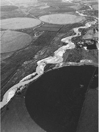
Rivers
Despite the environmental challenges posed by such situations as the exhaustion of the Ogallala, the hydrologic cycle continues to roll on. As it does, it is sustained in large part by processes we cannot see: the movement of groundwater from the aquifer into streams or the evapotranspiration of surface waters to the atmosphere. Yet the movement of waters along the surface, because it is visible and recognizable to humans, attractshuman attention in a way that many of theseother components of the hydrologic cycle do not.
Rivers and other forms of surface water actually account for a relatively small portion of the planet's water supply, but they loom large in the human imagination as the result of their impact on our lives. The first human civilizations developed along rivers in Egypt, Mesopotamia, India, and China, and today many a great city lies along a river. Rivers provide us with a means of transportation and recreation, with hydroelectric power, and even—after the river water has been treated—with water for drinking and bathing.
FORMATION OF RIVERS.
Rivers usually form from tributaries, such as springs. As the river flows, it is fed by more tributaries and by groundwater and continues on its way at various speeds, depending on the terrain. Finally, the river discharges into an ocean, a lake, or a desert basin.
River waters typically begin with precipitation, whether in the form of rainwater or melting snow. They also are fed by groundwater exuding from bedrock to the surface. When precipitation falls on ground that is either steeply sloped or already saturated, the runoff moves along Earth's surface, initially in an even, paper-thin sheet. As it goes along, however, it begins to form parallel rills, and its flow becomes turbulent. As the rills pass over fine soil or silt, they dig shallow channels, or runnels.
At some point in their flow, the runnels merge with one another, until there are enough of them to form a stream. Once enough streams have converged to create a continuously flowing body of water, it becomes a brook, and once the volume of water carried reaches a certain level, the brook becomes a river. As we have already noted, however, a river is really the sum of its tributaries, and thus hydrologists speak of river systems rather than single rivers.
RIVER SYSTEMS.
A particularly impressive example of a river system is the vast Mississippi-Missouri, which drains the central United States. Most of the rivers between the Rockies and the Appalachians that do not empty directly into the Gulf of Mexico feed this system. This system includes the Ohio, itself an impressive river that divides the eastern United States. Indeed, just as the Mississippi separates east from west in America, the Ohio separates north from south.
After the Ohio and the Mississippi converge, at the spot where Illinois, Missouri, and Kentucky meet, they retain their separate identities for many miles. A strip of clear water runs along the river's eastern side, while to the west of this strip the water is a cloudy yellow—indicating a heavier amount of sediment in the Mississippi than in the Ohio. A similar phenomenon occurs where the "Blue Nile" and "White Nile," tributaries of another great river—both named for the appearance of the water—meet at Khartoum in Sudan.
WHERE TO LEARN MORE
"Groundwater Primer: Hydrologic Cycle." U.S. Environmental Protection Agency (Web site). <http://www.epa.gov/seahome/groundwater/src/cycle.htm> .
Hamilton, Kersten. This Is the Ocean. Honesdale, PA: Caroline House/Boyds Mills Press, 2001.
"Hydrologic Cycle." The Groundwater Foundation (Web site). <http://www.groundwater.org/GWBasics/hydro.htm> .
The Hydrologic Cycle (Web site). <http://agen521.www.ecn.purdue.edu/AGEN521/icon.html> .
Hydrologic/Water Cycle (Web site). <http://www.und.nodak.edu/instruct/eng/fkarner/pages/cycle.htm> .
Pidwirny, Michael J. "Introduction to Hydrology: The Hydrologic Cycle." Fundamentals of Physical Geography (Web site). <http://www.geog.ouc.bc.ca/physgeog/contents/8b.html> .
Richardson, Joy. The Water Cycle. Illus. Linda Costello. New York: F. Watts, 1992.
Smith, David. The Water Cycle. Illus. John Yates. New York: Thomson Learning, 1993.
Schaefer, Lola M. This Is the Ocean. Illus. Jane Wattenberg. New York: Greenwillow Books, 2001.
Walker, Sally M. Water Up, Water Down: The Hydrologic Cycle. Minneapolis: Carolrhoda Books, 1992.
Comment about this article, ask questions, or add new information about this topic: