Plain
The topography or surface area of the world's continents varies greatly, with features ranging from mountains and other highland areas to plunging canyons and low-lying basins. Despite this diversity of landforms, certain large-scale features are common to all continents. Generally, the continents contain vast interior plains that make up over 50 percent of their landscape. Plains are also found along certain coasts of continents and on the ocean floor.
Plains may seem common and unremarkable, lacking the grand character of mountains or the mysteriousness of caves. Yet these normally flat landforms have a rich geological history, offering an insight into the forces that have helped shape the surface of the planet.
The shape of the land
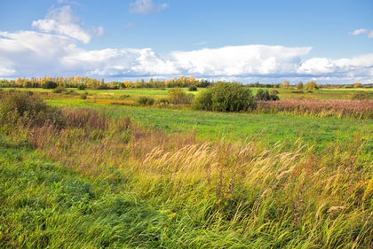
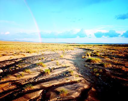
A plain may be defined broadly as any lowland area that is level or gently sloping or rolling. It normally has few, if any, prominent hills or valleys, but may have considerable slope. A plain may be forested or bare of trees. Many plains around the world are covered in grasses. A plain may be as small as several hundred square feet or as large as hundreds of thousands of square miles.
A plateau is another landform that is relatively level, and some sources claim that a plateau is an elevated plain. A plateau has at least one steep, clifflike side. It forms as a result of geologic uplift (the slow upward movement of large parts of stable areas of Earth's crust due to heat forces within the planet) or as a result of many lava flows that spread out over hundreds of thousands of square miles. These flows, which build up the land surface, form plateaus known as lava or basalt plateaus because basalt is the dark, dense volcanic rock that forms these particular lava flows. (For further information, see the Plateau chapter.)
There are significant differences between a plateau and a plain. A plain has no steep sides, but sits at a low elevation relative to its surrounding landscape. It experiences no uplift. In fact, the heat forces within Earth, the actions of which have led to the formation of mountains, volcanoes, and plateaus, have played no direct role in the formation of plains. Those forces have broken Earth's crust (the thin, solid, outermost layer of the planet) and uppermost mantle (the region of the planet just below the crust) into sections or plates. The movement of the plates across the surface of the planet in response to the pressure exerted by those heat forces is known as tectonic activity (pronounced tek-TAH-nik; from the Greek word tekton , meaning "builder"). In contrast, plains are areas that are not tectonically active, but are quite stable.
Plains are formed primarily by erosion and the deposition of sediment. Erosion is the gradual wearing away of Earth surfaces through the action of wind and water. Sediment is rock debris such as clay, silt, sand, and gravel (or even larger material) that is being carried from its place of origin or has already been deposited on Earth's surface by wind, water, or ice.
Plains found on the interior of continents are known generally as interior or continental plains; those found along coasts are coastal plains. Interior plains are frequently bounded on one or more sides by mountain ranges. Coastal plains, which cover less than 1 percent of the planet's total land area, generally rise from sea level until they meet higher landforms such as plateaus or mountain ranges. Some form narrow strips along coasts; others extend hundreds of miles inland. The imaginary line that marks the sharp upward slope of land along a coastal plain's inland edge where waterfalls and rapids occur as rivers cross the zone from harder to softer rocks is called the fall line. Some geologists now consider that term to be obsolete because materials that compose coastal plains are often found inland beyond that point.
Plain: Words to Know
- Abyssal plain:
- The relatively flat area of an ocean basin between a continental margin and a mid-ocean ridge.
- Alluvial fan:
- A fanlike deposit of sediment that forms where an intermittent, yet rapidly flowing canyon or mountain stream spills out onto a plain or relatively flat valley.
- Alluvium:
- The general term for sediment (rock debris such as gravel, sand, silt, and clay) deposited by running water.
- Coastal plain:
- A low, generally broad plain that lies between an oceanic shore and a higher landform such as a plateau or a mountain range.
- Erosion:
- The gradual wearing away of Earth surfaces through the action of wind and water.
- Fall line:
- The imaginary line that marks the sharp upward slope of land along a coastal plain's inland edge where waterfalls and rapids occur as rivers cross the zone from harder to softer rocks.
- Floodplain:
- An area of nearly flat land bordering a stream or river that is naturally subject to periodic flooding.
- Glacier:
- A large body of ice that formed on land from the compaction and recrystallization of snow, survives year to year, and shows some sign of movement downhill due to gravity.
- Peneplain:
- A broad, low, almost featureless surface allegedly created by long-continued erosion.
- Sedimentary rock:
- Rock that is formed by the accumulation and compression of sediment, which may consist of rock fragments, remains of microscopic organisms, and minerals.
Smaller-scale, level features formed by erosion and deposition are also labeled as plains. Glaciers, large bodies of ice that formed on land from the compaction and recrystallization of snow and survive year to year, deposit large amounts of sediment at their leading edges. This sediment forms broad, sweeping plains called outwash plains. (For further information on glaciers and their actions, see the Glacial landforms and features chapter.) Streams and rivers that periodically overflow the banks of their channels deposit sediment they are carrying on the surrounding landscape, creating floodplains. The general term for sediment deposited by running water is alluvium (pronounced ah-LOO-vee-em). Because floodplains are covered with alluvium, they are often called alluvial plains. Some sources use the term alluvial plain to describe any plain built up by sediments deposited by streams or sheets of running water. (For further information, see the Floodplain chapter.)
Abyssal (pronounced ah-BISS-ul) plains are relatively flat areas of ocean basins, which are that part of Earth's surface that extends seaward from the continental margins, the submerged outer edges of the continents. With gentle slopes of less than 1 foot (0.3 meter) of elevation difference for each 1,000 feet (305 meters) of distance, abyssal plains are far flatter than any plains on dry land. (For further information, see the Ocean basin chapter.)
A peneplain (pronounced PEE-nah-plane) is a broad, low, almost featureless surface allegedly created by long-continued erosion, which may include the action of glaciers or streams. Some sources state that peneplains descended from landforms that were originally rugged or much higher, such as plateaus or ancient mountains. These relatively flat surfaces are end products of the land surface after, supposedly, millions of years of erosion. This concept is troubling to many geologists, and the idea behind the formation of peneplains remains hotly debated.
Some sources incorrectly state that tundras, steppes, prairies, pampas, savannas, and llanos (pronounced YAH-nos) are plains. A plain is a landform; all of the others are biomes, which are distinct, natural communities chiefly distinguished by their plant life and climate. The confusion may be due to the fact that these biomes commonly cover plains.
Forces and changes: Construction and destruction
Fluvius is the Latin word meaning "river." Fluvial (pronounced FLEW-vee-ul) landforms are those shaped and created by running water. Because streams and other forms of running water are present in almost all landscapes, even if only occasionally, fluvial landforms dominate Earth's land surface. A highly effective means of erosion and transportation, running water carries billions of tons of sediment across the surface of the planet. Over a 1,000-year period, this is enough to lower land surfaces by an average of 1.3 inches (3.3 centimeters). It is a rate ample enough to level all continental land surfaces to a flat, featureless landscape in 25 million years.
The action of running water
Surging over a landscape, water picks up and transports as much material from the surface as it can carry. Gravity and steep slopes aid rushing water in carrying increasingly larger and heavier objects. Erosion by water begins as soon as raindrops hit the ground and loosen small particles. During heavy rains, sheets of water flow over the ground, loosening and picking up even more particles. This water quickly concentrates into channels, which then become streams that flow into rivers.
The amount and size of the material that running water can transport depends on the velocity or speed of that water. A fast-moving stream, for example, carries more sediment and larger material than a slow-moving one. A stream that is turbulent or agitated can also lift and carry more rocks and sediment than one that flows gently.
Running water will continue to carry its load of sediment as long as its velocity remains constant or increases (if it increases, it can carry an even larger load). Any change in the geography of the landscape that causes a water channel to bend or rise will slow the flow of the water. If running water loses speed, it loses the ability to carry its entire load and a portion will be deposited, depending on how much it slows down. Particles will be deposited by size with the largest settling out first and the finest deposited last.
This is what occurs when streams and rivers overflow their banks to form floodplains. The water immediately loses velocity, and its load of sediment is deposited. As is always the case, larger particles drop out first, while finer-grained silts and clays are carried farther away from the stream or river channel.
Running water in high elevation areas, such as mountain ranges, flows rapidly down to lower-lying areas through canyons, valleys, and other narrow, confined channels. If the surface over which the water flows lacks plants and other ground cover, the rushing water easily picks up any loose material in its path.
The Literary Landscape
"On this continent and in the psyche of its peoples the plains have always been a staggering presence, a place of myth and cliche, a place for transformation, bafflement, or heartbreak. From the east they are release from the clawing of swamp and tangle and human density. From the west they are a drop and a straightening after the kinks and strains of mountains. Entered from any direction they are new air, a joy to behold, a combination of large-scale intimidation and primordial inner acoustics.
—Merrill Gilfillan, Magpie Rising: Sketches from the Great Plains , 1988.
When it finally reaches a lowland area, the running water loses power since gravity is no longer helping it flow down a steep slope. Slowing, the water is unable to carry the sediment it picked up on its way downhill. No longer confined to a narrow channel, the water spreads out the farther it moves away from the base of the mountain range. Large rocks and other heavy material are deposited first, followed by other material in decreasing size to form a fanlike deposit on the floor of the lowland. This deposit is known as an alluvial (pronounced ah-LOO-vee-al) fan.
Given time, as more water flows out, more sediment is deposited, and fans begin to merge with other fans. Over spans of millions of years, layer upon layer of sediment forms, spreading to cover thousands or hundreds of thousands of square miles, filling valleys, covering low hills, and leveling the land to form vast interior plains.
It is important to note that many interior plains, such as the Great Plains in the central United States, were once covered by ancient oceans and seas. As marine life perished, the remains settled to the bottom, where, over millions of years, they formed sedimentary rock (rock formed by the accumulation and compression of sediment, which may consist of rock fragments, remains of microscopic organisms, and minerals). When the waters receded, flat-lying layers of sedimentary rock remained, providing a somewhat level base for the further accumulation of sediment from nearby highland areas.
Coastal plains
Coastal plains are similarly covered by layers of sediment, these laid down by seaward-flowing streams from inland highland areas. Many coastal plains have a terraced landscape that stair-steps down to the coast. These gradually rising stairs are former shorelines and portions of sea bottom that emerged to become land. This landscape was formed over the last few million years as sea levels rose and fell in response to the repeated melting and growth of large continental glaciers. The weight of these immense glaciers also depressed land along coasts below sea level. When global temperatures rose and glaciers retreated, the land "rebounded," rising once again above sea level.
As continental glaciers lumbered across the landscape, they scoured away material underneath them, eroding and leveling the surface. They also plucked up rocks and other material, some of which were house-sized boulders. When the glaciers began to melt and retreat, they produced meltwater that flowed on top, within, and underneath the glaciers through channels. This meltwater moved large quantities of sediment from the glaciers. At the leading edges of the glaciers, the meltwater emerged in rapidly flowing, broad streams that surged away from the glaciers. The sediment in the meltwater was then deposited, forming outwash plains. Characteristically flat or gently rolling, outwash plains consist of layers of sand and other finely crushed sediments.
Spotlight on famous forms
Atlantic-Gulf Coastal Plain, United States
The Atlantic-Gulf Coastal Plain stretches over 3,200 miles (5,150 kilometers) in length from Cape Cod to Mexico. It is the world's largest
coastal plain, and it covers approximately 583,000 square miles (1,509,970 square kilometers). The coastal plain is divided into two regions in the United States. The Atlantic Coastal Plain stretches south from Cape Cod and the islands off southeast Massachusetts through New York, New Jersey, Delaware, Maryland, Virginia, North Carolina, South Carolina, Georgia, and Florida. Rounding Florida, it becomes the Gulf Coastal Plain, which continues through Alabama, Mississippi, Louisiana, Texas, and into Mexico.
The plain is narrow in New England but reaches a maximum width of about 200 miles (322 kilometers) farther south. While its terrain is mostly flat, it does slope gently seaward from the inland highlands in a series of terraces or ridges and low hills. This gentle slope continues far into the Atlantic Ocean and the Gulf of Mexico, forming the upper region of the continental margin, the submerged outer edge of the continent.
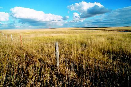
Great Plains, United States
The Great Plains form an extensive grassland region in central North America. They stretch from the Canadian provinces of Alberta, Saskatchewan, and Manitoba south into Montana, North Dakota, South Dakota, Wyoming, Colorado, Nebraska, Kansas, Oklahoma, New Mexico, and northern Texas. They cover an area of about 450,000 square miles (1,165,500 square kilometers).
More than 65 million years ago, much of the present-day Great Plains was covered by a vast inland sea. Marine sediments that were deposited make up the nearly horizontal rock structure that underlies the area. When the Rocky Mountains began rising and the sea retreated, streams and rivers began to wash enormous amounts of sediment from the mountains over the plains. Currently, the plains slope gently eastward from that great mountain system at an elevation of 6,000 feet (1,829 meters). Where they merge into the interior lowlands, they stand at an elevation of approximately 1,500 feet (457 meters). The average eastward slope is roughly 10 feet per mile (1.9 meters per kilometer).
Glaciers from the last Ice Age left thick layers of sediment and other features that mark the landscape in the northern section of the Great Plains. In some places, the sediment measures to depths of hundreds of feet.
Although much of the terrain of the Great Plains is flat or gently rolling, several topographical features rise significantly above the plains. Prominent among these are the Black Hills of South Dakota and Wyoming, formed by an upwelling of magma under Earth's crust. They are one of the few indications of tectonic activity in this entire region.
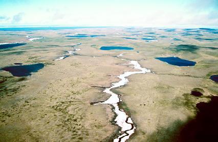
West Siberian Plain, Russia
One of the world's largest regions of continuous flatland is found in central Russia. The West Siberian Plain lies between the Ural Mountains in the west and the Yenisey River Valley in the east. The Kara Sea bounds it in the north, while the Torghay Plateau, the Kazak Uplands, and the Altai Mountains mark its southern border. It stretches over a region nearly 1,100 miles (1,770 kilometers) wide, covering approximately 1.2 million square miles (3.1 million square kilometers).
Formed by glacial deposits after the last Ice Age, which ended approximately 10,000 years ago, the plain is exceedingly flat and featureless. Only occasional low hills and ridges, the remains of glacial action, punctuate the landscape. The plain has very poor drainage, resulting in vast swampy areas. The Vasyugan Swamp, in the center of the plain, covers 18,500 square miles (47,915 square kilometers). The northern section of the plain is mostly barren tundra.
For More Information
Web Sites
"Atlantic Plain Province." U.S. Geological Survey and the National Park Service . http://wrgis.wr.usgs.gov/docs/parks/province/atlantpl.html (accessed on August 6, 2003).
"The Great Plains and Prairies." U.S. Department of State . http://usinfo.state.gov/products/pubs/geography/geog11.htm (accessed on August 6, 2003).
"Interior Plains Province." U.S. Geological Survey and the National Park Service . http://wrgis.wr.usgs.gov/docs/parks/province/intplain.html (accessed on August 6, 2003).
Trimble, Donald E. "The Geologic Story of the Great Plains." North Dakota State University Libraries . http://www.lib.ndsu.nodak.edu/govdocs/text/greatplains/text.html (accessed on August 6, 2003).