Stream and river
Flowing water, in streams and rivers or across the land in sheets, is the dominant erosional process in shaping Earth's landscape. Streams and rivers are not merely systems for moving surface water to the world's oceans and seas. They are also systems for moving weathered rocks and other sediment to those large bodies of water. In fact, it is estimated that streams and rivers move about 1.65 billion tons (1.5 billion metric tons) of sediment from land to the oceans each year. By shifting such great masses of sediment, streams and rivers become sculptors of the land.
Streams and rivers erode, transport sediment, change course, and flood their banks in natural and recurring patterns. It is true that most of the erosional work done by surface water is not done by streams or rivers but instead by falling raindrops and by the resulting unorganized runoff down slopes. Yet streams and rivers are able to create both erosional landforms (their own channels, canyons, and valleys) and depositional landforms (floodplains, alluvial fans, and deltas) as they flow over Earth's surface.
The shape of the land
Geologists define a stream as any body of running water that moves downslope under the influence of gravity in a narrow and defined channel on Earth's surface. Streams are also found on the ground surface in caves and underneath and inside glaciers (large bodies of ice that formed on land by the compaction and recrystallization of snow and that survive year to year). Rivers, creeks, brooks, and runs are all streams. Most sources define a river simply as a large stream; creeks, brooks, and runs are simply small streams. For this discussion, stream will be used to refer to all of these bodies of running water.
When water flows down a slope, it tends to gather in small depressions on the surface along the way. This concentration of moving water stimulates the process of erosion, which is the gradual wearing away of Earth surfaces through the action of wind and water. As the water erodes rock and other material in the depression, it forms a channel. The stream channel is the landform, not the water carried in it. The sides of the channel are known as the stream's banks. The bottom is the stream bed.
A stream's velocity, or speed, determines its ability to erode, transport, and deposit sediment. Sediment is rock debris such as clay, silt, sand, gravel, or even larger material. Alluvium (pronounced ah-LOO-vee-em) is the general term for sediment deposited by running water. A fast-moving stream carries more sediment and larger material than a slow-moving one. A stream that is turbulent, with water whirling through the channel and not flowing in a steady and straight manner, can also lift and carry more rocks and sediment than one that flows gently. Turbulence is due to the friction caused by rocks and steps in the stream's channel.
Stream and river: Words to Know
- Alluvial fan:
- A fanlike deposit of sediment that forms where an intermittent, yet rapidly flowing, canyon or mountain stream spills out onto a plain or relatively flat valley.
- Alluvium:
- The general term for sediment (rock debris such as gravel, sand, silt, and clay) deposited by running water.
- Base level:
- The level below which a stream cannot erode.
- Bed load:
- The coarse sediment rolled along the bottom of a stream.
- Channel:
- The depression where a stream flows or may flow.
- Cut bank:
- A steep, bare slope formed on the outside of a meander.
- Delta:
- A body of sediment deposited at the mouth of a stream where it enters an ocean or a lake.
- Dissolved load:
- Dissolved substances, the result of the chemical weathering of rock, that are carried along in a stream.
- Distributaries:
- The channels that branch off of the main stream in a delta, carrying water and sediment to the delta's edges.
- Erosion:
- The gradual wearing away of Earth surfaces through the action of wind and water.
- Floodplain:
- An area of nearly flat land bordering a stream that is naturally subject to periodic flooding.
- Graded stream:
- A stream that is maintaining a balance between the processes of erosion and deposition.
- Groundwater:
- Freshwater lying within the uppermost parts of Earth's crust, filling the pore spaces in soil and fractured rock.
- Levee (natural):
- A low ridge or mound along a stream bank, formed by deposits left when floodwater slows down on leaving the channel.
- Meander:
- A bend or loop in a stream's course.
- Oxbow lake:
- A crescent-shaped body of water formed from a single loop that was cut off from a meandering stream.
- Point bar:
- The low, crescent-shaped deposit of sediment on the inside of a meander.
- Rapids:
- The section of a stream where water flows fast over hard rocks.
- River:
- A large stream.
- Stream:
- Any body of running water that moves downslope under the influence of gravity in a defined channel on Earth's surface.
- Suspended load:
- The fine-grained sediment that is suspended in the flow of water in a stream.
- Waterfall:
- A steep drop in a stream bed causing the water in a stream channel to fall vertically or nearly vertically.
Factors that influence the velocity of a stream include its gradient (slope of its channel), the amount of sediment it carries, the shape of its channel, and its discharge (volume of water flowing past a given point over a given period of time). A low gradient, a high amount of sediment, a rough channel (both bed and banks), and a low discharge will all slow the velocity of a stream.
A stream's load is the total amount of sediment it is carrying. The sediment load consists mainly of two parts. The first part is the coarse material such as sand and gravel that moves along the stream bed. This is known as the bed load. As it is carried along, this coarse sediment acts as an abrasive, scouring and wearing away the banks and bed of the stream. The stream then picks up any newly loosened and eroded material. The second part is the fine-grained material such as clay and silt that is suspended in the water as the stream flows along. This is the suspended load. Streams also carry a dissolved load. These dissolved substances are the result of the chemical weathering of rock, which alters the internal structure of minerals by removing or adding elements.
Stream channels
There are three types of stream channels: straight, meandering, and braided. Although there are no absolutely straight channels in nature, geologists refer to straight channels as those that are relatively straight with little lateral or side-to-side movement. They are typically found in the headlands, or area where the stream begins, usually a highland or mountainous region. They are also found following an underlying weak rock layer in an area, such as along a fault or a joint (a fault is a crack or fracture in Earth's crust along which rock on one side has moved relative to rock on the other; when no movement has occurred, the fracture is known as a joint). The velocity of the water in a straight channel is fast because the channel often has a steep gradient. Its discharge is also high. The channel is often deeper than it is wide, and most erosion occurs along the stream bed, although its sediment load is not yet large.
Meandering stream channels are quite common. In fact, virtually all flowing fluids meander. Jet streams, the fast upper-air winds that travel west-to-east around the planet, meander. So does the Gulf Stream, the warm surface ocean current that originates in the Gulf of Mexico and flows northeast across the Atlantic Ocean. In a meandering channel, the erosional energy of the water is directed side to side instead of downward, and so the channel moves across the landscape like a wiggling snake. (See the photo on page 269.) The series of S-shaped bends are called meanders (pronounced me-AN-ders; the term comes from the Menderes River in southwest Turkey, noted for its winding course). The velocity of the water is highest and the water level deepest on the outer parts of the meanders. High velocities and greater turbulence result in erosion as the stream eats into its bank, creating eroded areas called cut banks. Along the inner parts of the meanders, where the water level is shallow and velocity is slow, sediment is deposited to form crescent-shaped point bars. If erosion on the outside of a meander continues to take place, eventually the meander can become cut off from the rest of the stream. When this occurs, the separated
meander forms a body of water called an oxbow lake. (For further information, see the Floodplain chapter.)
When a stream's discharge varies frequently and its sediment load is large, the sediment may be deposited to form bars and islands within the main channel. The water then flows around these deposits in small channels, which unite farther downstream. This type of channel is called a braided stream channel because the many crisscrossing smaller channels resemble hair braids. When discharge increases in the channel, the bars and islands may be covered or eroded and redeposited once the discharge decreases again. If vegetation takes hold on the bars or islands, these features may not be easily eroded.
Erosional features
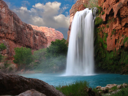
The course of a stream's channel can be affected if the rock layer over which it passes changes from a hard, resistant layer to one that is weaker and more easily eroded. As the softer material is worn away, the resistant rock remains as a step or ledge over which the water in the channel flows. This drop in the stream bed that causes the water to fall vertically or nearly vertically is called a waterfall. Often the drop is steep. A waterfall may also develop where a stream flows over the edge of a plateau or in
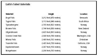
| Earth's Tallest Waterfalls | ||
| Waterfall | Height | Location |
| Angel Falls | 3,212 feet (979 meters) | Venezuela |
| Tugela Falls | 3,110 feet (948 meters) | South Africa |
| Tyssestrengene | 2,795 feet (852 meters) | Norway |
| Browne Falls | 2,744 feet (836 meters) | New Zealand |
| Utigardsfossen | 2,625 feet (800 meters) | Norway |
| Colonial Creek Falls | 2,584 feet (788 meters) | Washington, USA |
| Mtarazi Falls | 2,499 feet (762 meters) | Zimbabwe |
| Yosemite Falls | 2,425 feet (739 meters) | California, USA |
| Espelandsfossen | 2,307 feet (703 meters) | Norway |
| Mongefossen | 2,296 feet (700 meters) | Norway |
areas where glaciers have eroded deep valleys in mountainous terrain and streams flowing from higher parts plunge to the valley floor. In a waterfall, as water continues to fall over the edge, it erodes the bed of the channel at the base of the waterfall. A basin or depression is created, and sediment carried by the stream is deposited here. Depending on their hardness, the rock layers behind the falling water may also be eroded over time by the action of the water. As these softer layers are cut into, the resistant layer under the bed of the stream ultimately loses support and falls into the water at the base of the waterfall. When this occurs, the waterfall retreats farther upstream.
Normally, over time, the stream will erode the resistant rock so the gradient of the channel is not as steep. The waterfall will be reduced to rapids, an area where water in the stream channel rushes downward over hard rocks. The reduction of a major waterfall to rapids may take tens of thousands of years. Eventually, the rapids, too, will be eroded away.
Other erosional features created by streams are canyons and V-shaped valleys. On plateaus and in mountains, a stream erodes a fairly narrow path through the landscape, often only as wide as its channel. It does so because most of its erosional force is directed along its bed. As the stream erodes downward, a process referred to as downcutting, steep slopes remain on either side of the stream's channel. If the stream is cutting through a region composed of rocks that are highly resistant to erosion, a narrow, steep-walled canyon is created. (For further information, see the Canyon chapter.) If the rocks in the region are more susceptible to erosion, rockslides and other types of landslides gradually modify the steep slopes to form a V-shaped valley. (For further information, see the Valley chapter.)
Depositional features
In addition to bars and islands in braided streams and point bars in meandering streams, streams create larger features by depositing sediment. Among these are floodplains, alluvial fans, and deltas.
When the flow of water in a stream becomes too high to be accommodated in the stream's channel, the water flows over the stream's banks and floods the surrounding land. As it does so, the water immediately slows down and drops its sediment load. Coarser sediment is deposited near the channel. Over time, as the process is repeated over and over, the sediment forms mounds called natural levees along the stream's banks. Finer sediment carried by the flood is spread farther away from the channel before it is finally deposited. The flat or gently sloping surface created by the repeated deposition of sediment along a stream is called the stream's floodplain. A floodplain is widened as a stream meanders across a landscape. (For further information, see the Floodplain chapter.)
When a stream whose channel has been confined in a narrow valley or canyon in a highland area flows out into a broader, flatter valley or plain, its velocity and gradient suddenly decrease. No longer confined to a narrow channel, the water spreads farther as it moves away from the base of the highlands. Large rocks and other heavy material are deposited first, followed by other material in decreasing size. As more water flows onto the valley and more sediment is deposited, a wide, fan-shaped pile known as an alluvial fan forms.
When a stream enters a body of standing water, such as an ocean or a lake, again there is a sudden decrease in velocity. The stream drops its sediment load in a deposit called a delta. Deltas build outward from a coastline, but will survive only if ocean currents are not strong enough to remove the sediment. As the velocity of a stream decreases on entering the delta, the stream becomes choked with sediment, similar to what occurs in a braided stream channel. Instead of braiding, however, the stream channel breaks into many smaller channels called distributaries that carry water and sediment to the delta's edges. (For further information, see the Delta chapter.)
Forces and changes: Construction and destruction
Water running down a slope becomes a stream when there is enough water to form a tiny rivulet with a channel to contain the water. In its early stage, a stream may carry water only after rain falls or snow melts. In this instance, it is said to be an intermittent stream. In contrast, a permanent stream is one that has cut its valley deeply enough so that ground-water seeps into it and keeps it flowing between rainfalls. Beneath Earth's surface, water fills the pore spaces and openings in rocks. This water, which comes from rain or melted snow that is drawn downward through the soil by gravity, is known as groundwater. At a certain level below ground, all the openings in the rocks are completely filled with groundwater. The upper surface of this saturated zone is known as the water table.
A stream has a natural tendency to reach a base level. This refers to the point at which the stream reaches the elevation of the large body of water, such a lake or ocean, into which it drains. Aided by gravity, a stream flows toward the level of its final destination as quickly as possible. The larger the difference in height between the stream and its destination, the greater the erosive or cutting force of the stream. For most larger streams, base level is sea level. For tributaries, smaller streams that flow into larger ones, base level is the entry point where they empty into the larger stream.
Streams erode because they have the ability to pick up sediment and transport it to a new location. That sediment may come from several sources: It may have been eroded from the bed and banks of the stream, or it may have fallen into the stream after moving (slowly or quickly) down a slope bordering the stream's channel.
A stream erodes through two actions: hydraulic action and abrasion. Hydraulic action is the force exerted by the water itself. It tends to work along the banks of streams, attacking and undermining layers of soil and rock. Abrasion is the grinding and scraping of the stream's banks and bed by the sediment carried in the stream as the suspended load and bed load.
The Literary Landscape
"The overall impression here, as one surveys the river spread out over the gravel bars, is of a suspension of light, as though light were reverberating on a membrane. And a loss of depth. The slope of the riverbed here is nearly level, so the movement of water slows; shallowness heightens the impression of transparency and a feeling for the texture of the highly polished stones just underwater. If you bring your eye to within a few inches of the surface, each stone appears to be submerged in glycerin yet still sharply etched, as if held closely under a strong magnifying glass in summer light."
—Barry Holstun Lopez, River Notes: The Dance of Herons , 1979.
The amount of sediment a stream moves depends on the velocity of the stream and the size of the sediment particles. Water moving at a low velocity can move only small, fine particles such as sand, silt, and clay. Sand is a mineral particle with a diameter between 0.002 and 0.08 inch (0.005 and 0.2 centimeter); silt is a mineral particle with a diameter between 0.00008 and 0.002 inch (0.0002 and 0.005 centimeter); clay is a mineral particle with a diameter less than 0.00008 inch (0.0002 centimeter). Water moving at a high velocity can move both small particles and large, coarse particles such as boulders.
A stream will continue to carry its load as long as its velocity remains constant or increases (if it increases, it can carry an even larger load). Any change in the geography of the landscape that causes a stream channel to bend or rise (lessening its gradient) will slow the flow of water in the channel. As soon as a stream's velocity decreases, it loses the ability to carry all of its load and a portion will be deposited, depending on how much the stream slows down. Particles will be deposited by size with the largest settling out first.
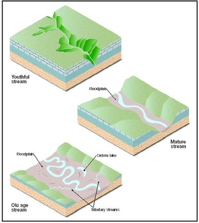
Stream stages
Geologists characterize streams as youthful, mature, and old. Typically, streams have steep gradients near their sources, or beginnings, and gentle gradients as they approach their mouths, or ends. Discharge increases downstream as more tributaries connect with main streams as they flow toward their base levels. Because of this, stream channels also become deeper and wider downstream.
A youthful stream has a fairly straight channel and a steep gradient. It generally flows in a V-shaped valley in a highland or mountainous area with little shifting of its channel. Its velocity is high, and it is actively lowering its channel through downcutting in order to reach base level. In this stage, a stream has little, if any, floodplain. Rapids and waterfalls may mark its course.
A stream in its mature stage has a moderate gradient and velocity because it has eroded its bed downward and is closer to base level. Since it has slowed down, the stream begins to meander. While it is still eroding downward, the stream's main force of erosion is lateral (horizontal) as it begins winding back and forth, carving out a valley floor between valley walls or bluffs. Periodically, the stream will flood all or a part of its valley, depositing alluvium on its developing floodplain.
An old age stream has nearly reached its base level, and its gradient and velocity are very low. Because its velocity is low, it has lost its ability to erode downward. In fact, it deposits as much material as it erodes. The stream meanders greatly in its nearly flat valley. It has a wide, well-developed floodplain marked with oxbow lakes.
Graded stream
A stream with the correct gradient and channel characteristics to maintain the velocity required to transport its sediment load is known as a graded stream. It is a stream that is in equilibrium or balance. On average, it is neither eroding nor depositing sediment but simply transporting it. This involves a balance among base level, discharge, channel shape or size, and sediment load. Any changes to one or more of these by some event—lowering of sea level, the uplift of a land area containing a stream, the blocking of a stream channel by natural or artificial means—will result in erosion or deposition until a new balanced state is reached.
Spotlight on famous forms
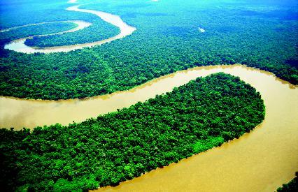
Amazon River, Peru and Brazil
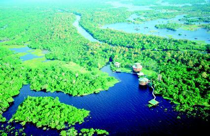
The Amazon River is the world's second longest river (the Nile River in Africa is the longest). It runs for about 3,900 miles (6,275 kilometers) from the Andes Mountains in northern Peru to the Atlantic Ocean near Belem, Brazil. When it enters the ocean, the Amazon discharges about 7,000,000 cubic feet (198,450 cubic meters) of water per second. The width of the Amazon ranges from about 1 to 8 miles (1.6 to 13 kilometers).
Although the Amazon is usually only about 20 to 40 feet (6 to 12 meters) deep, there are narrow channels where it can reach a depth of 300 feet (91 meters). Almost every year, the Amazon floods, filling a flood-plain up to 30 miles (48 kilometers) wide. The fresh layer of sediment deposited by the flood makes the surrounding region extremely fertile.
The Amazon basin (the area drained by the Amazon River) is the largest river basin in the world. It covers an area of about 2,500,000 square miles (6,475,000 square kilometers), or almost 35 percent of the land area of South America. The volume of water that flows from the basin into the Atlantic is about 11 percent of all the water drained from all the continents of Earth.
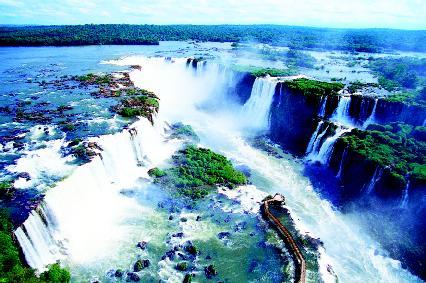
Iguazú Falls, Argentina and Brazil
From its source in the mountains not far from the Atlantic Ocean, the Iguazú (pronounced ee-gwah-ZOO) River flows westward across southern Brazil before entering Argentina and Paraguay. In the language of the native people of the region, Iguazú means "great waters." Along its 745-mile (1,200-kilometer) course, the river flows over 70 waterfalls as it seeks its base level.
The most famous of these waterfalls is located on the border between Argentina and Brazil. The Iguazú Falls is composed of 275 individual falls strung out along the rim of a crescent-shaped cliff about 2.5 miles (4 kilometers) long. The river drops 269 feet (82 meters) at the falls. The water in the river flows over the edge of the falls at an average rate of 553 cubic feet (17 cubic meters) per second.
The falls were created nearly 100,000 years ago when a volcanic eruption produced a lava flow that stopped abruptly, forming a huge, natural cliff.
Volga River, Russia
The Volga River in western Russia is the longest river in Europe. It begins in the Valdai Hills northwest of Moscow and flows for about 2,200 miles (3,530 kilometers) before forming a great delta where it enters the
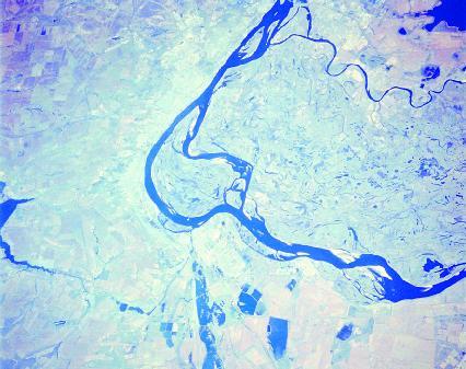
Caspian Sea. Its source is only 740 feet (226 meters) above sea level. Combined with its many tributaries, the Volga River drains an area of over 502,000 square miles (1,300,000 square kilometers).
Much of the water that flows in the Volga River comes from snowmelt. Many large dams have been built on the river to provide hydroelectricity and water for irrigation. Prior to the dams being built, the river carried an estimated 25.5 million tons (23 metric tons) of sediment to the Caspian Sea. The dams have also reduced the amount of natural floods along the river and the velocity of the river's flow.
For More Information
Books
Leopold, Luna B. A View of the River . Cambridge, MA: Harvard University Press, 1994.
Leopold, Luna B. Water, Rivers and Creeks . Sausalito, CA: University Science Books, 1997.
Martin, Patricia A. Fink. Rivers and Streams . New York: Franklin Watts, 1999.
Schuh, Mari C. What Are Rivers? Mankato, MN: Pebble Books, 2002.
Web Sites
"Earth's Water: River and Streams." U.S. Geological Survey . http://ga.water.usgs.gov/edu/earthrivers.html (accessed on August 14, 2003).
RiverResource . http://riverresource.com/ (accessed on August 14, 2003).
"Rivers and Streams." Missouri Botanical Garden . http://mbgnet.mobot.org/fresh/rivers/index.htm (accessed on August 14, 2003).
"River World." Kent National Grid for Learning . http://www.kented.org.uk/ngfl/rivers/index.html (accessed on August 14, 2003).
"Virtual River." Geology Labs On-line Project . http://vcourseware.sonoma.edu/VirtualRiver/ (accessed on August 14, 2003).
The most famous of these waterfalls is located on the border between Argentina and Brazil. The Iguazú Falls is composed of 275 individual falls strung out along the rim of a crescent-shaped cliff about 2.5 miles (4 kilometers) long. The river drops 269 feet (82 meters) at the falls
Thank you so much!
i fi have the awsner to this it would be a huge help for my project.
i am doing this for a college project and i need to know about waterfalls.
I am a Ph.D scholar ( Geophysics)It is a very informative topic.I have a question ,that can the braided and sinous meandering channels exist side by side or they are always in a sinlge chain structure?
Thanking You
Best Regards
Tayyab.
I am doind B.Ed at edgewood, this information has helped me a lot and I thank you for giving such knowledge.