Valley
Valleys are one of the most common landforms on the surface of the planet. They are carved by flowing water or flowing ice through the process of erosion, which is the gradual wearing away of Earth surfaces through the action of wind and water. Valleys take on a wide variety of forms—from steep-sided canyons, such as the Grand Canyon on the Colorado River, to broad plains, such as the lower Mississippi River valley. The form of a valley depends on many factors, including what is eroding it, the slope of the land surface, the nature of the soil or rock where the valley is being created, and time.
The shape of the land
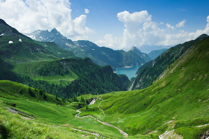
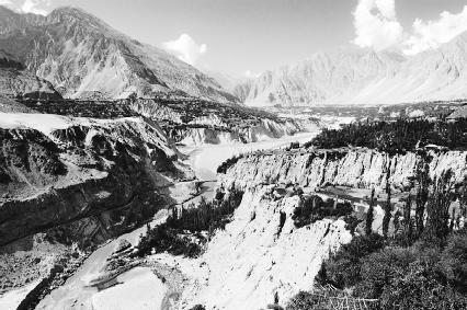
A valley is a relatively large hollow or depression bounded by hills or mountains on Earth's surface that is developed by stream erosion or glacial activity and that is drained externally. A basin is another hollow or depression on Earth's surface, but it has no outlet to drain the water. (For further information, see the Basin chapter.) Geologists refer to any body of running water moving downslope in a defined channel as a stream (a river is a large stream). A glacier is a large body of ice that formed on land by the compaction and recrystallization of snow, survives year to year, and shows some sign of movement downhill due to gravity. The three main types of valleys are the V-shaped valley, the flat-floored valley, and the U-shaped valley.
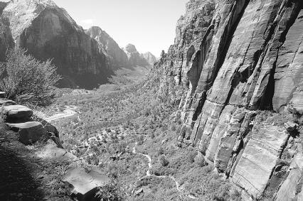
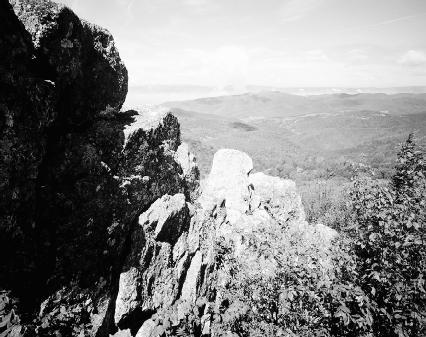
A V-shaped valley is a narrow valley that has a profile suggesting the form of the letter "V," characterized by steeply sloping sides. It results from a stream eroding downward, a process referred to as downcutting. V-shaped valleys form in mountains or other highland areas where streams are in their beginning or "youthful" stage and are flowing rapidly down steep slopes. The bottom of a valley is called its floor. In highland areas
near a stream's source, or beginning, the valley sides slope down almost directly to the stream's banks, or sides of its channel. The valley floor in this region is narrow or even nonexistent.
Valley: Words to Know
- Alpine glacier:
- A relatively small glacier that forms in high elevations near the tops of mountains.
- Base level:
- The level below which a stream cannot erode.
- Erosion:
- The gradual wearing away of Earth surfaces through the action of wind and water.
- Fjord:
- A deep glacial trough submerged with seawater.
- Floodplain:
- An area of nearly flat land bordering a stream that is naturally subject to periodic flooding.
- Glacial trough:
- A U-shaped valley carved out of a V-shaped stream valley by the movement of a valley glacier.
- Glacier:
- A large body of ice that formed on land by the compaction and recrystallization of snow, survives year to year, and shows some sign of movement downhill due to gravity.
- Hanging valley:
- A shallow glacial trough that leads into the side of a larger, main glacial trough.
- Levee (natural):
- A low ridge or mound along a stream bank, formed by deposits left when floodwater slows down on leaving the channel.
- Mass wasting:
- The spontaneous movement of material down a slope in response to gravity.
- Meander:
- A bend or loop in a stream's course.
- Rift valley:
- The deep central crevice in a mid-ocean ridge; also, a valley or trough formed between two normal faults.
- Stream:
- Any body of running water that moves downslope under the influence of gravity in a defined channel on Earth's surface.
- U-shaped valley:
- A valley created by glacial erosion that has a profile suggesting the form of the letter "U," characterized by steep sides that may curve inward at their base and a broad, nearly flat floor.
- Valley glacier:
- An alpine glacier flowing downward through a preexisting stream valley.
- V-shaped valley:
- A narrow valley created by the downcutting action of a stream that has a profile suggesting the form of the letter "V," characterized by steeply sloping sides.
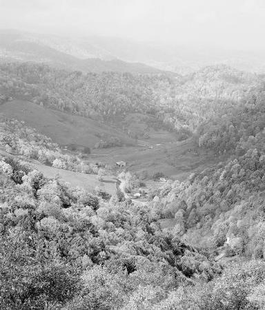
Downstream, as the gradient or slope of the stream's channel lessens and becomes more gentle, the floor of the valley widens. A stream in this stage is no longer considered youthful but "mature." A stream flowing at a moderate to low gradient tends to erode more along the banks of its channel than along its bed or bottom. Thus, the stream slowly sweeps across the valley floor in a series of S-shaped bends called meanders (pronounced me-AN-ders). Over time, as the stream continues to meander, it erodes away material on the valley floor, ever widening it. The shape of the valley changes progressively from a sharp V to a broader V to one that has a flat floor. This latter type of valley, with a floor that is horizontal and often wide, is known as a flat-floored valley. This type of valley is the most common.
Streams are systems for moving sediment—rock debris such as clay, silt, sand, gravel, or even larger material—across Earth's surface to the world's oceans and seas. Naturally and routinely, the flow of water in a stream may become too high to be accommodated in the stream's channel. The water then flows over the stream's banks and floods the surrounding land. As it does so, the water immediately slows down and drops any sediment it was carrying. Coarser sediment is deposited near the channel. Over time, as the process is repeated over and over, the sediment forms mounds called natural levees along the stream's banks. Finer sediment (sands, silt, and clay) carried by the water is spread farther away from the channel before it is finally deposited. The flat or gently sloping surface created by the repeated deposition of sediment along a stream is called the stream's floodplain. A floodplain may cover all or just a portion of the valley floor. (For further information, see the Stream and river and Floodplain chapters.)
A U-shaped valley is a valley that has a profile suggesting the form of the letter "U," characterized by steep sides that may curve inward at their bases and a broad, nearly flat floor. Specifically, a U-shaped valley is one carved by glacial erosion. Thick masses of ice that move slowly over Earth's surface, glaciers are found in regions close to the North and South Poles, the extreme northernmost and southernmost points on the globe, or in mountains at high elevations. Those that form over large areas of continents close to the poles are called continental glaciers or ice sheets. Two continental glaciers are found on Earth: one covers 85 percent of Greenland in the Northern Hemisphere and the other covers more than 95 percent of Antarctica in the Southern Hemisphere. Relatively small glaciers that form in high elevations near the tops of mountains are called alpine or mountain glaciers. (For further information, see the Glacial landforms and features chapter.)
Because of their size and weight, continental glaciers destroy topography, leveling the surface features of a landscape. The effect of alpine glaciers is not as extreme. They flow down pre-existing V-shaped valleys created by streams to form U-shaped valleys. Because of this, they are also known as valley glaciers. Whereas a stream only occupies the floor (or a main portion of it) in a V-shaped valley, a valley glacier occupies the entire valley, eroding both the sides and the floor as it moves, deepening and widening the valley. U-shaped valleys are also known as glacial troughs.
Draining an area, streams tend to flow across the landscape in a treelike pattern: the smallest streams (the outer branches) flow into larger streams (the inner branches), which flow into the main stream (the trunk). Smaller streams that flow into larger ones are known as tributaries. When valley glaciers fill an area, they may occupy the valleys created
by a main stream and its nearest tributaries. Tributary valleys almost always join the main stream valley at the same altitude or height, but glacial action deepens the main valley more than its side valleys. The shallower glacial troughs created by these smaller valley glaciers (known as tributary glaciers) are called hanging valleys. If temperatures in the area increase, causing the glaciers to melt and retreat, meltwater from the glaciers may form streams that run through these hanging valleys. In spectacular instances, streams in hanging valleys often fall to the floor of the main valley as a waterfall.
In certain instances, a valley glacier may flow all the way to a coastline, carving out a deep, narrow U-shaped valley. If the glacier melts, the valley may become flooded with seawater, forming an inlet known as a fjord (pronounced fee-ORD).
The term rift valley is used to describe an area where a section of Earth's crust (thin, solid outermost layer of the planet) has dropped down between two normal faults (cracks or fractures in Earth's crust along which rock on one side has moved relative to rock on the other). Essentially, whenever the planet's crust is subjected to compression or tension caused by heat forces beneath the crust, faults develop, and some blocks of rock drop along these fractures relative to the ground on either side. A rift valley is not a true valley. The dropped-down block or crust that formed a depression on the surface of the ground is correctly called a graben (pronounced GRAH-bin). Rift valleys, which are found around the world on continents and the ocean floors, are commonly sites of volcanic and earthquake activity. (For further information, see the Fault chapter.)
Forces and changes: Construction and destruction
The dominant agent of erosion on the surface of the planet is flowing water. Although the ice in glaciers is solid, it also flows (though more slowly than water in a stream channel). Both streams and glaciers move downhill under the influence of gravity, the main driving force behind almost all agents of erosion. As they move downward, they transport sediment they have picked up or that has fallen into or onto them.
Stream erosion
The shaping of stream valleys is due to a combination of erosion by flowing water and mass wasting, the spontaneous movement of Earth material down a slope in response to gravity. This does not include material transported downward by streams, winds, or glaciers. Through mass wasting, material from higher elevations is moved to lower elevations where streams, glaciers, and wind pick it up and move it to even lower elevations. Mass wasting occurs continuously on all slopes. While some mass-wasting processes act very slowly, others occur very suddenly. The general term landslide is used to describe all relatively rapid forms of mass wasting. (For further information, see the Landslide and other gravity movements chapter.)
The Literary Landscape
"The famous Yosemite Valley lies at the heart of it, and it includes the head waters of the Tuolumne and Merced rivers, two of the most songful streams in the world; innumerable lakes and waterfalls and silky lawns; the noblest forests, the loftiest granite domes, the deepest ice-sculptured cañon, the brightest crystalline pavements, the snowy mountains soaring into the sky twelve and thirteen thousand feet, arrayed in open ranks and spiry pinnacled groups partially separated by tremendous cañons and amphitheatres; gardens on their sunny brows, avalanches thundering down their long, white slopes, cataracts roaring gray and foaming in the crooked rugged gorges, and glaciers in their shadowy recesses working in silence, slowly completing their sculpture; new-born lakes at their feet, blue and green, free or encumbered with drifting icebergs like miniature Arctic Oceans, shining, sparkling, calm as stars."
—John Muir, Our National Parks , 1901.
Once a stream forms, it seeks out its base level, which is the level below which the stream cannot erode. Base level is the elevation of the large body of water, such as a lake or ocean, into which a stream drains. The general or ultimate base level for most larger streams is sea level. For
a tributary, base level is the point where it empties into a larger stream. Aided by gravity, a stream tries to reach its base level as quickly as possible. The larger the difference in height between the stream and its base level, the greater the erosive or cutting force of the stream. Temporary base levels may form along a stream's course, such as those created by a lake or resistant rock.
The resistance of the rock over which a stream flows determines the shape of its initial stream valley. In a highland area, a stream's erosional force is directed along its bed, not its banks, as it seeks to lower its channel to base level. If the rock over which the stream flows in this area is hard and resistant to erosion, the stream will cut a narrow, steep-walled canyon. The valley created exists as a nearly vertical notch with no floor. If the rock is less resistant to erosion, the stream will still downcut, but the sides of the valley will take on the characteristic V shape as mass wasting—rockfalls and other types of landslides—widens the upper portion of the valley.
Rock hardness is an important factor in erosion, but a stream's ability to cut depends on how much sediment it carries and how fast it is flowing. The sediment carried by a stream may have been eroded from the bed and banks of the stream, or it may have fallen into the stream after a mass-wasting event moved it down a slope bordering the stream's channel. Water moving at a low velocity or speed can move only small, fine particles such as sand, silt, and clay. Water moving at a high velocity can move a larger amount of both small particles and large, coarse particles such as boulders. Water that flows erratically, giving rise to swirls and eddies, is said to be turbulent, and turbulent water can move the coarsest and greatest amount of particles.
A stream erodes through hydraulic action and abrasion. Hydraulic action is the force exerted by the water itself. This force works along the banks of streams, attacking and undermining layers of soil and rock. Abrasion is the grinding and scraping of the stream's banks and bed by the sediment carried by the stream.
When a stream flows out of a highland area, reaching an elevation that is closer to its base level, it begins to slow down. In this state, the stream is still eroding downward, but its main force of erosion is directly laterally or horizontally against its banks. It begins meandering, winding back and forth, carving out a valley floor between valley walls or bluffs. Periodically, the stream will flood all or a part of its valley, depositing sediment on its developing floodplain.
At the lower reaches of a stream, where it approaches base level, the valley it flows through will be open, wide, and flat-bottomed. Valley walls, if they even exist, will be far away from the stream channel.
Glacial erosion
Moving glaciers not only transport material as they move, they also sculpt and carve away the land beneath them. A glacier's weight, combined with its gradual movement, can drastically reshape the landscape.
A valley glacier moves to lower elevations under the force of gravity through a combination of internal flow and sliding at its base. The ice in a glacier is so dense and under such pressure that it begins to behave like a thick tar, flowing outward and downward. Glacial movement through this internal flow is very slow. On average, it measures only an inch or two (a few centimeters) a day. In a valley glacier, ice in the upper central part moves faster than ice at the sides, where it is in contact with the valley walls. The considerable weight of a valley glacier also creates enormous pressure at its base, and this pressure lowers the temperature at which ice melts. A layer of water develops between the glacial ice and the ground. The water reduces friction by lubricating the ground and allowing the glacier to slide on its bed.
A valley glacier is capable of eroding and transporting huge amounts of sediment. As the glacier moves, its ice flows into and refreezes in fractures in the rock walls and floor of the valley. The glacier then plucks that rocky material away with it, some of which may be boulders the size of houses. This
material then becomes embedded in the ice at the base and along the sides of the glacier. As the glacier continues to move, the embedded material abrades or scrapes the rock surrounding the glacier like a giant file.
Following an existing V-shaped valley, a glacier erodes the valley, deepening and widening it. It may increase the width of the valley by as much as tens of miles (kilometers). The glacier also flattens the valley floor because ice tends to cut down over a wider area than flowing water. When the glacier finally retreats, a thick layer of glacial sediment called ground moraine remains, filling in any irregularities in the valley floor.
Spotlight on famous forms
Napa Valley, California
California's Napa Valley is world-renowned for having a wide variety of soils and climate conditions that help produce grapes that are made into quality wines. The narrow valley is 30 miles (48 kilometers) long and 1 to 6 miles (1.6 to 9.6 kilometers) wide. It occupies an area of about 300,000 acres (120,000 hectares).
At its northern end lies the region's largest mountain, Mount St. Helena. Its southern end opens to San Pablo Bay, an arm of the San Francisco Bay system. The valley is bordered by two mountain ranges, the Vaca Mountains on the east and the Macayamas Mountains on the west. Flowing through the middle of this valley is the 50-mile-long (80-kilometer-long) Napa River.
The valley began to form about four million years ago when heat forces beneath Earth's crust in this region forced land on either side of the present-day valley upward into mountains. Certain areas between the mountains were widened and lowered into troughs as a result. Napa Valley is such an area. After the valley's formation, eruptions from several volcanoes surrounding the valley blanketed the land in volcanic cinders and ash that accumulated to layers thousands of feet thick.
Shenandoah Valley, Virginia
The Shenandoah Valley in northern Virginia is part of the Great Valley of the Appalachians, which stretches from Pennsylvania to Alabama. The Shenandoah Valley, which is about 150 miles (241 kilometers) long, lies between the Blue Ridge Mountains on the east and the Allegheny Mountains on the west.
Both mountain ranges are part of the Appalachian Mountain system, which formed over 300 million years ago. The powerful erosive forces of water, wind, and frost have greatly eroded the Appalachians since then. Water runoff has carved the mountains' distinctive alternating pattern of ridges and valleys.
The Shenandoah River, which runs through the valley, is a tributary of the Potomac River. It was the first of the tributaries in the area to reach the soft limestone layer that is now the base of the Shenandoah Valley. Intercepting stream after stream west of the Blue Ridge Mountains, the Shenandoah River grew. As it did, it carved out the Shenandoah Valley, dissolving the limestone and carrying the sediments north to the Potomac.
Yosemite Valley, California
Lying in the Sierra Nevada Mountains in central California is a 0.5-mile (0.8-kilometer) deep depression. Measuring 7 miles (11 kilometers) long and 1 mile (1.6 kilometers) wide, Yosemite Valley lies at the heart of Yosemite National Park, which encompasses 761,170 acres (304,468 hectares).
The Merced River runs through the valley. Geologists estimate that a few million years ago, it began to carve a valley where the present-day
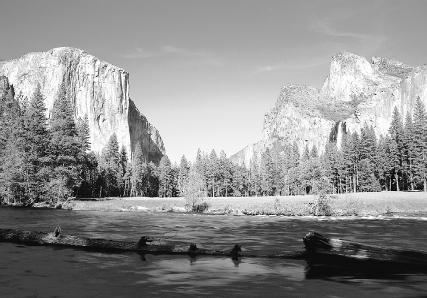
Yosemite Valley lies. The Sierra Nevada Mountains were uplifted and tilted westward, causing the river to gradually, then rapidly, erode a deep, steep-walled canyon. About 2 million years ago, North America's climate began to cool and glaciers began to form. During one of the major glacial periods, about 700,000 years ago, ice thickness in the area was up to 6,000 feet (1,829 meters). Massive, flowing glacial ice caused tremendous amounts of rock to be carved and transported to the area, creating massive rock formations that still exist.
The flow and retreat of glaciers through Yosemite Valley occurred many times until about 10,000 years ago, when the last major glacial period ended in North America. What remained was a U-shaped valley that was actually deeper than the present-day Yosemite Valley. Rock debris from the glacier had dammed the valley creating ancient Lake Yosemite, which covered the valley floor. Streams from hanging valleys above fell in towering waterfalls. The tallest of these is Yosemite Falls, which presently drops 2,425 feet (739 meters) to the valley floor. Ultimately, sediment filled in the lake until it formed the existing valley floor.
For More Information
Books
Huber, N. King. The Geologic Story of Yosemite National Park . Washington, D.C.: U.S. Geological Survey, 1987.
Web Sites
"A Glacier Carves a U-Shaped Valley." U.S. Geological Survey and the National Park Service . http://wrgis.wr.usgs.gov/docs/parks/glacier/uvalley.html (accessed on August 14, 2003).
"Valley and Stream Erosion." Bryant Watershed Project . http://www.watersheds.org/earth/valley.htm (accessed on August 14, 2003).
Valley Glaciers . http://www.zephryus.demon.co.uk/geography/resources/glaciers/valley.html (accessed on August 14, 2003).
The part i liked was the valley vocab.
This is one of the most enjoyable reading i heard so far. Keep up the great work! The R. E. F. ocean learning club of 4th and 5th graders!
I had to do a project about the differnece of Valley and Canyon.
Without this website , Iwould have failed, thanks alot :)
Awesome Website anyway
Ps.you are awsome
:)