Volcano
Volcanoes are landforms whose shapes may remain unchanged for centuries or may change drastically in minutes. Some exist singly, looming over a flat landscape. Others exist in groups, forming mountain ranges. Scores of volcanoes remain unseen, hidden beneath the surface of the planet's oceans. These submarine volcanoes are known as seamounts. (For further information on oceanic landforms, see the Ocean basin chapter.)
The material and processes deep within Earth that form volcanoes have shaped the planet's surface since its beginning more than four billion years ago. Volcanologists, scientists who study volcanoes and volcanic phenomena, have identified the existence of more than forty thousand volcanoes on Earth. Currently, there are about six hundred active volcanoes scattered around the world. Volcanologists classify an active volcano as one that has erupted in the last few hundred years or shows signs of erupting in the near future. A dormant volcano is one that has not erupted for a few hundred years, but has erupted in the last few thousand years. An extinct volcano is one that has not erupted in the last few thousand years and will not, volcanologists believe, ever erupt again.
The word volcano comes from the name of the Roman god of fire and a small island that is part of a group of volcanic islands located just north of Sicily in the Tyrrhenian Sea. Ancient Romans believed that Vulcan, the mythological god who made tools and weapons for other Roman gods, operated his forge beneath the island of Vulcano. One of the present-day Aeolian (pronounced ee-OH-lee-an) Islands, Vulcano has been volcanically active for thousands of years. During the Middle Ages in Western Europe (roughly from 500 to 1500 C.E. ), many people considered the smoking crater on Vulcano to be the entrance to hell. After this period, the word volcano was applied to all such eruptive landforms.
The shape of the land
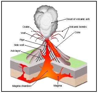
Technically, a volcano is a vent or hole in Earth's surface through which heated material escapes from underground. That material could be any combination of magma (called lava once it reaches Earth's surface), rock fragments, ash, and gas. Ejected through the vent, volcanic material accumulates to form a hill or, if over 1,000 feet (305 meters), a mountain around the opening. It is this accumulating landform that is more commonly referred to as a volcano.
Volcanologists recognize various volcanic landforms, such as shield volcanoes, stratovolcanoes, cinder cones, lava domes, calderas, and lava plateaus. The differing shapes of these landforms are determined by the composition of the magma flowing into the specific volcano from underground.
Magma is molten (melted) rock that contains particles of mineral grains and dissolved gas (primarily water vapor and carbon dioxide). The most abundant element found in magma is silicon, in the form of the oxide silica. (An oxide is a compound of an element and oxygen. As magma cools, the silica crystallizes to become the mineral quartz.) The
Volcano: Words to Know
- Asthenosphere:
- The section of the mantle immediately beneath the lithosphere that is composed of partially melted rock.
- Basalt:
- A dark, dense volcanic rock, about 50 percent of which is silica.
- Convection current:
- The circular movement of a gas or liquid between hot and cold areas.
- Crust:
- The thin, solid outermost layer of Earth.
- Hot spot:
- An area beneath Earth's crust where magma currents rise.
- Lava:
- Magma that has reached Earth's surface.
- Lithosphere:
- The rigid uppermost section of the mantle combined with the crust.
- Magma:
- Molten rock containing particles of mineral grains and dissolved gas that forms deep within Earth.
- Magma chamber:
- A reservoir or cavity beneath Earth's surface containing magma that feeds a volcano.
- Mantle:
- The thick, dense layer of rock that lies beneath Earth's crust.
- Mountain:
- A landmass that rises 1,000 feet (305 meters) or more above its surroundings and has steep sides meeting in a summit that is much narrower in width than the base of the land-mass.
- Plates:
- Large sections of Earth's lithosphere that are separated by deep fault zones.
- Plate tectonics:
- The geologic theory that Earth's crust is composed of rigid plates that "float" toward or away from each other, either directly or indirectly, shifting continents, forming mountains and new ocean crust, and stimulating volcanic eruptions.
- Pyroclastic material:
- Rock fragments, crystals, ash, pumice, and glass shards formed by a volcanic explosion or ejection from a volcanic vent.
- Ring of Fire:
- The name given to the geographically active belt around the Pacific Ocean that is home to more than 75 percent of the planet's volcanoes.
- Silica:
- An oxide (a compound of an element and oxygen) found in magma that, when cooled, crystallizes to become the mineral quartz, which is one of the most common compounds found in Earth's crust.
- Subduction zone:
- A region where two plates come together and the edge of one plate slides beneath the other.
- Viscosity:
- The measure of a fluid's resistance to flow.
amount of silica in magma determines how easily the magma flows. When discussing the flow rate of magma, volcanologists refer to its viscosity (pronounced vis-KOS-eh-tee), which is the measure of a fluid's resistance to flow. If a fluid is thin and runny, like water, it has a low viscosity or is less viscous (pronounced VIS-kus). If a fluid is thick and slow-moving, like tar, then it has a high viscosity or is more viscous. Magma's viscosity is directly related to its silica content: The higher the silica content, the higher the viscosity and the slower it flows. Temperature and the amount of gas contained in magma also affect its viscosity, but opposite that of silica. When its temperature is high and it contains a vast amount of dissolved gas, magma has a low viscosity and flows quite readily.
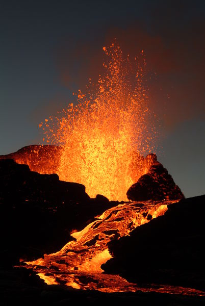
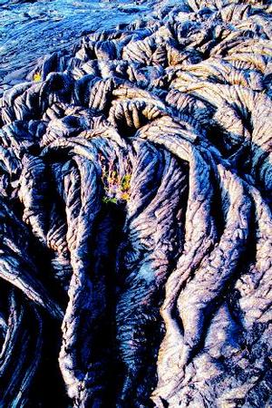
Lava (magma that has erupted from a volcano) can create interesting rock formations once it has run down the side of a volcano and cooled. Two such formations generated by lava flows include aa (pronounced AH-ah) and pahoehoe (pronounced pa-HOY-hoy), which are quite common in the Hawaiian Islands. In fact, about 99 percent of the island of Hawaii is composed of aa and pahoehoe. The different textures of these volcanic rocks are caused by a difference in the viscosity of the lava flows that created them. Slow-moving, cooler, and more viscous lava hardens to form aa, rough blocks that have sharp, jagged edges. Lava flows that are hotter, have a high concentration of gas, and are less viscous harden to form pahoehoe, which has a smooth, coiled surface that resembles rope. While a hard skin develops on the surface of pahoehoe as it cools, hot lava continues to flow beneath the skin, causing the coiled-rope wrinkles that mark its surface. Lava may continue to flow inside hardened pahoehoe for miles.
Shield volcano
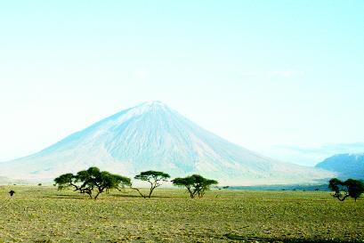
Shield volcanoes are broad landforms with gently sloping sides, resembling a warrior's shield lying on the ground with the curved face up. These types of volcanoes are typically created by successive nonexplosive eruptions of lava that have low silica content and, consequently, relatively low viscosity. The runny lava flows great distances over the wide surface of the volcano, forming thin sheets of nearly uniform thickness. The slope of a shield volcano is seldom more than 10 degrees at its summit and 2 degrees at its base. Hawaii, Tahiti, Samoa, the Galápagos, and many other oceanic islands are actually the upper portions of large shield volcanoes.
Stratovolcano
Stratovolcanoes, also called composite volcanoes, have the most symmetrical cone shape of any volcano types. They are among the most picturesque landforms on Earth. These steep mountains have slopes of up to 30 degrees at the summit, tapering off to 5 degrees at the base. They are built up of alternating layers of lava and layers of pyroclastic (pronounced pie-row-KLAS-tic; fragmented rock, crystals, ash, pumice, and glass shards) material, which have flowed down on different sides of the volcano at different times. The steep slope near the summit is due partly to thick, viscous lava flows that did not travel far downward from the vent. The gentler slope near the base is due to the accumulation of pyroclastic material that the volcano erupted violently and material eroded from the sides of the volcano. Examples of stratovolcanoes include Mount Fuji in Japan, Mount Mayon in the Philippines, and Mount Vesuvius in Italy. In the United States, Mount Rainier and Mount Baker in Washington and Mount Hood in Oregon are classic examples of stratovolcanoes.
Cinder cone
Cinder cones are the steepest of volcanoes, with slopes of 30 to 40 degrees. They are seldom taller than 1,640 feet (500 meters); many are not more than a few hundred feet high. Cinder cones are built entirely or almost entirely of blobs of lava that have broken up into small fragments
or cinders after being ejected in mildly explosive eruptions. The cinders rain back down to form a cone around a bowl-shaped depression or crater at the summit. These volcanoes can grow very rapidly, but they are usually not active for long. Because the material that forms them is fragmented and easily eroded, cinder cones usually do not remain as landforms for an extended period of time. All cinder cones currently on Earth originated within the last 1 to 2 million years; most are less than 150,000 years old. Sunset Crater in Arizona, Stromboli in the Mediterranean Sea, Parícutin in Mexico, and Cerro Negro in Nicaragua are all examples of cinder cones.
Lava dome
Lava domes, also called volcanic domes, form in the craters of volcanoes (mostly stratovolcanoes) after a major eruption. Highly viscous lava with little gas content oozes out of the volcano's vent like toothpaste out of a tube. The pasty lava is too thick to flow, and it solidifies on top of the vent, forming a rounded, steep-sided mound. The building of lava domes can be a forceful process, with small but violent explosions blasting out pieces of the dome. Fresh viscous lava flows then replace and build on the old material, causing the dome to take on a variety of strange shapes. Examples of lava domes include Mono Dome in California and Santiaguito Dome in Guatemala. After Mount St. Helens in the state of Washington erupted in May 1980, a lava dome began to form in its crater. Currently, the dome rises more than 900 feet (275 meters) above the crater floor.
Caldera
Below the vent in a volcano is a passageway called a pipe. The pipe leads down to the magma chamber, a large area where magma collects below Earth's surface. In some highly explosive eruptions, a great percentage or all of a volcano's magma chamber may be emptied. When this occurs, the roof of the magma chamber may be left unsupported. It may then collapse under its own weight, forming a large, usually circular, steep-walled basin known as a caldera (Spanish for cauldron or kettle) across the top of the volcano. Calderas have a diameter ranging from 1 to 15 miles (1.6 to 25 kilometers). Over time, rain and snowmelt may collect in a caldera, forming a lake. Lake Toba, in Sumatra, Indonesia, fills the world's largest caldera. It measures 18.6 miles (30 kilometers) wide and 62 miles (100 kilometers) long. The central part of Yellowstone National Park in Wyoming is a caldera measuring 28 miles (45 kilometers) by 47 miles (75 kilometers). A huge eruption 600,000 years ago created the depression at the heart of the park.
Lava plateau
In some eruptions, lava pours forth through fissures or long, narrow cracks in the ground instead of through a central vent in a volcano. This thin lava tends to spread out rapidly and widely, flooding the surrounding landscape. Repeated outpourings of lava eventually build up to create flat lava plains called lava plateaus. Lava plateaus are also known as flood basalts, after the dark, dense volcanic rock called basalt that floods across the surface of the land. Although erupted in thin sheets, the lava flows accumulate to form deposits thousands of feet thick.
The most famous example of a lava plateau in the United States is the Columbia Plateau, covering most of southern Washington from its border with Idaho west to the Pacific Ocean and extending south into Oregon. In places, it measures 5,000 feet (1,524 meters) thick. The Deccan Plateau of west-central India is much larger, covering some 300,000 square miles (770,000 square kilometers) and accumulating in spots to a thickness of 6,000 feet (1,829 meters). Larger still is the Siberian Traps in central Russia, which formed about 250 million years ago. It covers about 750,000 square miles (1,942,500 square kilometers). If the lava that poured forth to create the Siberian Traps were spread out evenly across the entire planet, it would create a layer 10 feet (3 meters) thick.
A Venutian Volcano on Earth?
The only active volcano in the East African Rift Valley in northern Tanzania, Ol Doinyo Lengai (pronounced ol DOYN-yo LEN-guy) rises 9,479 feet (2,890 meters). Its name means "Mountain of God" in the language of the Masai people who inhabit this region. What makes the strato-volcano so strange and interesting to volcanologists and other scientists is the lava it erupts.
While most of the world's volcanoes erupt silicate lavas, which are made up primarily of silicon and oxygen, Ol Doinyo Lengai erupts a lava rich in calcium and sodium. Volcanologists call this type of lava natrocarbonatite, and it is erupted from no other active volcano on Earth. At about 950°F (510°C), natrocarbonatite lava is approximately one-half as hot as normal lava. It is also the most fluid lava in the world. With a very low gas content, it has a very low viscosity and flows like water.
Since it is not as hot as normal lava, natrocarbonatite lava does not glow as brightly. In sunlight, lava flows from Ol Doinyo Lengai may be mistaken for dark brown or black mudflows. The dark lava quickly solidifies, then changes color to gray. When it comes in contact with moisture, the lava undergoes a chemical reaction that turns it white. This change may occur immediately if it is raining or may take several months in dry conditions. The reaction to moisture also softens the lava, so a person walking on it may sink in slightly.
Ol Doinyo Lengai is unique on Earth, but not in the solar system. Scientists have discovered through satellite photos that similar volcanic structures and lava flows exist on the planet Venus.
Forces and changes: Construction and destruction
A volcanic eruption is among the most powerful forces on Earth. When Mount St. Helens in the state of Washington erupted in May 1980, the energy it released was equivalent to the largest hydrogen bomb ever exploded (a hydrogen bomb equals the power of one thousand atomic bombs). The eruption of the ancient volcano that produced Crater Lake in Oregon, one of the best-known calderas in the world, was forty-two times as powerful as that of Mount St. Helens. One hundred times more powerful was the 1815 eruption of the stratovolcano Tambora on the Indonesian island of Sumbawa. The ash cloud released by the volcano lowered global temperatures by as much as 5°F (3°C) from late spring to early autumn the following year. Subsequent crop failures produced widespread famine.
Earth's interior
The power to change the shape both of a volcano and the landscape around it comes from miles beneath Earth's surface. The interior of the planet is divided into different layers of varying composition. The rocky outer layer that forms Earth's surface is the crust, which varies in thickness from 3 to 31 miles (5 to 50 kilometers). The crust is thickest below land and thinnest below the oceans. Underlying the crust is a thick layer of rocks (different from those composing the crust) known as the mantle. The mantle extends down roughly 1,800 miles (2,900 kilometers) beneath the planet's surface.
The uppermost section of the mantle is a rigid or firm layer. Combined with the overlying solid crust, it makes up the lithosphere (pronounced LITH-uh-sfeer; from the Greek word lithos , meaning "stone"). On average, the lithosphere measures about 60 miles (100 kilometers) thick. The part of the mantle immediately beneath the rigid, cold lithosphere is composed of partially melted rock that is pliable, like putty. This section, called the asthenosphere (pronounced as-THEN-uh-sfeer; from the Greek word asthenes , meaning "weak"), extends to a depth of about 155 miles (250 kilometers).
Cultural Landforms
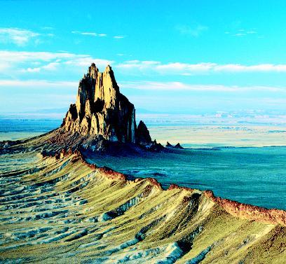
According to Navajo legend, on a towering landform in what is now northwestern New Mexico, a battle took place between a warrior and monster birds that had been terrorizing the ancestors of the Navajo people. Because the warrior was victorious, the Navajo were able to settle in this area around the landform they came to call Tsé Bit'a'i (pronounced say bid-ahih; meaning "rock with wings"). When European settlers arrived centuries later, they thought the landform the Navajo held sacred looked like a giant sailing ship, and so they called it Shiprock.
Shiprock is located in the four corners area of America's Southwest, the only spot where four states (Utah, Colorado, Arizona, and New Mexico) meet. An area of sandstone cliffs and rugged mountains, it is the traditional homeland of several Native American tribes. Shiprock sits in the middle of what volcanologists call the Navajo volcanic field. It is littered with the remains of dozens of extinct volcanoes that last erupted twenty-five to thirty million years ago.
Shiprock stands 1,969 feet (600 meters) above the surrounding plain and measures 1,640 feet (500 meters) in diameter at its greatest width. It is a spectacular example of a volcanic neck or plug. When a volcano stops erupting and becomes extinct, remaining magma and other volcanic material may harden in the volcano's pipe, the passageway between the magma chamber and the vent. Typically, this material tends to be more resistant to erosion than the enclosing volcanic landform. Thus, long after the volcano has eroded away, the volcanic neck stands out against the landscape as the fossil remains of a once great volcano.
Volcanologists estimate that the summit of the original volcano stood almost 1,000 feet (305 meters) above Shiprock's current height. Radiating out from the volcanic neck into the flat, eroded plain are six long, thin, wall-like structures, the ancient volcano's only other visible remains. These vertical structures, called dikes, were created when magma pushed up through cracks that formed in the rock layers beneath the volcano. The rock layers have long since eroded away, leaving the dikes above the surface. The dikes range in length from 0.6 to 5.5 miles (1 to 9 kilometers).
Beneath the mantle is Earth's core, which is composed of a solid inner portion and a liquid outer portion. Both layers of the core are made of the metal elements iron and nickel. Scientists believe temperatures in the core exceed 9,900°F (5,482°C). If the heat energy created by such high temperatures were not released, Earth would become so hot its entire interior would melt. This energy is carried to the surface of the planet by convection currents, the circular movement of molten material deep within Earth.
When a gas or liquid is heated, it expands and becomes less dense (or lighter). It then rises above cooler, denser gas or liquid that surrounds it. This action takes place in Earth's mantle. Under tremendous pressure and
Volcano Facts
- There are 224 volcanoes located in the continental United States and Alaska. About half of them are located in Alaska alone.
- The ash cloud from a volcanic eruption can produce lightning. Collisions between the rapidly moving ash particles produce electric charges, which build up until they discharge to form a lightning bolt.
- The most active volcano in the United States is Kilauea (pronounced kee-low-AY-ah) on the island of Hawaii. Kilauea has been erupting nearly continuously since 1983.
- Stromboli, one of the Aeolian Islands of Italy, has been erupting almost continuously with relatively small explosions and occasional bigger explosions and lava flows for the last 2,000 years.
- The first volcanic eruption ever to be described in detail was that of Mount Vesuvius, which erupted in 79 C.E. and buried the Roman cities of Pompeii and Herculaneum. Pliny the Younger, who witnessed the eruption from a distance of 18 miles (29 kilometers), wrote down his observations afterward.
- Volcanologists estimate that fifteen to twenty volcanoes are erupting around the world at any given moment.
- The 1883 eruption of Krakatau in Indonesia created a tsunami (pronounced tsoo-NAH-mee; a series of great ocean waves caused by a large displacement of water) greater than 115 feet (35 meters) in height that drowned an estimated 36,000 people. The volcanic explosion was heard almost 3,000 miles (4,827 kilometers) away.
- The most common elements in materials erupted by volcanoes are silicon, oxygen, magnesium, iron, aluminum, calcium, sodium, potassium, titanium, phosphorous, carbon, hydrogen, and sulfur.
- The fastest recorded speed of a lava flow was about 37 miles (60 kilometers) per hour at Nyiragongo volcano in Zaire.
- The temperature of basalt, the hottest type of lava, can reach almost 2,150°F (1,200°C).
high temperature, mantle rock near the core heats up and expands. This makes it less dense and more buoyant, and it slowly rises to the surface. Near the surface, the hot rock moves sideways along the underside of the lithosphere, losing its heat. As it cools, the rock becomes denser, or heavier, and sinks back toward the core, only to be heated once again. This continuous motion of heated material rising, cooling, and sinking within Earth's mantle forms circular currents: convection currents. The time involved for heated rocks to rise from the lower mantle to the surface, cool, and return to the interior is estimated to be around 200 million years.

Plate tectonics
The slowly moving convection currents are able to release their heat energy near the surface of the planet because both Earth's interior and its surface are in motion. Earth's lithosphere is not solid, but is broken into many large slabs or plates that "float" on the hot, soft asthenosphere. There are seven large plates, eight medium-sized plates, and a number of smaller ones. These plates are in constant contact with each other, fitting together like a jigsaw puzzle. When one plate moves, it causes other plates to move. The movement of the plates toward or away from each other is in response to the pressure exerted by the convection currents. Scientists used the word tectonics (from the Greek word tekton , meaning "builder") to describe the movements. The scientific theory explaining the plates and their movements and interactions is known as plate tectonics.
The major geologic features of Earth, from volcanoes to mountains to basins to oceanic trenches, are all the result of plate movement. Plates move at rates from about 1 to 6 inches (2.5 to 15 centimeters) per year. The plates interact with each other in one of three ways: they move toward each other (converge), they move away from each other (diverge), or they slide past each other (transform). The boundaries where plates meet and interact are known as plate margins.
Walking in the Footsteps of Giants
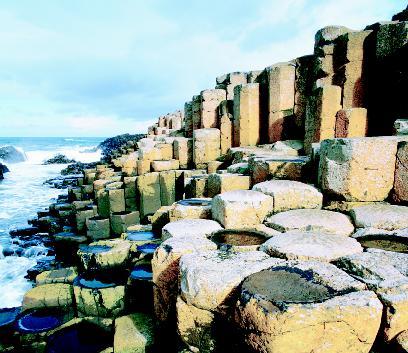
It is called the Giant's Causeway: a mass of closely packed lava columns whose tops seem to form stepping stones that lead from a cliff along the coast of Northern Ireland and disappear under the North Channel. There are approximately forty thousand of these columns, most of which are roughly hexagonal (six-sided) in shape. The rest have between four and eight sides. The tallest columns stand 40 feet (12 meters) high, and the hardened lava in the cliff is 90 feet (27 meters) thick in places.
A causeway is a raised path or road over water or across land that is sometimes covered by water. The ancient Irish believed that a giant created this landform for such a purpose. According to legend, Finn MacCool (Fionn mac Cumhail is the Gaelic spelling of his name) was a warrior and commander of the armies of the kingdom of Ireland. One day, his fighting abilities were questioned by Benendoner, a Scottish giant. MacCool then challenged the giant, but Benendoner could not swim and so was not able to come to Ireland to answer the challenge. Enraged, MacCool used his sword to cut sections from the cliff, which he then threw into the channel between Ireland and Scotland to create the causeway so the two giants could meet to settle their dispute.
Scientists have known since the late eighteenth century that lava flows formed the strange columns, but the cause behind their regular geometric shape remained a mystery until the twentieth century. Scientists now know that the volcanic rock in the area is made of basalt, which flowed smoothly out of fissures or cracks in Earth's surface about sixty million years ago. As basalt cools, it shrinks. The basalt that formed the causeway, however, did not cool slowly and shrink evenly. Scientists believe water most likely may have washed over it, accelerating its cooling. As the basalt cooled rapidly, randomly scattered areas across its surface cooled before other areas. The stress of the rapid cooling and uneven shrinking would have caused cracks to form along the surface and continue downward, much in the same way that mud dries in a puddle of water that has evaporated.
There are three types of convergent plate margins or areas where two plates move toward each other: continental-continental, continental-oceanic, and oceanic-oceanic. When two continental (land) plates converge, they crumple up and compress, forming complex mountain ranges of great height. The rocks making up oceanic crust are denser (heavier) than those making up continental crust. So when an oceanic plate converges with another plate, either continental or oceanic, it slides beneath the other. The region where this occurs is known as the subduction zone, and this is where most of the world's explosive volcanoes form.
When an oceanic plate subducts, or sinks, beneath a continental plate, the leading edge of the oceanic plate is pushed farther and farther beneath the continent's surface. When it reaches about 70 miles (112 kilometers) into the mantle, high temperature and pressure melt the rock at the edge of the plate, forming thick, flowing magma. Since magma is less dense than the rock that typically surrounds it deep underground, the magma tends to rise toward Earth's surface. Driven by pressure created by gas bubbles within it, the magma forces its way through weakened layers of rock to collect in underground reservoirs called magma chambers.
As magma rises through the mantle to Earth's surface, the surrounding pressure on it decreases, allowing the magma to expand. As more and more magma collects in a magma chamber, pressure from the expanding magma increases until it exceeds that of the overlying rock. An explosion then occurs, and the magma is forced out of the chamber upward through cracks or vents in the planet's surface. The severity of the explosion is dependent on the composition of the magma. If it has a low viscosity, its gases can escape rapidly, and it flows rather than exploding. If it has a high viscosity, its gases cannot escape as quickly. Pressure builds until the gases escape violently in an explosion.
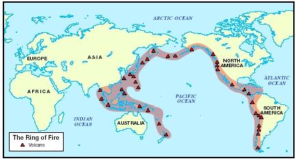
Ring of Fire
Volcanoes are not scattered widely across the surface of Earth. Most are concentrated on the edges of continents, along island chains, or beneath the sea forming long mountain ranges. A majority of the world's active volcanoes above sea level are located in a geographic belt called the Ring of Fire. This belt encompasses the lands on the edges of the Pacific Ocean. It also marks the boundary where the Pacific Plate subducts beneath the plates surrounding it. The Ring of Fire follows the west coast of the Americas from Chile to Alaska. It runs through the Andes Mountains, Central America, Mexico, California, the Cascade Mountains, and the Aleutian Islands. It continues down the east coast of Asia from Siberia to New Zealand, through Kamchatka, the Kurile Islands, Japan, the Philippines, Celebes, New Guinea, the Solomon Islands, and New Caledonia.
Since a vast percentage of all magma reaching Earth's surface does so under the oceans, most of the planet's volcanoes are located there. Some protrude above the water as islands; others lie entirely beneath the surface. Most form along mid-ocean ridges, which are long, narrow structures where oceanic plates are diverging or moving apart and magma rises to fill the gap. The Mid-Atlantic Ridge, where the North and South American plates are diverging from the Eurasian and African plates, is a submerged mountain range with many volcanic features. The volcanic-rich island of Iceland lies directly over the Mid-Atlantic Ridge. (For further information on oceanic landforms, see the Ocean basin chapter.)
Hot spots are special areas where volcanoes form apart from plates converging or diverging, such as in the middle of the Pacific Ocean. At these places, magma rises from the mantle and erupts through Earth's crust
to form a volcano. Volcanologists believe these plumes of magma can exist for millions of years. A famous example of hot spot volcanoes is the string of Hawaiian islands. These islands form a chain of volcanoes because the magma plume that created them has remained stationary while the Pacific plate has shifted. As the plate moved slowly over millions of years, each volcano was cut off from its magma source and a new one formed in its place over the hot spot. The northwesternmost island in the Hawaiian chain contains the oldest rocks and is volcanically extinct; the island of Hawaii, the southeasternmost in the chain, contains the youngest rocks and is the most volcanically active of all the islands. Volcanologists believe it sits directly over the hot spot. More than one hundred hot spots have been active around the planet during the last ten million years, creating some of the world's largest volcanoes, including the present-day Hawaiian volcanoes Mauna Loa and Kilauea.
Spotlight on famous forms
Mauna Loa, Hawaii
Mauna Loa, a very broad, flat shield volcano on the island of Hawaii, is the world's largest volcano and one of the most active. It rises 13,680 feet (4,170 meters) above sea level, and it extends more than 18,000 feet (5,544 meters) to the floor of the Pacific Ocean. From its base under the ocean to its summit, Mauna Loa measures about 32,000 feet (9,754 meters), which makes it taller than Mount Everest in the Himalayas, the
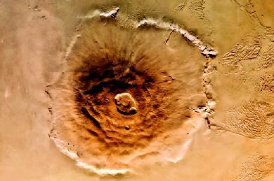
Largest Volcano in the Solar System
Olympus Mons on Mars is the largest of all known volcanoes in the solar system. It is a shield volcano that stands 16 miles (26 kilometers) high and measures 388 miles (624 kilometers) in diameter. A 4-mile-high (6-kilometer-high) scarp, or steep cliff, rims its outer edge. A caldera 50 miles (80 kilometers) wide is located at its summit. If Olympus Mons were placed on the face of Earth, it would cover an area the size of the state of Arizona.
Scientists believe Olympus Mons and other volcanoes on Mars were able to become extremely large because of two main reasons: First, there is less gravity on Mars, which allowed the volcanoes to grow without collapsing under their own weight. Second, the crust on Mars does not move as it does on Earth. This allowed lava to pile up in one large volcano instead of being distributed in an arc of volcanoes, such as the Hawaiian Islands on Earth.
Olympus Mons and all other volcanoes on Mars are extinct. Scientists estimate the youngest lava flows on the gigantic volcano are 20 to 200 million years old.
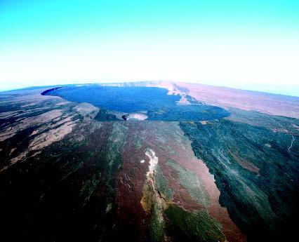
world's tallest mountain on land. The volcano, whose name means "Long Mountain" in Hawaiian, makes up just more than 50 percent of the island of Hawaii. Mauna Loa encompasses an area of about 2,035 square miles (5,271 square kilometers).
Thousands of thin flows of lava have built the volcano over hundreds of thousands of years. It currently has a volume of approximately 9,600 cubic miles (40,000 cubic kilometers). Since its first documented historical eruption in 1834, Mauna Loa has erupted thirty-three times. Its most recent eruption occurred in the spring of 1984. The lava flows it has produced in the past two centuries have covered 310 square miles (803 square kilometer).
At Mauna Loa's summit is a caldera named Mokuaweoweo (pronounced MO-koo-AH-WAI-o-WAI-o; translated literally as "fish section"). It measures 3 miles (5 kilometers) long, 1.5 miles (2.4 kilometers) wide, and 600 feet (183 meters) deep. Volcanologists believe the caldera formed 600 to 700 years ago when the volcano's magma chamber collapsed after an eruption.
Mount Cotopaxi, Ecuador
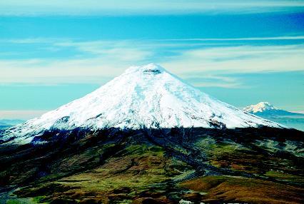
The world's highest active volcano, Mount Cotopaxi, rises 19,388 feet (5,909 meters) above the surrounding highland plain in central Ecuador. A stratovolcano with an almost perfectly symmetrical cone, Mount Cotopaxi is covered in glaciers above 14,930 feet (4,550 meters). Deep valleys are cut into its steep sides, radiating downward from its summit. The crater at its summit measures 2,625 feet (800 meters) by 2,133 feet (650 meters).
Cotopaxi, which in the local Quechua (pronounced KECH-wa) language means "neck of the Moon," has a well-recorded history of explosive eruptions. In 1534, when an invading Spanish army began an attack against the native Incas, the battle was cut short by a massive eruption. Since then, Mount Cotopaxi has erupted more than fifty times, most recently in 1904. An eruption in 1877 melted snow and ice from the summit, producing mudflows (thick mixtures of mud, water, and other surface fragments) that traveled more than 60 miles (100 kilometers) from the volcano.
Mount St. Helens, Washington
Located in southwestern Washington, Mount St. Helens is a relatively young stratovolcano, approximately forty thousand years old. Before its spectacular eruption in May of 1980, it had lain dormant since 1857. Native Americans in the area surrounding the volcano called it Louwala-Clough, meaning "smoking mountain." In the past five centuries, the volcano has produced four major eruptions and dozens of lesser ones. It is the most active volcano in the Cascade Range, a mountain chain that extends about 700 miles (1,125 kilometers) from British Columbia, Canada, to northern California.
Prior to May 18, 1980, Mount St. Helens rose to a height of 9,677 feet (2,950 meters). The fifth-tallest mountain in Washington, it had a nearly perfect cone shape, and its summit glistened in a perpetual cap of snow and ice. When the volcano exploded on that May morning in a continuous nine-hour eruption, it lost its uppermost 1,300 feet (396 meters). A massive earthquake under Mount St. Helens caused its north flank to slide away in the largest landslide in recorded history. This landslide triggered a destructive, lethal sideways blast of hot gas, steam, and rock debris that swept across the landscape as fast as 680 miles (1,095 kilometers) per hour. Within minutes of the blast, an ash plume from the destroyed crater rose 15 miles (24 kilometers) into the sky.
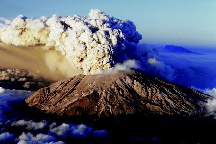
After the eruption, Mount St. Helens's summit stood only 8,364 feet (2,549 meters) above the destroyed landscape surrounding it—about 0.67 cubic miles (2.75 cubic kilometers) of material had been removed from the volcano. Its new horseshoe-shaped crater measured 1.2 miles (1.9 kilometers) by 1.8 miles (2.9 kilometers), and the crater floor was 2,084 feet (635 meters) deep. Within months after the main eruption, small eruptions produced thick lava that formed a lava dome in the crater. Over the next six years, subsequent eruptions generated viscous lava that added layer upon layer to the dome. At the beginning of the twenty-first century, the lava dome towered more than 900 feet (275 meters) above the crater floor.
Crater Lake, Oregon
Measuring 5 miles (8 kilometers) in diameter, Crater Lake has a surface area of 20.6 square miles (53.4 square kilometers). It is enclosed by steep rock walls that rise up almost 2,000 feet (610 meters) above its surface. With a depth of 1,943 feet (592 meters), Crater Lake is the deepest lake in the United States and the seventh-deepest in the world. No springs or other inlets feed the lake. The water that evaporates or seeps out of the lake is replaced mostly by winter snows, which average 44 feet (13.5 meters) a year.
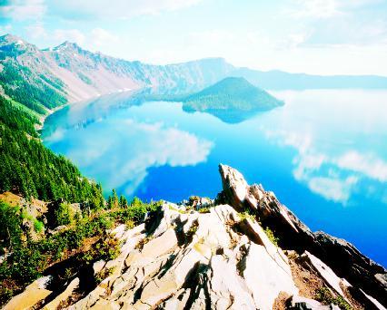
Crater Lake occupies the remains of Mount Mazama, the name given by volcanologists to this ancient cluster of overlapping stratovolcanoes that originally stood at about 12,000 feet (3,658 meters). The caldera formed when Mazama exploded violently 7,700 years ago. The eruption spewed about 18 cubic miles (75 cubic kilometers) of pyroclastic material onto thousands of square miles of surrounding landscape and caused the volcano's magma chamber to collapse. Minor eruptions afterward built a cinder cone on the floor of the caldera. Now known as Wizard Island, the cone rises 764 feet (233 meters) above the surface of the lake on its west side.
After forming, the caldera gradually filled with more than 5 trillion gallons (19 trillion liters) of water from rainfall and melting snow. The deep blue color of the lake is due to its great depth, the clarity of its water, and the way light interacts with water. Sunlight (white light) is made up of all the colors in the spectrum: red, orange, yellow, green, blue, indigo, and violet. Red light has the longest wavelength, violet the shortest. Just as a prism splits sunlight into different bands of color, so does water. As sunlight enters water, the water molecules easily absorb the longer wavelengths of light (reds, oranges, and yellows). The shorter wavelengths are more easily scattered than absorbed. Because of the depth of Crater Lake, all of the longer wavelengths of light are absorbed. Since the lake's water is so clear, the shorter wavelengths of blue and violet are able to penetrate much farther down before being scattered and redirected toward the surface. This creates what the human eye sees as an intense blue color.
For More Information
Books
Decker, Robert, and Barbara Decker. Volcanoes . New York: W. H. Freeman, 1997.
Morris, Neil. Volcanoes . New York: Crabtree Publishing, 1995.
Rosi, Mauro, Papale, Paolo, Lupi, Luca, and Marco Stoppato. Volcanoes . Toronto: Firefly Books, 2003.
Thompson, Luke. Volcanoes . New York: Children's Press, 2000.
Tilling, Robert I. Born of Fire: Volcanoes and Igneous Rocks . Berkeley Heights, NJ: Enslow, 1991.
Trueit, Trudy Strain. Volcanoes . New York: Franklin Watts, 2003.
Van Rose, Susanna. Volcano and Earthquake . New York: DK Publishing, 2000.
Web Sites
"Cascades Volcano Observatory: Learn About Volcanoes." USGS . http://vulcan.wr.usgs.gov/Outreach/AboutVolcanoes/framework.html (accessed on September 2, 2003).
The Electronic Volcano . http://www.dartmouth.edu/~volcano/ (accessed on September 2, 2003).
"Global Volcanism Program." Smithsonian Institution . http://www.volcano.si.edu/gvp/ (accessed on September 2, 2003).
Plate tectonics . http://www.platetectonics.com/ (accessed on September 2, 2003).
Tilling, Robert I. "Volcanoes." USGS . http://pubs.usgs.gov/gip/volc/ (accessed on September 2, 2003).
Volcanic Landforms . http://volcano.und.nodak.edu/vwdocs/vwlessons/landforms.html (accessed on September 2, 2003).
Volcanic Landforms of Hawaii Volcanoes National Park . http://volcano.und.nodak.edu/vwdocs/vwlessons/havo.html (accessed on September 2, 2003).
Volcano World . http://volcano.und.nodak.edu/ (accessed on September 2, 2003).
"Volcanoes of the United States." USGS . http://pubs.usgs.gov/gip/volcus/ (accessed on September 2, 2003).
I think this is a great site, it includes a lot of good information.
Thanx. Liv
Thanx Abby
this site really helped me out a lot. I got a lot of information for my earth science report.
Thanks
Thanks again bye
i learned more about vulcanoes thanks for the information...
Ethan, 15
Thanks 4 everythin'!
--Ace
P.S. AWESOME PICTURES!
Thanks, Joey
Thanks Again,
Lisbit, 12
Thanks so much!! Vanessa
Thanks again