Are hazards due to earthquakes in the New Madrid Seismic Zone overestimated?
Viewpoint: Yes, major earthquakes in the Midwest are rare, and the geological features of the NMSZ are quite different from the earthquake-prone regions of the West Coast.
Viewpoint: No, scientific understanding of earthquake phenomena is still limited, and the large earthquakes of 1811 and 1812 suggest that the threat is genuine.
People have a special dread of earthquakes. They strike without warning, and can in the worst circumstances in a few moments kill thousands of people and leave thousands of others injured and homeless. Hurricanes can be equally devastating, but their arrival is usually predicted hours or even days in advance, giving people the chance to flee or prepare themselves. Tornadoes give less warning than other storms, but their damage is typically very localized. Floods, avalanches, forest fires, and other natural catastrophes wreak havoc with lives and property, but do not present the special risks—or generate the fear—associated with earthquakes. In the developed world, earthquakes are treated as a unique risk to life and property, and in the regions most vulnerable to damaging seismic events, construction of buildings, roads, and other structures are strictly regulated to minimize damage and loss of life in the event of a severe earthquake.
Quakeproof construction comes at significant cost. Cities where the earthquake risk is highest—Tokyo, San Francisco, Los Angeles—have had the greatest success in regulating new construction to high safety standards and in retrofitting older structures to improve safety. In the immediate aftermath of an event such as the earthquake that struck near San Francisco in 1989, resistance to the costs of improving safety in the effected area is naturally diminished. But even in the places where earthquakes are a constant, present danger, funds for quakeproof construction are far from unlimited. Engineering decisions are always made in the context of balancing costs and benefits, and protection from earthquakes is no exception.
At the opposite extreme from the quake-sensitive cities of California are large urban centers such as New York and Chicago. A significant earthquake near either of these cities would create a catastrophe far greater than any in recorded history. Both cities house millions of people in unreinforced masonry buildings that are very likely to collapse during an earthquake. Bridges, tunnels, and mass transportation systems are also not constructed to meet earthquake standards. Large residential and commercial neighborhoods rest upon reclaimed land, or "landfill," likely to liquefy during a quake. But while the risk presented by an earthquake in these cities is enormous, the chance of an earthquake striking either place is, while not zero, very low, and the governments and citizens of New York and Chicago have chosen to treat the threat as negligible.
The region in the Mississippi River Valley known as the New Madrid Seismic Zone presents a more complicated equation of risk and benefit. In the early nineteenth century, New Madrid, Missouri, was the epicenter of some of the largest earthquakes ever recorded in the continental United States. The region was sparsely populated at that time, but historical accounts describe houses falling down in New Madrid, chimneys toppling near St. Louis, and—perhaps apocryphally—church bells ringing as far away as Boston. Because the region is much more heavily populated today, a large earthquake there could cause great death and destruction.
But engineers, scientists, and civic planners have not fully accepted the conclusion that the New Madrid region faces the same earthquake threat as the more seismically active cities on the West Coast. There were no major seismic events in the region during the twentieth century, and those lesser events that occurred (mostly earthquakes of magnitude 5 or less) did virtually no damage. While the quake-prone regions of California rest on or near active fault lines, the geology of the New Madrid region is more complicated, and scientists disagree about its risk profile for the future. More scientific study is underway, and will no doubt continue into the future. In the meantime, decisions about how to incorporate seismic risks into decisions about construction and civic planning will have to be made with incomplete scientific evidence, and the worrisome historical record of a massive quake long ago will have to be measured against the complacency inspired by nearly two hundred quake-free years.
—LOREN BUTLER FEFFER
Viewpoint: Yes, major earthquakes in the Midwest are rare, and the geological features of the NMSZ are quite different from the earthquake-prone regions of the West Coast.
Scientists face a challenge when discussing natural hazards with the public. On the one hand, experts want to warn to public about the hazard and convince citizens to take appropriate steps to mitigate it. On the other hand, overestimating the hazard can have either of two undesirable effects. If the general public does not find the warning credible, the warning will be ignored. Alternatively, accepting an overestimate of the hazard may divert time and resources from other goals that could result in more societal good.
The Cost of Stringent Building Codes
An example of this challenge is illustrated by attempts to estimate the seismic hazard for parts of the central United States due to earthquakes in the New Madrid Seismic Zone (NMSZ). Recent United States Geological Survey maps predict that the seismic hazard in the area is surprisingly high, in some ways exceeding that found in California. Because most earthquake-related deaths result from the collapse of buildings—a principle often stated as "earthquakes don't kill people; buildings kill people"—the primary defense against earthquakes is designing buildings to ensure the safety of the inhabitants. As a result, authorities in Memphis, Tennessee, and other portions of the area are currently considering adopting new building codes that require that buildings be built to the stringent standards of earthquake resistance used in California. Given that these requirements are expensive and might raise building costs by 10 to 35%, it is natural to ask whether the hazard estimate is realistic. Similarly, it is important to consider whether these costs are justified by the resulting increases in public safety or whether alternative, less expensive strategies might better balance costs and benefits.
To consider these questions, it is important to recognize that a community's choice of building codes in earthquake-prone areas reflects a complicated interplay between seismology, earthquake engineering, economics, and public policy. The issue is to assess the seismic hazard and choose a level of earthquake-resistant construction that makes economic sense given that such a design raises construction costs and diverts resources from other purposes. For example, money spent making schools earthquake-resistant is therefore not available for hiring more teachers, improving their pay, or providing better class materials. Similarly, funds spent making highway bridges earthquake-resistant cannot be used for other safety improvements addressing more common problems. Thus, ideally building codes should not be too weak, permitting unsafe construction and undue risks, or too strong, imposing unneeded costs and encouraging their evasion. Deciding where to draw this line is a complex policy issue for which there is no definite answer.
Hazards and Risks
In assessing the potential danger posed by earthquakes or other natural disasters it is useful to distinguish between hazards and risks. The hazard is the intrinsic natural occurrence of earthquakes and the resulting ground motion and other effects. The risk is the danger the hazard poses to life and property. The hazard is a geological issue, whereas the risk is affected by human actions.
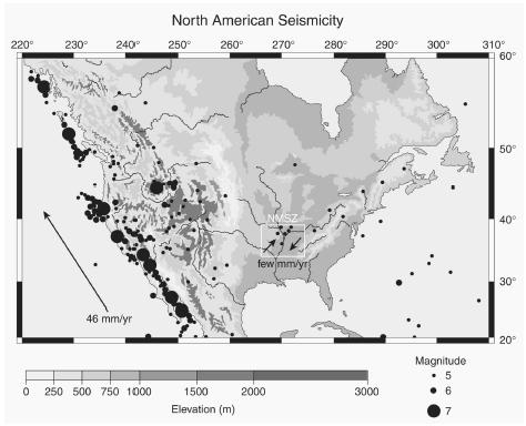
Unfortunately, earthquake risks are not well understood: earthquake risk assessment has been described by one of its founders as "a game of chance of which we still don't know all the rules." Nowhere is this more the case than in the New Madrid Seismic Zone, where the situation is quite different from the familiar case of California, as shown in Figure 1. Earthquakes in California occur as part of the plate boundary zone that spans most of the western United States and that accommodates most of the approximately 45 mm/year net motion between the Pacific and North American plates. (A plate is a layer of rock mass both within the earth and on its crust.) In contrast, the NMSZ is within the generally stable interior of the North American plate, which measurements from the Global Positioning System (a collection of military satellites in known orbits) show deforms by less than 2 mm/year. Hence, major earthquakes are far more common in California: large earthquakes (magnitude 7 or greater) taking up the interplate motion typically occur on major faults in California about every 100 to 200 years, whereas the small intraplate deformation in the NMSZ appears to give rise to earthquakes of this size about every 500 to 1,500 years.
As a result, high-magnitude earthquakes in the Midwest are relatively rare. Since 1816, there are thought to have been 16 earthquakes with magnitude greater than 5 (about one every 10 years), and two with magnitude greater than 6, or about one every 100 years. These have caused some damage but have been considered more of a nuisance than a catastrophe. For example, the largest NMSZ earthquake in the past century, the November 9, 1968 (magnitude 5.5) southern Illinois earthquake, was widely felt and resulted in some damage but caused no fatalities. However, a repetition of the large earthquakes that occurred from 1811 to 1812 in the NMSZ would be very damaging and likely cause deaths. Historical accounts show that houses fell down in the tiny Mississippi river town of New Madrid and that several chimneys toppled near St. Louis. This data implies that these earthquakes had magnitude about 7.2 and provide insight into the effects of future ones.
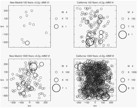
The risk that earthquakes pose to society depends on how often they occur, how much shaking they cause, and how long a time interval we consider. Figure 2 illustrates this idea for California and the New Madrid Seismic Zone, using circles representing approximate areas within which an earthquake might significantly damage some buildings. Earthquakes of a given magnitude occur 100 times more frequently in the NMSZ than in California. However, because seismic energy is transmitted more efficiently by the rock in the Midwest, NMSZ earthquakes shake about the same area as California earthquakes one magnitude unit smaller. Thus, in 100 years much of California will be shaken seriously, whereas only a much smaller fraction of the NMSZ would be. After 1,000 years, much of the NMSZ has been shaken once, whereas most of the California area has been shaken many times.
Guarding Against the Greatest Possible Hazard—Too Costly?
Typically, buildings have useful lives of about 50 to 100 years. Thus, buildings in the Midwest are unlikely to be shaken during their lifetimes, whereas buildings in California are likely to be. Given this difference, several approaches are possible. One, to
Inform the Public with Clear and Accurate Data
This discussion indicates that deciding how to address earthquake hazards in the Midwest is best done by taking a balanced approach of recognizing the hazard while not exaggerating it. Although the public and news media are drawn by images of destruction during earthquakes, it is useful to bear in mind that in the United States earthquakes have claimed an average of nine lives per year nationally, putting earthquakes at the level of risk equal with in-line skating or football, but far less than bicycles. To date, the deaths are primarily in the western United States: earthquakes in the central United States have caused no fatalities for more than 150 years. Unfortunately, official statements and publications intent upon trying to interest the public in NMSZ seismic hazards often use inflated language, for example referring to future magnitude 6 earthquakes, which are unlikely to cause fatalities or major damage, as "devastating". Most such pronouncements do not convey how rare major Midwest earthquakes are (a major earthquake anywhere in the six-state seismic zone is expected less than once every 100 years on average) and do not explain how different the situation is from California. As a result, the impressions given are misleading and may lead to poor policy choices. This is especially unfortunate because the public, media, and authorities have less sophistication in understanding earthquake issues than their counterparts in California. A more sensible way to present seismic hazards would be to be candid with the public so that evaluation of the costs and benefits of alternative policies can be done with as much information on the issues and uncertainties as possible. It would be wise to follow American physicist Richard Feynman's 1988 admonition after the loss of the space shuttle Challenger : "NASA owes it to the citizens from whom it asks support to be frank, honest, and informative, so these citizens can make the wisest decisions for te use of their limited resources. For a successful technology, reality must take precedence over public relations, because nature cannot be fooled."
—SETH STEIN
Viewpoint: No, scientific understanding of earthquake phenomena is still limited, and the large earthquakes of 1811 and 1812 suggest that the threat is genuine.
There is only one thing wrong with the notion that the earthquake hazard in the New Madrid Seismic Zone (NMSZ) is overestimated—geophysicists, geologists, seismologists, and other experts in this field do not know enough about how to predict earthquakes even to make this statement. This is especially true of earthquakes that happen in the Mississippi River Valley. No one knows this better than Arch Johnston, director of the Center for Earthquake Research and Information at the University of Memphis, and coordinator for the Hazards Evaluation Program at the Mid-America Earthquake Center. According to Johnston, New Madrid released more seismic energy in the nineteenth century than did the entire western United States. "In the twentieth century," however, as Johnston reported in Seismicity and Historical Background of the New Madrid Seismic Zone, "the fault zone has been relatively quiescent, with only a few minor-damage events exceeding magnitude 5… . Understanding which century is more representative of normal New Madrid behavior is perhaps our greatest current challenge."
Plate Tectonics
One reason it's a challenge is that the New Madrid Seismic Zone is not like other earthquake-prone regions. Most earthquakes on the planet happen at the boundaries between tectonic plates, or land masses. This plate tectonics model of the earth's surface emerged in the 1960s and gave geoscientists a way to understand previously baffling things like the origin of mountain ranges and oceans, volcanic eruptions, and earthquakes. According to the model, the massive, rigid plates are 30 to 90 miles thick and 12 to 124 miles wide. They move at different speeds and directions on a hot, soft layer of rock called the asthenosphere, whose currents move the plates a few inches a year. Continents and oceans hide plate borders, but it is not hard to pinpoint their locations. Where plates ram together, mountains and volcanoes form; where they crack apart into yawning rifts, oceans are born; where they grind past each other, the land is racked by earthquakes. Though the plate tectonics model has been widely accepted by geophysicists, it does not explain everything about earthquake behavior and predictability.
Questions about Seismic Activity in the NMSZ
In the winter of 1811-1812, three massive earthquakes struck the Mississippi River Valley, which is more than 1,000 miles from the nearest plate boundary. These intraplate (or, within plate) earthquakes were magnitude 8.2, 8.1, and 8.3, making them the most energetic earthquakes ever recorded in the contiguous 48 states. The quakes were not an isolated event. Researchers now have evidence that strong earthquakes occurred in the NMSZ repeatedly in the geologic past. And smaller earthquakes still shake the region—two to three earthquakes a week, with one or two a year large enough for residents to notice—making the central Mississippi Valley the most seismically active region east of the Rocky Mountains. "According to current scientific understanding, these were earthquakes where they shouldn't be," Johnston wrote. "They are outstanding examples of rare major-to-great earthquakes that happen remote from the usual tectonic plate boundary or active intraplate seismic zones… . Our understanding of the faulting process and repeat times of New
One big—and fundamental—question is why an area in an otherwise stable continent would release such massive amounts of seismic energy? Another is, why are faults in an ancient rift system in the crust under the Mississippi River valley, inactive for millions of years, now becoming active? The proposed answers to these questions are varied and speculative.
Perhaps the biggest question is when will the next large New Madrid quake strike? A study in 1992 suggested that it might occur within the next few hundred years. By December of 1998, however, at a meeting of the American Geophysical Union, researchers who had monitored the New Madrid region for signs of strain said the next significant earthquake would not occur for another 5,000 or 10,000 years, if then.
Complicating matters is the fact that geo-physicists do not understand why the New Madrid faults ruptured in the first place, leading geophysicist Paul Segall of Stanford University to tell Science magazine that another magnitude 7 to 8 "can't be dismissed at this point." Segall said strain may have reaccumulated rapidly in the first century after 1812 and is now slowly building toward another quake in the next century or two. Future Global Positioning System (GPS) surveys should show whether the land is motionless, or is slowly inching toward the next big earthquake. "The simplest assumption is, if [big quakes] happened in the past, they can happen in the future," Segall said.
In 1992, Segall, geophysicist Mark Zoback of Stanford, and colleagues compared a 1991 GPS survey with a nonsatellite 1950s land survey and calculated that ground near the fault was moving 5 mm to 8 mm a year. Later, Zoback reported in Science magazine that he and his colleagues "made a detailed study in 1991 of crustal strain with the use of a dense concentration of geodetic stations located astride a single major fault. Our repeated GPS measurements of this network in 1993 and 1997 appear to indicate lower rates of strain accumulation than we originally reported." But lower strain rates do not necessarily imply lower seismic hazard for the region, Zoback said, adding that it is possible that the strain energy released in the storm of large earthquakes in the New Madrid area over the past few thousand years took hundreds of thousands, or even millions of years to accumulate. "If this is the case, a slow rate of strain accumulation over the past 6 years does not imply low seismic hazard," Zoback said. "The persistently high rate of seismic activity in the New Madrid seismic zone over the past few thousand years implies high seismic hazard in the foreseeable future. To communicate any other message to the public would seem to be a mistake."
Can Earthquakes Really Be Predicted?
Such uncertainty about earthquake behavior and prediction extends well beyond the New Madrid Seismic Zone. In February 1999, the journal Nature sponsored a seven-week online debate among top researchers in the field about whether the reliable prediction of individual earthquakes was a realistic scientific goal. According to moderator Ian Main—a reader in seismology and rock physics at the University of Edinburgh and associate editor for the Journal of Geophysical Research —all the debate contributors who expressed an opinion "agree that the deterministic prediction of an individual earthquake, within sufficiently narrow limits to allow a planned evacuation program, is an unrealistic goal." Another contributor, Max Wyss of the Geophysical Institute at the University of Alaska-Fairbanks, said, "The contributions to the debate about earthquake prediction research in Nature so far clearly show that we have hardly scratched the surface of the problem of how earthquake ruptures initiate and how to predict them… . If the current knowledge of the earthquake initiation process is so poorly founded that experienced researchers can maintain the profound differences of opinion present in this debate," he added, "we are in desperate need of the major research effort that is not at present being made."
Hazards Emanating from Outside the NMSZ
There is one more problem with minimizing the earthquake hazard in the New Madrid Seismic Zone—this zone may be the most recognized source of earthquakes in the central Mississippi Valley, but it is not the only source of seismic hazards. Some scientists estimate a 9-in-10 chance that a magnitude 6 or 7 earthquake will occur in the New Madrid Seismic Zone in the next 50 years. Others say a large earthquake will not strike the region for at least 1,000 years, or even 5,000 or 10,000 years. Even the new United States Geological Survey National Seismic Hazard Maps are based on a 1,000-year cycle for magnitude-8 earthquakes in the New Madrid Seismic Zone. But earthquakes occur in a range of magnitudes, and the New Madrid Seismic Zone is not the only source of earthquakes in the Mississippi River valley. In fact, the most recent earthquakes have come from disturbances outside that zone.
In 1968, a magnitude 5.5 earthquake struck whose epicenter was 120 miles southeast of St. Louis. In 1978 another earthquake rattled St. Louis, this one measuring 3.5 on the Richter scale. The source was the St. Louis Fault, discovered in 1948, a 45-mile-long fault running from Valmeyer, Missouri, to Alton, Illinois. In 1990 a magnitude 4.6 earthquake originated south of Cape Girardeau, Missouri, in the Benton Hills, a five-mile-wide forested incline in an otherwise flat alluvial plain. It rattled seven states, and the epicenter was near New Hamburg in Scott County, Missouri, which is outside the New Madrid Seismic Zone. After the earthquake, the Missouri Department of Natural Resources (DNR) and the USGS decided to investigate the source of seismicity in the Benton Hills.
One of the few places in the central Mississippi Valley where faults break the earth's surface is near the town of Commerce, Missouri. Here, starting in 1993, geologist David Hoffman, an earthquake specialist in the Division of Geology and Land Survey for the Missouri DNR, excavated a dozen or more 15-foot-deep trenches in the Benton Hills uplands and uncovered folds in the soil layers. The folds told Hoffman that seismic activity had occurred there within the last 10,000 years and suggested that the faults were still active. The site lies along a linear magnetic feature called the Commerce geophysical lineament. Some geo-physicists believe this northeast-trending lineament may represent a fault zone more than 150 miles long. It is still poorly understood, but this geologic feature could pose another large seismic threat to the region. "There are lots of faults in the area, and it might [indicate] the potential for earthquakes in the future," Hoffman told the St. Louis Riverfront Times in 1999. "It takes studies of lots of these kinds of places and features and compiling all the data and analyzing it … to get the whole picture. We .. . have one piece of the puzzle with this spot. We're the primary ones that have even looked here. Then there's the rest of the state that hasn't been looked at."
Still Much to Learn
Assessing the seismic risk in the Mississippi Valley is tricky because faults and other geologic structures were deeply buried over hundreds of millions of years by thick layers of sediment, and no clues to the area's seismicity exist at the earth's surface. Other seismic authorities agree with Hoffman that there is still a great deal to be learned about the structure of the earth's crust under the Mississippi River valley—and everywhere else. Even in northern California, where the faults are much closer to the surface, seismologists did not know about the fault that caused the magnitude 6.8, 1994 Northridge earthquake—57 dead; 9,300 injured; 13 billion dollars in damages; 50,000 homeless; 13,000 buildings destroyed—until the ground started moving.
Using geophysical techniques and a growing array of tools, researchers have gained substantial knowledge over the years about the nature of earthquakes and the processes that drive them. Beginning in 1995, the National Science Foundation's (NSF) Division of Earth Sciences announced that it would fund research opportunities in a special area of emphasis—tectonically active systems of the earth's continental crust. NSF describes the initiative, called Active Tectonics, as "a concerted attack on issues pertaining to the connectedness of individual tectonic elements and physical-chemical processes within a system, and how these relationships evolve through time." The research is supposed to cross traditional geological and geophysical disciplinary boundaries and link fields such as earthquake seismology, basin analysis, geodetics, structural geology, paleoseismology, geomorphology, reflection seismology, petrology, regional tectonics, solid-earth geophysics, geochronology, geomagnetics, rock mechanics, hydrology, tectonophysics, Quaternary studies, paleomagnetics, volcanology, and more. The result, in the future, will be better ways to define problems and approaches, better characterization of the dynamic state of lithosphere and asthenosphere, better 3-D resolution of regional tectonic architecture, integration of historical geological facts and interpretations of a region's tectonic evolution, and better ways to mitigate earthquake hazards.
In the meantime, earthquakes generated by hidden and poorly understood geologic features will keep shaking the central Mississippi Valley. Those who presume to know such things have different opinions about when they strike—in 50 or 1,000 years? Never, or tomorrow? At the Seismological Laboratory at the California Institute of Technology-Pasadena, geophysicist Hiroo Kanamori likes to say that there is only one known method to date for testing earthquake predictions—wait and see.
—CHERYL PELLERIN
Further Reading
Bolt, Bruce. Earthquakes and Geological Discovery. Scientific American Library, 1993.
Earthquake and New Madrid Seismic Zone Information Pages. Southern Illinois University-Carbondale, Illinois <http://www.science.siu.edu/geology/quakes/> . Near-time displays of central United States seismic data at <http://www.eas.slu.edu/Earthquake_Center/NM/EW/GIFS/welcome.html> .
Hildenbrand, Thomas, Victoria Langenheim, Eugene Schweig, Peter Stauffer, and James Hendley II. Uncovering Hidden Hazards in the Mississippi Valley. USGS Fact Sheet 200-96, 1996.
Hough, S., J. G. Armbruster, L. Seeber, and J. F.Hough. "On the Modified Mercalli Intensities and Magnitudes of the 1811/1812 New Madrid, Central United States, Earthquakes." Journal of Geophysical Research 105, No. 23 (2000): 839.
Incorporated Research Institutions for Seismology (IRIS) <http://www.iris.washington.edu/HQ/iris.html> . Also the IRIS Education and Outreach Page <http://www.iris.washington.edu/EandO/> .
Inside Geology. Houghton Mifflin Co. <http://www.geologylink.com/toc/> .
Kanamori, Hiroo. "Initiation Process of Earthquakes and Its Implications for Seismic Hazard Reduction Strategy." Proceedings of the National Academy of Sciences 93 (April 1996): 3726-31.
Kerr, Richard. "Meeting: American GeophysicalUnion: From Eastern Quakes to a Warming's Icy Clues." Science 283, No. 5398 (January 1, 1999): 28-29.
Knopoff, L. "Earthquake Prediction: The Scientific Challenge." Proceedings of the National Academy of Sciences 93 (April 1996): 3719-20.
Malone, Stephen. Surfing the Internet for Earthquake Data. Department of Earth and Space Sciences, University of Washington-Seattle <http://www.geophys.washington.edu/seismosurfing.html> .
Nature Debates. Ian Main, moderator. February25, 1999 <http://www.nature.com/nature/debates/earthquake/equake_contents.html.>
Newman, Andrew, Seth Stein, John Weber, Joseph Engeln, Ailin Mao, and Timothy Dixon. "Slow Deformation and Lower Seismic Hazard at the New Madrid Seismic Zone." Science 284, No. 5414 (April 23, 1999): 619-21.
——, J. Schneider, Seth Stein, and A. Mendez."Uncertainties in Seismic Hazard Maps for the New Madrid Seismic Zone." Seismological Research Letters 72 (November 2001).
NOAA, National Geophysical Data Center, Earthquake Data <http://www.ngdc.noaa.gov/seg/hazard/earthqk.shtml> .
Nuttli, Otto. "The Mississippi Valley Earthquakes of 1811 and 1812: Intensities, Ground Motion and Magnitudes." Bulletin of the Seismological Society of America 63, No. 1 (February 1973): 227-48 <http://www.eas.slu.edu/Earthquake_Center/SEISMICITY/Nuttli.1973/bssa.html> .
Schweig, Eugene, Joan Gomberg, and JamesHendley II. "The Mississippi Valley: 'Whole Lotta Shakin' Goin' On'." USGS Fact Sheet 168-95 (1995) <http://quake.wr.usgs.gov/prepare/factsheets/NewMadrid/> .
Stelzer, C. D. "On Shaky Ground." St. Louis Riverfront Times (December 16, 1999) <http://www.riverfronttimes.com/issues/1999-12-15/feature.html> .
Stover, Carl, and Jerry Coffman. Largest Earthquakes in the United States. Abridged from Seismicity of the United States, 1568-1989. USGS Professional Paper No. 1527. Washington, D. C.: United States Government Printing Office, 1993.
United States Geological Survey Center for Earthquake Research and Information. University of Memphis-Tennessee <http://www.ceri.memphis.edu> .
USGS National Earthquake Information Center. World Data Center for Seismology, Denver <http://earthquake.usgs.gov/> . New Madrid information at <http://wwwneic.cr.usgs.gov/neis/new_madrid/new_madrid.html> .
USGS National Earthquake Information Center (NEIC) <http://neic.usgs.gov> . Also United States National Seismic Net <http://neic.usgs.gov/neis/usnsn/usnsn_home.html> and Earthquake Hazards Program <http://earthquake.usgs.gov> .
Zoback, Mark. "Seismic Hazard at the NewMadrid Seismic Zone." Science 285, No. 5428 (July 30, 1999): 663.
KEY TERMS
ALLUVIAL PLAIN:
An assemblage of sediments marking the place where a stream moves from a steep gradient to a flatter gradient and suddenly loses transporting power. Typical of arid and semi-arid climates but not confined to them.
ASTHENOSPHERE:
The weak or soft zone in the upper mantle of the earth just below the lithosphere, involved in plate movement and isostatic adjustments. It lies 70 to 100 km below the surface and may extend to a depth of 400 km.
EPICENTER:
The point on the earth's surface that is directly above the focus (center) of an earthquake.
GLOBAL POSITIONING SYSTEM (GPS):
An array of military satellites in precisely known orbits. By comparing minute differences in arrival times of a satellite's radio signal at two sites, the distance between markers tens of kilometers apart can be determined to within a few millimeters.
LITHOSPHERE:
The rigid outer shell of the earth. It includes the crust and upper mantle and is about 100 km thick.
MAGNITUDE:
A measure of the strength of an earthquake based on the amount of movement recorded by a seismograph.
PLATE TECTONICS:
A theory of global tectonics according to which the lithosphere is divided into mobile plates. The entire lithosphere is in motion, not just the segments composed of continental material.
RICHTER SCALE:
A commonly used measure of earthquake magnitude, based on a logarithmic scale. Each integral step on the scale represents a 10-fold increase in the extent of ground shaking, as recorded on a seismograph. Named after American seismologist Charles Richter.
RIFT:
A valley caused by extension of the earth's crust. Its floor forms as a portion of the crust moves downward along normal faults.
SEDIMENT:
Any solid material that has settled out of a state of suspension in liquid.