Canyon
Canyons exist below the rim of the land, below the horizon. These ragged scars on the face of the planet descend hundreds to thousands of feet below their surrounding landscape, giving it depth. Their widths may stretch for miles or mere feet. Sunlight may fill them or may never reach their darkened bottom regions. Winding through many is water, possibly the most powerful force on the planet.
Sudden, tremendous events in Earth's history did not produce these landforms. Instead, it was mainly the slow, orderly process of erosion, the wearing away of the planet's surface through the action of wind and water. While wind has played a part in their formation, its effect has been subtle. The true creator of a canyon is water, primarily in the form of a river. Over millions of years, water has scoured and cut away layer upon layer of rock, lowering a canyon's floor and widening its walls. Although perhaps much more slowly, canyons created millions of years ago continue to be shaped in the present day. The erosive power of water is unrelenting.
The shape of the land
A canyon may be defined as a narrow, deep, rocky, and steep-walled valley carved by a swift-moving river. Its depth may be considerably greater than its width. Some sources use the words gorge, ravine, and chasm interchangeably with canyon. Others say they are all variations of steep-sided valleys normally with a stream or river flowing through them. A few make the distinction that canyons are usually found in arid (dry) regions characterized by plateaus, which are relatively level, large expanses of land that rise some 1,500 feet (457 meters) or more above their surroundings and have at least one steep side.
Canyons are incredibly diverse in their forms. The walls of some canyons are V-shaped and ragged; the walls of others are steeper and almost
smooth. Some canyons have been carved through sandstone and limestone and other types of sedimentary rock (rock formed by the accumulation and compression of sediment, which may consist of rock fragments, remains of microscopic organisms, and minerals). Others have been carved through multiple layers of igneous (pronounced IG-nee-us) rock, which is formed by the cooling and hardening of magma, melted rock material from within Earth, and metamorphic (pronounced meh-tah-MORE-fik) rock, whose texture or composition has been changed by extreme heat and pressure. Some canyons are dry; others are filled with rushing rivers. Some cover vast spaces; others are so narrow a person can barely squeeze through the walls.
Two main types of canyons are plateau canyons and slot canyons. The general processes responsible for their creation are uplift (the slow upward movement of large parts of stable areas of Earth's crust) and erosion. The main differences between the two types of canyons are the amount and flow of water that erodes and creates them and their relationship to their surrounding landscape.
As their name suggests, plateau canyons, such as the Grand Canyon in Arizona and the Black Canyon in Colorado, form on plateaus. They have at their floors a rushing river that continuously erodes and shapes them. If the rock forming their walls is hard and somewhat resistant to erosion, those walls may be high and steep. If their walls are made of rock that is softer and more vulnerable to erosion, those walls are likely to be less steep, V-shaped, and prone to landslides and slumps (a slump is the downward movement of blocks of material on a curved surface).
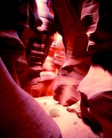
By contrast, slot canyons may be easily missed by a casual observer on a plateau. They do not open widely to the sky; their form and beauty often lie hidden beneath the ground. On the surface, the opening to a slot canyon may appear as a slash, a narrow crevice sliced through the ground. Some slot canyons measure less than 3 feet (1 meter) across at their opening. Yet beneath, from their rim to their floor, the distance may be 100 feet (30.5 meters) or more. Most often, these deep canyons are dark. At times, light from the Sun may filter down, illuminating the sculpted sandstone walls to display their palette of colors.
Slot canyons are cut and scoured by rushing water in the form of flash floods. A flash flood is a flood that occurs after a period of heavy rain, usually within six hours of the rain event. In arid environments where there is little soil to absorb the rain, water quickly runs downhill, gathering volume and speed as it goes. When it runs over the canyon, it descends in a wall of water that blasts through the canyon, eroding the walls and floor. As quickly as the water appears, it disappears, leaving the canyon dry and slightly changed until the next flood.
Canyon: Words to Know
- Convection current:
- The circular movement of a gas or liquid between hot and cold areas.
- Crust:
- The thin, solid, outermost layer of Earth.
- Erosion:
- The gradual wearing away of Earth surfaces through the action of wind and water.
- Flash flood:
- A flood that occurs after a period of heavy rain, usually within six hours of the rain event.
- Igneous rock:
- Rock formed by the cooling and hardening of magma, molten rock that is underground (called lava once it reaches Earth's surface).
- Lithosphere:
- The rigid uppermost section of the mantle combined with the crust.
- Mantle:
- The thick, dense layer of rock that lies beneath Earth's crust.
- Metamorphic rock:
- Rock whose texture or composition has been changed by extreme heat and pressure.
- Plateau:
- A relatively level, large expanse of land that rises some 1,500 feet (457 meters) or more above its surroundings and has at least one steep side.
- Plates:
- Large sections of Earth's lithosphere separated by deep fault zones.
- Plate tectonics:
- The geologic theory that Earth's crust is composed of rigid plates that "float" toward or away from each other, either directly or indirectly, shifting continents, forming mountains and new ocean crust, and stimulating volcanic eruptions.
- Sedimentary rock:
- Rock formed by the accumulation and compression of sediment, which may consist of rock fragments, remains of microscopic organisms, and minerals.
- Slump:
- The downward movement of blocks of material on a curved surface.
- Subduction zone:
- A region where two plates come together and the edge of one plate slides beneath the other.
- Uplift:
- In geology, the slow upward movement of large parts of stable areas of Earth's crust.
Forces and changes: Construction and destruction
Water is a natural force of erosion everywhere on Earth. Surging over a landscape, water will pick up and transport as much material from the surface as it can carry. Aided by gravity and steep slopes, rushing water can carry increasingly larger and heavier objects, including boulders as large as cars. If a river and its surroundings have been elevated from their original position by natural forces within the planet, that river will seek to return to its natural level as quickly as possible. Finding the least resistant path, a river will cut through rock layers. Lowering its floor little by little, the river will take millions of years to carve through the surrounding rock before it reaches the level it seeks. In the process, it creates a canyon.
Uplift and plate tectonics
The formation of a plateau canyon is the direct result of the uplift of the region it occupies. Without regional uplift and the subsequent erosion by a river, there would be no canyons, deep gorges, or other associated landforms. Uplift, however, does not make a canyon. Rather, uplift creates conditions for a river to erode the landscape into the unique and beautiful shape of a canyon.
Uplift occurs because of the tremendous heat forces contained beneath Earth's crust, the rocky outer layer that forms the planet's surface. Deep underground, at Earth's core, temperatures exceed 9,900°F (5,482°C). The planet's interior would melt if the heat energy created by such high temperatures were not released. This is achieved through convection currents, which carry the heat to the surface of the planet.
Convection currents form when rock surrounding the core heats up. Much like a gas or liquid that is heated, this rock expands and becomes less dense (or lighter). It then slowly rises above cooler, denser rock that surrounds it in the mantle, the thick layer of rock that lies between the planet's core and crust. It continues to rise until it reaches the lithosphere (pronounced LITH-uh-sfeer), the rigid uppermost section of the mantle combined with the crust. As the heated rock moves along the bottom of the lithosphere, it loses its heat. As it cools, the rock becomes denser (or heavier) and sinks back toward the core, only to be heated once again. This continuous motion of heated material rising, cooling, and sinking within Earth's mantle forms circular currents called convection currents.
The slowly moving convection currents are able to release their heat energy near the surface of the planet because both Earth's interior and its surface are in motion. Earth's lithosphere is not solid, but is broken into many large slabs or plates that "float" on the asthenosphere (pronounced as-THEN-uh-sfeer), the region of the mantle below the lithosphere that is composed of rocks that are soft like putty. These plates are in constant contact with each other, fitting together like a jigsaw puzzle. When one plate moves, it causes other plates to move. The movement of the plates toward or away from each other is in response to the pressure exerted by the convection currents. The scientific theory explaining the plates and their movements and interactions is known as plate tectonics.
The plates interact with each other in one of three ways: they converge (move toward each other), they diverge (move away from each other), or they transform (slide past each other). The boundaries where plates meet and interact are known as plate margins. At convergent plate margins, the two plates will either crumple up and compress, forming complex mountain ranges, or one plate will slide beneath the other. This latter process is known as subduction, and the region where it occurs is known as a subduction zone.
When a tectonic plate subducts or sinks beneath another, the leading edge of the subducting plate is pushed farther and farther beneath the surface. When it reaches about 70 miles (112 kilometers) into the mantle, high temperature and pressure melt the rock at the edge of the plate, forming thick, flowing magma. Since it is less dense than the rock that typically surrounds it deep underground, magma tends to rise toward Earth's surface, forcing its way through weakened layers of rock. Most often, magma collects in underground reservoirs called magma chambers, where it remains until it is ejected onto the planet's surface through vents called volcanoes. (For further information, see the Volcano chapter.)
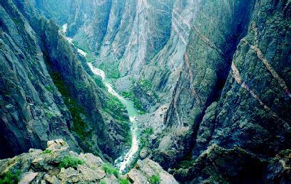
The Painted Wall of the Black Canyon
The Black Canyon in Colorado has been carved by the erosive action of the Gunnison River over the last two million years. The river runs sharply through the canyon, dropping an average of 95 feet per mile (18 meters per kilometer), one of the greatest rates of fall for a river in North America. Aided by the power of this drop, the river has slowly worked its way through the sturdy rock, forming the narrow and steep-sided canyon.
The walls of the Black Canyon are dark gray and composed of schist (pronounced shist) and gneiss (pronounced nice). Both of these are coarse-grained types of metamorphic rock, or rock that was once buried deep within Earth where intense heat and pressure changed its texture and composition. The walls of the canyon are composed of some of the oldest exposed rock in the world. Some of these rocks are nearly two billion years old.
One wall along the canyon appears like marble, with alternating layers of dark and light rock streaking across its surface. This wall, known as Painted Wall, is the highest rock wall in Colorado. From its rim to the river below is a drop of 1,800 feet (550 meters). The light bands in the wall are pinkish and are igneous rock. Igneous rock has been formed by the cooling and hardening of magma, molten rock that is underground (called lava once it reaches Earth's surface). Shortly after the base rock in this wall formed, molten material was forced under great pressure into its cracks and joints, creating the now-famous Painted Wall.
Sometimes the magma plume rises beneath a large, stable landmass and does not break through any cracks or vents. Instead, the pressure
exerted by the magma forces the land to rise upward in one piece. Geologists believe this uplifting process formed the Colorado Plateau about 5 million years ago. Sprawling across southeastern Utah, northern Arizona, northwestern New Mexico, and western Colorado, the Colorado Plateau covers a land area of 130,000 square miles (336,700 square kilometers). This arid region, which was originally close to sea level, was slowly uplifted 4,000 to 6,000 feet (1,220 to 1,830 meters). Once the plateau was raised, the rivers contained on it began to carve thousands of miles of deep, narrow canyons into the plateau's multi-layered rock. Today, even as the Colorado Plateau continues slowly rising, erosion is wearing it down.
The erosive power of water: Rivers and flash floods
The rivers that created the canyons on the Colorado Plateau and elsewhere did so because rivers have a natural tendency to reach a base level. This refers to the point at which the river reaches the elevation of the large body of water, such a lake or ocean, into which it drains. Aided by gravity, a river will downcut or erode its channel deeper and deeper in order to reach the level of its final destination as quickly as possible. The larger the difference in height between the river and its destination, the greater the erosive or cutting force of the river.
Rivers erode because they have the ability to pick up sediments (loose rock fragments) and transport them to a new location. The size of the material that can be transported depends on the velocity, or speed, of the river. A fast-moving river carries more sediment and larger material than a slow-moving one. As it is carried along, the sediment acts as an abrasive, scouring and eating away at the banks and bed of the river. The river then picks up this newly eroded material, which, in turn, helps the river cut even deeper into its channel.
If a river cuts through resistant rock, such as granite, its channel and the canyon it creates will be narrow and deep. If it cuts through weaker material, such as clay or sandstone, its channel and its accompanying canyon will be wide. When cutting through soft rock, a river can undercut its banks, removing a soft layer of material while a harder layer remains above, forming an overhang. The overhang continues to grow as material beneath it is eroded away by the river until the overhang can no longer be supported and collapses into the river. Repeated undercutting can lead to landslides and slumps, creating a V-shaped canyon.
The walls of V-shaped canyons, especially those located in arid environments, are further eroded by rain and ice. In areas where there is little plant cover, dry soil and rock fragments are carried away easily as rain washes over the canyon walls into the river below. When water seeps into cracks between the rocks of the canyon walls and freezes in colder weather, it expands, widening the cracks and pushing the rocks apart. Eventually, the rocks lose their hold and plummet down the canyon wall. On the way down, they often hit and loosen other rocks, creating a rock fall that significantly alters the shape of the canyon.
The Literary Landscape
"Another half mile and I come to a 'dripping spring.' This is a seep high on the canyon wall, two hundred feet above my head, where ground water breaks out between beds of sandstone and slides over the contours of the cliff, nourishing the typical delicate greenery of moss, fern, columbine, and monkeyflower. Below the garden the cliff curves deeply inward, forming an overhang that would shelter a house; at this point the water is released from the draw of surface tension and falls free through the air in a misty, wavy spray down to the canyon floor where I stand, as in a fine shower, filling my canteen and soaking myself and drinking all at the same time."
—Edward Abbey, Desert Solitaire, 1968.
Flash floods erode rocks in similar fashion. On the Colorado Plateau, where slot canyons are primarily found, the dry soil cannot fully absorb

Into Canyon Country: An Epic American Adventure
By the latter part of the nineteenth century, the canyons of the Green and Colorado rivers were among the few remaining unexplored areas on the North American continent. Legends told of a region of giant waterfalls, vicious whirlpools and rapids, and enormous rock cliffs that offered no escape or refuge from the punishment of the rivers. In 1869, a party of nine men led by John Wesley Powell (1834–1902) ventured into this unknown and seemingly terrifying landscape to survey, map, and study the geology of the plateau and canyon country.
Powell, who had served as a major in the Union Army during the American Civil War (1861–1865) and who had lost an arm at the battle of Shiloh, had a lifelong interest in natural history. Drawn by the glamour and mystery of the American West, he set out to explore not only how the region looked but also how its canyons, plateaus, and mountains had been formed.
On May 24, 1869, Powell and his men set off on a river descent of nearly nine hundred miles with no real idea of what terrors and adventures lay before them. Their small vessels plunged through turbulent rapids, foaming waterfalls, and towering canyon walls. Two boats were lost, one member of the team deserted early, and three other members were killed by Native Americans as they gave up on the river journey and attempted to climb out of the Grand Canyon. Despite these hardships, Powell and his remaining men explored the entire reach of the Colorado River, including the Grand Canyon. They were on the river for ninety-two days.
After this epic journey, Powell undertook additional Western adventures, exploring the plateaus of Utah, the Colorado Plateau, and Zion and Bryce canyons. Through his expeditions, he developed the geological idea that the vast processes of uplift and erosion were responsible for the topography or physical features of the canyon and plateau country. In 1895 he published these findings and ideas in Canyons of the Colorado.
the amount of water deposited by sudden, violent storms. Rushing across the sloping landscape in a torrent, the flash flood picks up stones and other debris. Finding cracks in the sandstone on the plateau floor, the debris-laden flood acts like an abrasive, scouring away the relatively soft rock grain by grain. Over millions of years, flash floods and wind have dug deeper and deeper into the sandstone, sculpting the floors and spiraling walls of these unique underground canyons.
Spotlight on famous forms
Antelope Canyon, Arizona
Discovered in 1931 by a twelve-year-old girl, Antelope Canyon (also known as Corkscrew Canyon) lies just outside Page, Arizona, on land owned by the Navajo Nation. Over hundreds of thousands of years, infrequent but often violent water flows have carved the delicate curves and hollows of this slot canyon from hairline cracks in the sandstone. Noted for its photographic beauty, the canyon changes color from violet to red to orange to yellow as light from the Sun filters in from above, illuminating its sculpted sandy walls.
The canyon, a series of passageways of varying widths and heights, is divided into an upper and lower section. The entire canyon measures 5 miles (8 kilometers) in length, and in places it is no more than a few feet wide. Walls of the canyon often rise to a height of 120 feet (36.5 meters).
In August 1997, a severe thunderstorm hit the plateau area around Page, Arizona, dropping a vast amount of water in a short period of time. Since the dry soil in the area could not absorb that amount of water, a flash flood quickly developed and raced toward the normally dry canyon, which was 2,000 feet (610 meters) below the height of the plateau. A group of twelve tourists were trapped in the lower section of the canyon as an 11-foot (3.3-meter) wall of water, carrying tons of mud and debris, washed over them with a force that stripped off their clothes. Only one person survived the deluge.
Colca Canyon, Peru
Colca Canyon (Cañon del Colca) in Peru is one of the deepest canyons in the world. At more than 11,330 feet (3,400 meters), it descends to a depth almost twice that of Arizona's Grand Canyon. The canyon developed from a fault that has been eroded for millions of years by the Colca River, which runs more than 124 miles (200 kilometers) along the Peruvian coast. Looming high in the background of the canyon are snow-capped volcanoes that stand more than 16,400 feet (5,000 meters) in height.
The Inca, the native people who flourished in the area from the twelfth century to the mid-sixteenth century, had carved vaults into the
canyon walls in which they stored grain. The Inca word for these sealed vaults, colcas, gives the canyon its present name. Other Incan artifacts in the canyon include ancient tombs perched high on the vertical canyon walls and terraces, flat and relatively narrow strips of ground constructed on the sloping sides of the canyon in order to grow crops.
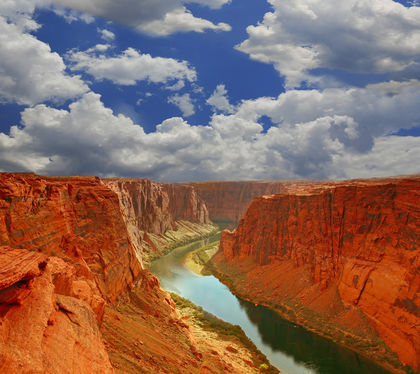
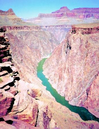
Grand Canyon, Arizona
The Grand Canyon, perhaps the world's most famous canyon, lies at the northwestern edge of Arizona near its borders with Utah and Nevada. Carved by the power of the Colorado River, the canyon stretches for 277 miles (446 kilometers). It begins at Lees Ferry and ends at Grand Wash Cliffs. The Colorado River itself is much longer than the canyon, flowing 1,450 miles (2,333 kilometers) from the Rocky Mountains in Colorado to the Gulf of California in Mexico.
The canyon's depth and width vary. The maximum depth in the canyon is roughly 6,000 feet (1,829 kilometers). Along its South Rim, the average depth from the rim to the river at its bottom is about 5,000 feet (1,524 meters). At its narrowest part, the Grand Canyon is less than 1 mile (1.6 kilometers) across. At its widest, it is 18 miles (29 kilometers). On average, the width of the canyon from rim to rim is 10 miles (16 kilometers).
While the Colorado River was the main source behind its creation, present-day precipitation continues to shape it. The area of the canyon that receives the most precipitation, either in the form of snow or rain, is the South Rim, which receives 15 inches (38 centimeters) of precipitation each year. By contrast, the bottom of the canyon receives only 8 inches (20 centimeters).
Canyon de Chelly and the Anasazi
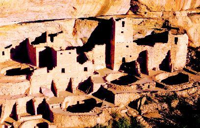
Canyon de Chelly (pronounced CAN-yon de SHAY; Spanish corruption of Navajo word "Tsegi," meaning rock canyon) is a long three-armed canyon located in northeast Arizona. Carved by running streams, the canyon's red sandstone walls are almost vertical, with some rising 800 feet (244 meters). This makes access to the canyon floor difficult. For this reason, the canyon has served as a protective home for more than two thousand years for many ancient and modern Native American tribes.
From about 350 to 1300, the canyon served as a home for the Anasazi. These people, thought to be the ancestors of the modern Pueblo, constructed spectacular dwellings both on the canyon floor and high up the walls on ledges between the sandstone layers. Several hundred different ruins are located in the canyon, ranging from individual small grain storage bins to large housing complexes, including a three-story tower house. On the rock walls throughout the canyon are numerous petroglyphs (rock carvings) and pictographs (rock paintings) dating from this period.
Perhaps because of drought, perhaps because of other, mysterious reasons, the Anasazi abandoned their cliff dwellings after about 1300 and scattered throughout the American Southwest. In the years after, various Native American tribes inhabited the canyon, including the Navajo, who continue to live and farm on the canyon floor.
What makes the Grand Canyon unique are the different rock layers that form its varying slopes and cliffs. Although found elsewhere around the world, the layers are not found in such great variety and with such clear exposure. The canyon is a mere five to six million years old, but the rocks exposed in its walls reveal a more complex history. While rocks at its rim are about 250 million years old, those near the bottom of the canyon are almost 2 billion years old.
Hells Canyon, Idaho and Oregon
The deepest river canyon in North America is Hells Canyon, which straddles the border between Idaho and Oregon. Created by the Snake River, Hells Canyon extends for 110 miles (177 kilometers) along the river's length. In places, the canyon measures over 8,000 feet (2,438 meters) deep. Along a 40-mile (64-kilometer) section of its length, the canyon averages 5,500 feet (1,676 meters) in depth. In Idaho, the highest point along the canyon is the summit of He Devil Peak at 9,393 feet (2,863 meters). In Oregon, the highest point is Hat Point at 6,982 feet (2,128 meters). On average, the canyon is about 10 miles (16 kilometers) wide.
Geologists estimate the canyon was carved by river erosion over nearly six million years; most of this erosion probably took place during the last two million years when melting glaciers, large amounts of rainfall, and spillovers of large lakes increased the power of the river. The erosional activity of the Snake River is still at work today.
Yarlung Zangbo (Tsangpo) Grand Canyon, Tibet
The Yarlung Zangbo River, the highest river above sea level in the world, flows from Tibet through northeast India (where it is known as the Brahmaputra) before joining with the Ganges River in Bangladesh. In Tibet, the river runs across the Tibetan Plateau, the world's highest region with an average elevation exceeding 16,400 feet (5,000 meters). Over millions of years, the river has cut through the weakest part of the plateau, forming the Yarlung Zangbo Grand Canyon. In 1994, Chinese scientists declared the canyon to be the deepest in the world.
The canyon reportedly measures 1,627 feet (496 meters) in length and has an average depth of 16,400 feet (5,000 meters). In places, the canyon drops down to 17,658 feet (5,382 meters). Because of the depth of the canyon, it hosts a range of climates and ecosystems, from glacier environments to tropical rain forests. Very little other information about the canyon is available to the world. Since the region is very remote, and since foreigners are forbidden in many parts of the area, Western scientists have yet to conduct studies of the canyon.
For More Information
Books
Anderson, Peter. A Grand Canyon Journey: Tracing Time in Stone. New York: Franklin Watts, 1997.
Barnes, F. A. Canyon Country Geology. Thompson Springs, UT: Arch Hunter Books, 2000.
Fisher, Richard D. Earth's Mystical Grand Canyons. Tucson, AZ: Sunracer Publications, 2001.
Price, L. Greer. An Introduction to Grand Canyon Geology. Grand Canyon, AZ: Grand Canyon Association, 1999.
Vallier, Tracy. Islands and Rapids: The Geologic Story of Hells Canyon. Lewiston, ID: Confluence Press, 1998.
Web Sites
"Colorado Plateau Province." U.S. Geological Survey. http://wrgis.wr.usgs.gov/docs/parks/province/coloplat.html (accessed on August 14, 2003).
"The Geology of the Grand Canyon." Grand Canyon Explorer. http://www.kaibab.org/geology/gc_geol.htm (accessed on August 14, 2003).
"Grand Canyon National Park: Geologic Story." National Park Service. http://www.nps.gov/grca/grandcanyon/quicklook/Geologicstory.htm (accessed on August 14, 2003).
"Slot Canyons of the American Southwest." The American Southwest. http://www.americansouthwest.net/slot_canyons/index.html (accessed on August 14, 2003).
Wassman, Cliff. Mysterious Places: Hidden Canyons. http://www.mysteriousplaces.com/HiddnCany.html (accessed on August 14, 2003).