Coast and Shore
Coasts mark the area where dry land meets oceans or other large bodies of water. They are one of the most active environments found on Earth. The coastal landscape is ever-changing. It reflects the conflicting processes of erosion (the gradual wearing away of Earth surfaces through the action of wind and water) and deposition (the accumulation and building up of natural materials). It is a landscape that is affected by the interactions of Earth, the Moon, and the Sun.
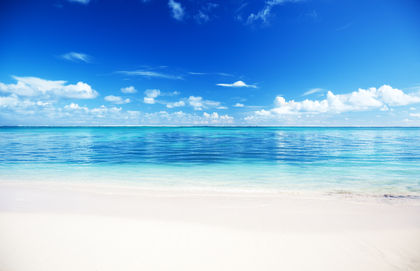
Coasts are among the most beautiful and inspiring landscapes on the planet, whether they are scenes of torrential storms or serene calm. Throughout recorded history, humans have sought to live on or near coasts. Although coasts account for only 10 percent of Earth's land surface, they serve as home to two-thirds of the world's human population.
The shape of the land
Coast and shore, coastline and shoreline, are commonly used in place of each other. Technically, they are different areas along a coastal landscape. The line that marks the boundary between water and land is the shoreline. It constantly fluctuates because of the regular action of waves and tides. The shore is that strip of ground bordering a body of water that is alternately covered or exposed by waves or tides. The boundaries of the shore are marked by the shoreline at its farthest seaward (low tide) and farthest landward (high tide).
Tide is the periodic rising and falling of water in oceans and other large bodies of water in response to the gravitational attraction of the Moon and the Sun upon Earth. Although the Sun is larger than the Moon, the Moon is closer to Earth and, therefore, its gravitational force is approximately 2.2 times greater. The gravitational pull of the Moon creates two types of tides: high and low. A tidal bulge occurs in the oceans on
the side of Earth nearest the Moon; at the same time, a second tidal bulge occurs on the opposite side of Earth. This second bulge forms because the force of the Moon's gravity pulls the solid body of Earth slightly away from the water on Earth's far side. These bulges are high tides. The areas between the tidal bulges experience low tide.
As Earth rotates, the tides move over its surface. It takes approximately 24 hours and 50 minutes for a given point on Earth to make a complete cycle relative to the Moon, and two lunar tidal cycles occur during this time. Thus, the average time between high tides is 12 hours and 25 minutes. This is a generalized explanation of tides. They do not move evenly and predictably over Earth's surface. Variations in the depth of the oceans and the distribution of landmasses combine with other factors to produce highly complex tidal behavior.
The coast and coastline begin where the shore ends at its high tide mark (farthest landward). The line between the coast and the shore at high tide is the coastline. The coast extends landward from the coastline to the first major change in terrain features, which may be miles inland. This could be a highland or a forest or some other type of terrain. Sometimes, the change between the coast and the adjacent terrain is not so distinct.
Coast and shore: Words to Know
- Backshore zone:
- The area of a beach normally affected by waves only during a storm at high tide.
- Backwash:
- The return flow of water to the ocean following the swash of a wave.
- Bar:
- A ridge or mound of sand or gravel that lies partially or completely underwater a short distance from and parallel to a beach; also commonly known as a sand bar.
- Barrier island:
- A bar that has been built up so that it rises above the normal high tide level.
- Bay:
- A body of water in a curved inlet between headlands.
- Beach:
- A deposit of loose material on shores that is moved by waves, tides, and, sometimes, winds.
- Beach drift:
- The downwind movement of sand along a beach as a result of the zigzag pattern created by swash and backwash.
- Berm:
- A distinct mound of sand or gravel running parallel to the shoreline that divides the foreshore zone from the backshore zone of a beach.
- Cliff:
- A high, steep face of rock.
- Coast:
- A strip of land that extends landward from the coastline to the first major change in terrain features.
- Coastline:
- The boundary between the coast and the shore.
- Emergent coast:
- A coast in which land formerly under water has gradually risen above sea level through geologic uplift of the land or has been exposed because of a drop in sea level.
- Erosion:
- The gradual wearing away of Earth surfaces through the action of wind and water.
- Foreshore zone:
- The area of a beach between the ordinary low tide mark and the high tide mark.
- Headland:
- An elevated area of hard rock that projects out into an ocean or other large body of water.
- Longshore current:
- An ocean current that flows close and almost parallel to the shoreline and is caused by the angled rush of waves toward the shore.
- Longshore drift:
- The movement of sand and other material along a shoreline in the longshore current.
- Sea arch:
- An arch created by the erosion of weak rock in a sea cliff through wave action.
- Sea stack:
- An isolated column of rock, the eroded remnant of a sea arch, located in the ocean a short distance from the shoreline.
- Shore:
- The strip of ground bordering a body of water that is alternately covered or exposed by waves or tides.
- Shoreline:
- The fluctuating line between water and the shore.
- Spit:
- A long, narrow deposit of sand or gravel that projects from land into open water.
- Submergent coast:
- A coast in which formerly dry land has been gradually flooded, either by land sinking or by sea level rising.
- Swash:
- The rush of water up the shore after the breaking of a wave.
- Tide:
- The periodic rising and falling of water in oceans and other large bodies of water that results from the gravitational attraction of the Moon and the Sun upon Earth.
- Tombolo:
- A mound of sand or other beach material that rises above the water to connect an offshore island to the shore or to another island.
- Wave crest:
- The highest part of a wave.
- Wave-cut notch:
- An indentation produced by wave erosion at the base of a sea cliff.
- Wave-cut platform:
- A horizontal bench of rock formed beneath the waves at the base of a sea cliff as it retreats because of wave erosion.
- Wave height:
- The vertical distance between the wave crest and the wave trough.
- Wavelength:
- The horizontal distance between two wave crests or troughs.
- Wave trough:
- The lowest part of a wave form between two crests.
Coasts are generally classified into two types: emergent and submergent. Emergent coasts are those in which land formerly under water has gradually risen above sea level through geologic uplift of the land or has been exposed because of a drop in sea level. Currently, sea level around the world is rising by an average of 0.1 inch (0.25 centimeter) per year because glaciers and ice sheets are melting due to global warming (an increase in the world's temperatures thought to be caused, in part, by the burning of fossil fuels and the depletion of the ozone layer). So an emergent coast in the present-day is one that is rising on average more than 0.1 inch (0.25 centimeter) per year. Coasts along Scandinavia, New England, California, and Hawaii are examples of emergent coasts. Submergent coasts are those in which formerly dry land has been gradually flooded, either by land sinking or by sea level rising. Coasts along the southeast Atlantic and the Gulf of Mexico are examples of submergent coasts.
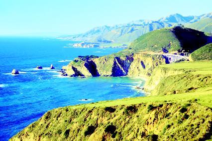
Coastal landscapes may be broadly divided into rocky cliffs and sandy beaches and dunes. All coasts experience a combination of erosion and deposition to varying degrees. Emergent coasts are typically dominated by cliffs or high, steep faces of rock. Because the land is rising in these areas, its landforms are subject to erosion. As waves break against a cliff, certain features are formed, depending on the hardness of the rock. Initially, wave action may cut an indentation, called a wave-cut notch, at the base of the cliff. When the notch becomes larger, rock in the cliff face above the notch loses support and falls into the water where it is broken up by the action of the waves. This process continues and the cliff slowly retreats inland. As it does so, a horizontal bench of rock remains beneath the waves at high tide where the cliff once stood. This feature is called a wave-cut platform. Over time, as the land continues to rise, this platform may be elevated and a new cliff face formed.
The Literary Landscape
"At the foot of this cliff a great ocean beach runs north and south unbroken, mile lengthening into mile. Solitary and elemental, unsullied and remote, visited and possessed by the outer sea, these sands might be the end or the beginning of a world. Age by age, the sea here gives battle to the land; age by age, the earth struggles for her own, calling to her defense her energies and her creations, bidding her plants steal down upon the beach, and holding the frontier sands in a net of grass and roots which the storms wash free."
—Henry Beston, The Outermost House: A Year of Life on the Great Beach of Cape Cod, 1928.
In areas where cliff rock is alternately hard and soft, headlands and bays may form. A headland is an elevated area of hard rock that projects out into an ocean or other large body of water. When soft rock is eroded away between headlands, a curved inlet that holds a body of water known as a bay forms. Because of its location, a headland receives the brunt of
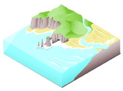
wave attack (wave energy is spread out and weaker in bays). Erosion by water and wind may create distinct features such as sea caves, sea arches, and sea stacks in a headland. Sea caves arise when waves hollow out weak areas of rock in headlands. Waves may then erode the cave through the headland, or caves on either side of the headland may meet. In either case, a sea arch is formed. Erosion of the arch continues until its top portion collapses, leaving a column of hard rock known as a sea stack standing detached from the sea cliff. Continual wave erosion eventually reduces the stack into a stump.
Beaches occur when sand, gravel, and other loose material are deposited by waves along a shore. A beach extends landward from the shoreline at low tide to the shoreline at high tide during storms, when waves are at their highest. In general, a beach is a sandy shore. Beaches are commonly divided into two zones: the foreshore zone and the back-shore zone. The foreshore zone is the area between the ordinary low tide mark and the ordinary high tide mark. The backshore zone is the area normally affected by waves only during a storm at high tide. Behind the back-shore zone may be cliffs, vegetation, or dunes created by winds moving
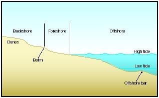
sand from the beach. Commonly separating the two zones is a distinct mound of sand or gravel, called a berm, that runs parallel to the shoreline. It is created by the action of waves and tides.
Wave activity keeps sand and other loose material in constant motion. As a consequence, it can create other features along the shore, such as spits, bars, barrier islands, and tombolos. A spit is a long, narrow deposit of sand or gravel that projects from land into open water. Spits normally form at the mouth of a bay and curve inward. If a spit extends across the entire mouth of a bay, it is called a baymouth bar or bay barrier. A bar, commonly known as a sand bar, is a ridge or mound of sand or gravel that lies partially or completely underwater a short distance from and parallel to a beach. If more sand is deposited on the bar so that it rises above the normal high tide level, the bar becomes a barrier island. Barrier islands range in length from 1.8 to 62 miles (3 to 100 kilometers) and in width from 0.6 to 1.8 miles (1 to 3 kilometers). Separated from the shore by a shallow body of water known as a lagoon, a barrier island often helps protect the shore from the full force of waves. The East Coast of the United States from Massachusetts to Florida is noted for its system of barrier islands. A mound of sand or other beach material that rises above the water to connect an offshore island to the shore or to another island is called a tombolo (pronounced TOM-beh-low).
Forces and changes: Construction and destruction
Coasts and shores are constantly changing. The shoreline moves with the waves and the tides. Rock is eroded away, and gravel and sand are deposited onshore, only to be swept back offshore. Storms batter coasts, and tides flood areas on a daily basis. The premiere forces that shape the coastal landscape, however, are waves.
Breaking waves exert great force. A 10-foot (3-meter) wave can produce a force of 30 pounds per square inch (2.1 kilograms per square centimeter). In addition to the pressure exerted by their impact, waves erode by scouring rock cliffs and other coastal features with rock fragments they carry.
Waves
Most waves get energy and motion from the wind. Wind blowing over the surface of an ocean or other large water body creates friction along that surface, producing tiny ripples. Further pushed by the wind, these ripples combine and increase in size. The size of waves depends on the strength of the winds, the length of the time the winds blow, and the distance of open water across which the winds blow. Large waves may be created by strong winds blowing for long periods of time across large areas of water.
The highest part of a wave is called the wave crest. The lowest part of a wave between two crests is the wave trough. The vertical distance between the wave crest and the wave trough is the wave height. The horizontal distance between two wave crests or troughs is the wavelength. As a wave travels across an ocean or other body of water, the water particles in the wave move in circular patterns, in loops. These loops extend down underneath the surface of the water only one-half the distance of the wavelength. Water beneath that is not disturbed by wave motion. As the wave form advances across the surface, its energy moves forward, not the water itself. The water particles in the loops essentially return to their original position after the wave has passed.
As a wave enters shallow water near a shoreline, the lower loops in the wave begin to drag on the bottom. This causes the wave to slow down. As it does so, its wavelength decreases and its height increases. When the wave can no longer support its height, the wave breaks. Most of the energy it has carried across the ocean is then transferred into the churning, turbulent water known as surf. The powerful surf either crashes into a cliff or runs up a beach. The water moving up the beach is known as swash; the return flow toward the ocean is called the backwash. The speed of the swash is greater than that of the backwash.
Angled waves and drifting sand
Most of the sand and other sediments making up a beach come from weathered and eroded rock from the mainland that is deposited by rivers at the coast. Material eroded from cliffs at the head of a beach itself may
Bay of Fundy
Lying between New Brunswick and Nova Scotia, Canada, is an inlet of the Atlantic Ocean known as the Bay of Fundy. Measuring about 50 miles (80 kilometers) wide where its mouth meets the Atlantic, the somewhat funnel-shaped bay extends about 170 miles (270 kilometers) to the northeast. At its head it splits into two narrow bays, Chignecto Bay and Minas Basin.
The bay is famous for its tidal range. High and low tide alternate in the bay every 6 hours and 13 minutes. With each tide, 24 cubic miles (100 cubic kilometers) of water flushes through the Bay of Fundy, an amount equal to the daily discharge of all the world's rivers. The average range between high tide and low tide of oceans around the world is 3 feet (1 meter). In the Bay of Fundy, the average is 30 feet (10 meters). In Minas Basin, the difference between high tide and low tide can be as much as 52.5 feet (16 meters).
The reason tides rise and fall to such a great extent in the Bay of Fundy is primarily because of its shape. It tapers significantly at its head, and water flowing into the bay rises in response to this constriction. Also, water flows through the entire bay at the same rate that it enters the bay's mouth from the Atlantic Ocean.

form the beach. Beach sand may also contain fragments of smoothed and rounded shells of marine creatures, such as clams. Tropical beaches often consist entirely of shell and coral fragments. Beaches in areas of volcanic activity, such as Hawaii, can be black since the sand is created by the erosion of volcanic rock. Because sand is in constant motion, beaches are often referred to as "rivers of sand." Depending on the action of waves, sand on a beach may travel along the shore hundreds of feet a day.
When waves approach a shoreline, they rarely do so parallel or straight on. Most often, they do so at a slight angle. After a wave breaks, the swash runs up the shore at that slight angle. Because of gravity, however, the back-wash runs straight back to the water directly, without any angle. As a result, the water moves the sand along the beach downwind in a zigzag pattern. This movement is known as beach drift. In addition to beach drift, sand and other sediment is transported downwind along the beach in the longshore current, a current formed by the angled rush of waves that runs close to and almost parallel to the shoreline. The movement of material in this current is known as longshore drift. Over long periods of time, beach drift and long-shore drift may combine to transport sand and other material great distances, eventually forming coastal features such as spits.
Beaches are not fixed features; they are dynamic environments. They expand and contract depending on wave conditions. In winter and during storms, when wind and wave action are more powerful and frequent, erosion often reduces the size of beaches. In summer and during calm weather, gentle waves deposit sand, creating wider beaches. All sandy landforms along a coast—spits, bars, barrier islands, tombolos—are subject to the erosional or depositional action of waves.
Although they do not change as quickly, rocky coasts will eventually change. An irregular coastline of headlands and bays will be straightened by erosion. Wave action will cut away at headlands, quickly break up rock debris and other material, then deposit it along the shoreline of the bay.
Spotlight on famous forms
Cape Cod, Massachusetts
On the East Coast of the United States, just south of Boston, Massachusetts, a large peninsula resembling a flexed arm extends 60 miles (96.5 kilometers) into the Atlantic Ocean (a peninsula is a piece of land that projects from a mainland into a body of water). Considered a premiere vacation resort, Cape Cod features the longest uninterrupted sandy shore in New England.
Cape Cod was formed more than 15,000 years ago by glaciers that covered the area, deposited sediment, then retreated. Ever since, waves
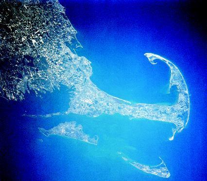
and currents near the shore have shaped and reshaped the peninsula. They continue to do so in the present, transporting sand along the shore to create a variety of coastal landforms, including chains of barrier islands, curved spits, and dunes. Cape Cod's wide sandy beaches are maintained by material that is eroded from cliffs that border the beaches.
During calm summer months, the amount of beach material that is eroded is equal to the amount that is deposited. In winter months, dominated by severe storms from the northeast, erosion takes over. Prevailing waves drag away sand and other material. Overall, land is lost. On average, the cliffs retreat by 3 feet (1 meter) every year. Structures such as walls and jetties built to protect housing and other development from erosion actually increased its rate. To protect this delicate environment from further development, over 43,600 acres (17,440 hectares) along the outer portion of Cape Cod were designated a national seashore in 1961.
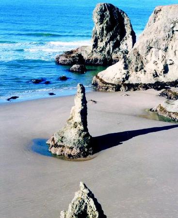
Oregon coast
The coast of Oregon along the Pacific Ocean is noted for sheer cliffs, jagged sea stacks and arches, wave-battered headlands, and long sandy beaches. It is a battleground where land and ocean meet. Wind-driven waves that have traveled 6,000 miles (9,654 kilometers) from Japan—the longest stretch of open ocean in the Northern Hemisphere—crash into the coast unhindered by barrier islands or other features.
This emergent coast has been sculpted by pounding waves that create some of the most violent surf anywhere. The erosive process of the surf takes many years to produce noticeable results, but its force is relentless. Due to erosion, the rocky coast has retreated inland. Evidence of this are the numerous sea stacks jutting from the ocean along much of the coast.
Many of the sea stacks have been given names: Cathedral Rock, Elephant Rock, Face Rock, and the Cat and Kittens. Among the famous sea stacks lining the coast is Haystack Rock, which lies offshore near the town of Cannon Beach. One of the largest free-standing rocks in the world, it towers 235 feet (72 meters) above sea level. It is composed of basalt, a dark, dense volcanic rock. Some 10,000 years ago, Haystack Rock was once part of Tillamook Head (pronounced TIL-ah-muhk), a headland that rises to a height of more than 1,000 feet (305 meters) above sea level.
White Cliffs of Dover, England
Celebrated in literature, song, and film, the White Cliffs of Dover have been an important part of England's natural and social history. Located on the southeast coast of England facing the English Channel, the more than 300-foot-high (91-meter-high) cliffs have provided a natural barrier to foreign invaders throughout history. For English aircrews that flew bombing missions over Europe during World War II (1939–45), the cliffs were the first part of England they saw upon their return. They represented safety.
The cliffs are composed of chalk, which is a particular type of limestone that forms a brilliant white rock formation. Limestone is a sedimentary rock, or rock formed by the accumulation and compression of sediment, which may consist of rock fragments, remains of microscopic organisms, and minerals. Chalk is formed mainly from coccoliths (pronounced COKE-ah-liths), the fossilized remains of tiny, single-celled marine organisms. The coccoliths that form the cliffs were first laid down more than 100 million years ago over a large area of shallow sea, eventually piling into layers.

Before the last ice age some 10,000 years ago, England and France were linked by a chalk landmass. Over time, as sea levels rose, tidal movements eroded the mass, creating the English Channel. Layers of chalk still lie under the seabed of the channel, which has an average depth of 360 feet (110 meters). White cliffs along the French coast match the White Cliffs of Dover. Chalk is a soft rock, and the cliffs naturally erode as waves cut into lower levels while rain seeps into and weakens upper levels. On average, the cliffs are receding at a rate of 0.5 inch (1.3 centimeter) a year.
For More Information
Books
Bird, Eric. Coastal Geomorphology: An Introduction. New York: John Wiley and Sons, 2000.
Davis, Richard A., Jr. The Evolving Coast. New York: W. H. Freeman, 1997.
Haslett, Simon. Coastal Systems. New York: Routledge, 2001.
Hecht, Jeff. Shifting Shores: Rising Seas, Retreating Coastlines. New York: Atheneum, 1990.
Web Sites
"Coastal and Marine Geology Program." U.S. Geological Survey. http://marine.usgs.gov/index.html (accessed on August 14, 2003).
"The Coastal Scene: Oceanography from the Space Shuttle." Goddard Space Flight Center, National Aeronautics and Space Administration. http://daac.gsfc.nasa.gov/CAMPAIGN_DOCS/OCDST/shuttle_oceanography_web/oss_4.html (accessed on August 14, 2003).
"Park Geology Tour of Shoreline Geology." National Park Service, Geologic Resources Division. http://www2.nature.nps.gov/grd/tour/coastal.htm (accessed on August 14, 2003).
"Where Parks Meet the Sea." U.S. Geological Survey and the National Park Service. http://www2.nature.nps.gov/grd/usgsnps/sea/sea.html (accessed on August 14, 2003).
it really helped me a lot with my stidies.
good luck,!
It helped me alot with my studies as well.
I've had a test already on this and I used this page for help and I got 100% on it!
This Article Rocks!!!
What types of coastlines found in the Pacific??
Kind Regards,
Terri (so little time, so much to know) Moore
THIS IS GREAT FOR MY PROJECT THANK YOU!!!
but where is the name of the author of that nice essay ?
thanks alot