Dune and Other Desert Features
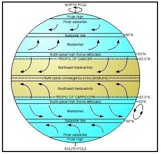
Desert environments have fascinated humans throughout the ages. Covering approximately one-third of Earth's land surface, these arid (dry) landscapes receive less than 10 inches (25 centimeters) of rain per year and support only limited plant and animal life. Deserts may be hot, located primarily between the tropic of Cancer and the tropic of Capricorn, two parallel lines of latitude lying one-quarter of the way from the equator to the North and South Poles, respectively. Deserts may also be cold, located in polar regions where the mean temperature during the warmest month is less than 50°F (10°C). Most deserts on the planet lie within the Tropics (also called the Torrid Zone).
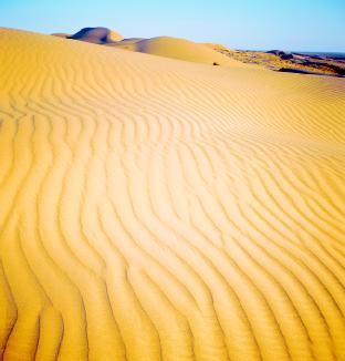
What differentiates deserts from other ecosystems (communities of plants and animals interacting with their environment) around the world is not only extreme climate but the landforms scattered across their surfaces. For many people, these fantastic forms define the desert landscape. Miles upon miles of rolling dunes, like waves on a sea suddenly stopped, dominate popular images of deserts in books and motion pictures. Yet, only one-fifth of all desert surfaces are covered with sand. Alluvial fans, arroyos, blowouts, desert pavement, oases, playas, yardangs: These are but a few of the many features that combine to create the spare desert landscape.
The shape of the land
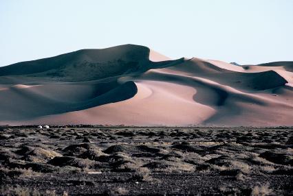
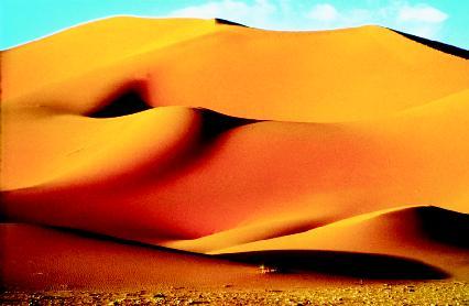
Although dunes, wind-blown piles of sand, make up only 20 percent of the total desert landscape, these landforms may cover thousands of square miles and reach heights of up to 1,640 feet (500 meters). Dunes occur in many shapes, but common to all dunes is the contrast between the gentle slope of the windward side (the side facing into the wind) and the steep slope of the leeward side (the side facing away from the wind). The leeward side is known as the slip face of the dune. Geologists,
scientists who study the origin, history, and structure of Earth, have classified the most common dune forms into five types: barchan, parabolic, linear, transverse, and star.
Dune types
A barchan (pronounced bar-KAN) dune, sometimes known as a crescentic dune, is a crescent or U-shaped dune that has its "horns" or tips pointing downwind or away from the wind. Barchans arise where sand supply is limited, where the ground is hard, and where wind direction is fairly constant. They form around shrubs or larger rocks, which act as anchors to hold the main part of the dune in place while the tips migrate with the wind. Barchan dunes occur widely in deserts around Earth.
A parabolic dune is similar in shape to a barchan, but its tips point into the wind. Its formation is also influenced by the presence of some type of obstruction, such as a plant or a rock. Just the opposite of a barchan, a parabolic is anchored at its tips by the obstruction, which acts to block the wind, while its main body migrates with the wind, forming a depression between the tips. Because of this formation, parabolic dunes are also known as blowout dunes.
A linear, or longitudinal, dune is one that forms where sand is abundant and cross winds converge, often along seacoasts where the winds from the sea and winds from the land meet and push the sand into long lines. These high, parallel dunes can be quite large: Scientists have recorded linear dunes reaching 655 feet (200 meters) in height and 62 miles (103 kilometers) in length. The crests or summits of linear dunes are often straight or slightly wavy.
A transverse dune also forms where sand supply is great. This dune is a ridge of sand that forms perpendicular to the direction of the wind. The slip face of a transverse dune is often very steep. A group of transverse dunes resembles sand ripples on a large scale.
Dune and other desert features: Words to Know
- Abrasion:
- The erosion or wearing away of bedrock by continuous friction caused by sand or rock fragments in water, wind, and ice.
- Atmospheric pressure:
- The pressure exerted by the weight of air over a given area of Earth's surface.
- Bajada:
- Several alluvial fans that have joined together.
- Basin:
- A hollow or depression in Earth's surface with no outlet for water.
- Compression:
- The reduction in the mass or volume of something by applying pressure.
- Crest:
- The highest point or level; summit.
- Deflation:
- The lowering of the land surface due to the removal of fine-grained particles by the wind.
- Ecosystem:
- A system formed by the interaction of a community of plants, animals, and microorganisms with their environment.
- Eolian:
- Formed or deposited by the action of the wind.
- Erg:
- A vast area deeply covered with sand and topped with dunes.
- Erosion:
- The gradual wearing away of Earth surfaces through the action of wind and water.
- Gully:
- A channel cut into Earth's surface by running water, especially after a heavy rain.
- Leeward:
- On or toward the side facing away from the wind.
- Saltation:
- The jumping movement of sand caused by the wind.
- Silt:
- Fine earthy particles smaller than sand carried by moving water and deposited as a sediment.
- Slip face:
- The steeply sloped side of a dune that faces away from the wind.
- Surface creep:
- The rolling and pushing of sand and slightly larger particles by the wind.
- Ventifact:
- A stone or bedrock surface that has been shaped or eroded by the wind.
- Windward:
- On or toward the side facing into the wind.
A star dune forms where there is plentiful sand and many dominant winds come from various directions. As its name implies, a star dune resembles a star with its many arms pointing out in different directions. The crests on the arms slope upward, meeting to form a point in the middle

of the dune similar to that of a pyramid. The largest and highest dunes are star dunes.
All the five major dunes can be further categorized into simple, compound, and complex types. When they occur in their original states, all dunes are simple. When a smaller dune forms on top of a larger dune of a similar type and orientation to the wind, the entire structure is known as a compound dune. When a smaller dune forms on top of a larger dune of a different type, it is known as a complex dune.
Alluvial fan
Water may be scarce in a desert environment, but when it does appear, such as in a brief and violent rainstorm, it can change the landscape quickly and dramatically. Precipitation that falls in higher elevations in deserts flows rapidly down to flat areas through canyons, valleys, and other narrow, confined channels. Because most desert soil lacks plants and their root systems to help hold the soil together, the flowing water easily picks up any loose material in its path. The faster the water flows, the larger the pieces of material it is able to pick up and carry along.
When the rushing water finally reaches a plain or flat area, it loses power since gravity is no longer helping it flow down a steep slope. As it slows, the water is unable to carry the sediment—gravel, clay, sand, and silt—it picked up on its way downhill. Large rocks and other heavy material are deposited first at the base of the canyon, followed by other material in decreasing size. No longer confined to a narrow channel, the water spreads out the farther it moves away from the base of the canyon. The finest material it carried is deposited at the outer edge. When the water evaporates, the sediments remain behind. Over time, as more water flows onto the plain, more sediment is deposited, and a wide, fan-shaped pile known as an alluvial (pronounced ah-LOO-vee-al) fan forms. When two or more alluvial fans merge on a plain to create a broad, sloping surface, they form a bajada (pronounced ba-HA-da; Spanish for slope).
Arroyo
An arroyo (pronounced ah-ROY-oh) is another desert landform sculpted by the action of water. Sudden heavy downpours cut channels in the desert floor, often in canyons or other low-lying areas. These fast-moving but short-lived streams create deeper channels or gullies with steep sides and an almost flat bed or bottom. Just as quickly as the water appears, it disappears in the normally dry desert environment. What remains is an arroyo, a dry watercourse with a floor that is often gravel-strewn.
Blowout
Following water, wind is a major cause of erosion (the gradual wearing away of Earth's surfaces through the action of wind and water) in the desert. Without plants and their anchoring roots, loose desert soil is moved easily by near-constant blowing winds. Blowouts, also known as deflation basins or hollows, are depressions made in sand or light soil by
strong wind action. These low spots may range in size from several feet to several miles in diameter. Blowouts can form around desert plants with hardy roots or around rock structures, leaving them perched atop a column as more and more sand or soil is blown away.
Desert pavement
The strength of the wind determines the amount and type of material it removes from the desert floor. As the wind increases in strength, it is able to move and transport more and larger particles. Initially, very fine particles are moved by the wind. As more and more of these types of particles are removed, the surface of the land lowers in elevation. This action, known as deflation, continues until what remains on the desert floor is a layer of closely packed pebbles and rocks too heavy for the wind to move. Settled and wind-polished, the entire surface is called desert pavement or reg. The older the pavement, the smoother and flatter it appears, like a highly worn cobblestone street. Younger pavement areas are coarser, less eroded by the action of the wind.
Oasis
Beneath Earth's surface, water fills the pore spaces and openings between rocks. This water that seeped through the soil, drawn downward by gravity, is known as groundwater. At a certain level below ground, all openings between the rocks are completely filled with groundwater. The upper surface of this area is called the water table, and it is found everywhere beneath Earth's surface. Even beneath desert regions, there is water.
Groundwater hardly ever reaches the desert surface, but when it does, it can transform the stark landscape into a fertile haven thriving with many species of plants and animals that otherwise would not exist in that hot, dry space. This green area, existing like an island in a sand sea, is an oasis (pronounced oh-AY-sis; plural form is oases). Many oases are artificial ecosystems, created by people living in the desert using large pipes to tap into the groundwater to bring it to the surface. A few, though, are the result of natural forces. These oases are centered on springs that have been exposed because of blowouts and other erosive actions by the wind that have lowered the land surface.
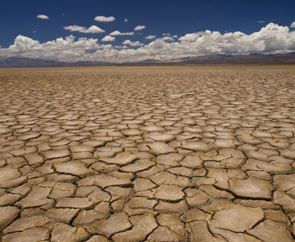
Playa
Permanent water bodies are rare in deserts. When precipitation does occur in a desert, it often runs down steep hills to form temporary surging streams in low-lying areas before evaporating or sinking into the ground. When the water falls on fairly flat areas, it may collect in a basin or other slightly depressed area, forming a small lake that may last for a while before the water evaporates or is absorbed. What remains after the water is gone are the sediments it collected as it flowed along the desert surface. Those sediments, mostly clay, silt, and various salts, form a level, broad, cracked surface called a playa (pronounced PLY-uh; Spanish for beach). When water is still present, these bodies are called playa lakes.
Although they are very rare, permanent desert lakes do exist. Two examples are the Great Salt Lake of Utah and the Dead Sea of Israel and Jordan. The Great Salt Lake is all that remains of ancient Lake Bonneville, which was ten times the size of the Great Salt Lake, while the Dead Sea was once part of the Mediterranean Sea.
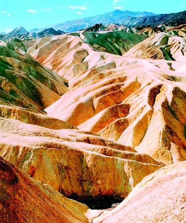
Yardang
Among the most striking desert landforms created by the action of the wind are yardangs (from the Turkic word yar, meaning "steep slope"). A yardang is a wind-sculpted, streamlined ridge that can stretch for over one mile in length and 100 feet (30 meters) in height. It forms when strong winds blowing primarily in one direction remove all sand in an area down to the bedrock (solid rock beneath the sand). If the bedrock is slightly soft or porous, winds will erode the bedrock, sandblasting hollows out of the soft parts of its surface. Over a vast amount of time, winds cut away enough material to leave a sleek-shaped ridge, similar in shape to the bottom of an overturned boat, that runs parallel to the wind.
Forces and changes: Construction and destruction
The desert landscape is shaped primarily by two forces: wind and water. Through three main actions, wind sculpts the face of the desert landscape. It is the more prevalent force, but water is the more powerful. Though its appearance is limited, water is the primary agent of erosion in the desert.
To understand the actions of wind and water in forming desert land-forms, it is necessary to understand first how circulating air patterns in Earth's atmosphere create conditions that bring about desert environments. As mentioned earlier, the majority of the planet's deserts are located in two horizontal belts near the equator, where the Sun is closest to Earth. In this region, the Sun heats the air, causing it to rise. As the air rises, low air pressure develops beneath it. As the air rises even higher in the atmosphere, it cools, and moisture in the cooling air begins to condense and fall as rain (this explains why most rainforests are also found near the equator). When the cool air reaches the top of the troposphere, the lowest 10 miles (16 kilometers) of Earth's atmosphere, it can rise no further and begins to move toward the poles, cooling even more as it travels northward and southward.
At about 30° latitude north and south of the equator, the cool, dry air descends to Earth's surface. In the process, the air becomes strongly heated
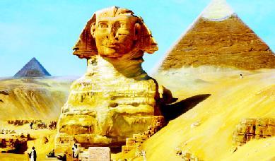
Was the Sphinx Originally a Landform?
In 2001 Farouk El-Baz, Boston University professor and director of the university's Center for Remote Sensing, published a paper in which he suggested that the pyramids and the Great Sphinx located on Egypt's Giza Plateau were based on natural landforms found in the eastern Sahara Desert. El-Baz pointed out that the landscape of the Nile River valley features coneshaped hills that have lasted many years because their shape forces the strong winds in the area upward, preventing the wind from eroding them or wearing them down. The pyramid builders, El-Baz believes, would have looked to these landforms in their quest to build lasting structures.
Extending his theory even further, El-Baz asserted that the Great Sphinx, the enormous sculpture with the head of a man and the body of a reclining lion, might even have been carved by ancient Egyptians in 2500 B.C.E. from an existing desert landform. He cited the works of early twentieth-century explorers and geologists that described wind-eroded yardangs in northwestern China and southwestern Egypt as "sphinx-like" or "lionlike." El-Baz believes the head of the sphinx was an existing yardang (a wind-sculpted ridge) the Egyptians reshaped. They then formed the body, which sits in a hollow or depression, by digging out the naturally occurring limestone on the plateau around it.
due to compression caused by atmospheric pressure (atmospheric pressure increases closer to the planet's surface). During its descent, the warming air pushes the air below it back toward the equator, since air flows always move toward areas of low pressure. Passing over land on its way back to the equator, the now heated, dry air evaporates any moisture in the air, creating dry regions or deserts.
These wind patterns explain the formation of many of the world's deserts in the area between 15° and 35° latitude north and south of the equator. Although much weaker, similar atmospheric circulation (with heated, dry air evaporating moisture as it moves over Earth's surface) occurs over both poles, creating polar deserts. While heated because of compression by the atmosphere, the air over the polar regions is not as warm as in equatorial regions simply because the Sun is farther away from Earth in these areas. Polar deserts, however, are similar to hot deserts because they have very low humidity and precipitation levels.
The topography (physical features) of Earth in combination with atmospheric pressure creates other deserts around the planet. Rain-shadow deserts are those that lie on the leeward side of mountain ranges located near coasts. As moisture-laden air flows inland from an ocean and encounters a mountain range, it is pushed upward. Cooling as it rises, the air begins to lose its moisture on the windward side of the mountain range through rainfall. Once on the leeward side, in the "shadow" of the mountain range, the air has little moisture left. Heated by compression as it descends, the warm, dry air forms deserts in the slope of the range. All deserts in North America are formed by this action.
The Literary Landscape
"What land can equal the desert with its wide plains, its grim mountains, and its expanding canopy of sky! You shall never see elsewhere as here the dome, the pinnacle, the minaret fretted with golden fire at sunrise and sunset; you shall never see elsewhere as here the sunset valleys swimming in a pink and lilac haze, the great mesas and plateaus fading into blue distance, the gorges and canyons banked full of purple shadow. Never again shall you see such light and air and color."
—John C. Van Dyke, The Desert, 1901.
The force of wind
Wind is a common element in desert environments because the Sun heats air near the desert surface, causing it to rise. The warmed air is then replaced by cooler air, which is then heated and rises. This constant cycle of air warming, rising, and being replaced results in winds. The lack of desert vegetation also allows winds to blow unrestricted. Strong and unchecked, wind has the ability to transport, erode, and deposit material in the desert, creating and modifying its landforms. The work of the wind
is known as eolian (pronounced ee-OH-lee-an; from Aeolus, the god of the winds in Greek mythology).
The wind moves like a fluid, like water, and it can erode only if it is strong enough. Very often, it merely transports material. Very small particles, measuring less than 0.01 inch (0.02 centimeter) in diameter, can be picked up easily by desert winds and carried aloft for hundreds or thousands of miles. Suspended on air currents, whirling high in the atmosphere, dust from Africa's Sahara Desert sometimes crosses the Atlantic Ocean before landing in the west Atlantic and Caribbean Sea. On the other hand, sand particles, which typically measure 0.01 to 0.25 inch (0.02 to 0.64 centimeter) in diameter, can be carried only by extremely strong winds. Silt and other very small-sized particles fill the air during dust storms, but these and most other wind-borne grains are too small to cause erosion or sandblasting of major landforms that stand high above the desert floor.
Scientific experiments have shown that wind-blown sediment causes the most erosion at a height of no more than 10 inches (25 centimeters). Indeed, erosion of the landscape by the wind takes place mainly on the ground, where the wind removes fine-grained particles causing deflation (lowering of the land surface due to the removal of particles by the wind). This continued action leads to blowouts and desert pavement. Any stone or part of the bedrock that has been abraded or shaped by the wind is known as a ventifact (artifact of the wind). A yardang is one large desert landform that is sculpted by the wind though deflation and abrasion.
The wind transports larger-grained sediments, particularly sand, through the process called saltation. While light enough to be picked up by strong wind, sand is too heavy to remain suspended in the air. As a result, it is moved along Earth's surface by the wind through a series of short jumps and bounces. The vast majority of sand transported in this way travels within 2 feet (0.6 meter) of the ground. As saltating particles crash to the ground, they can dislodge and move slightly larger particles, such as small pebbles. The sliding and rolling movement of these particles is called surface creep.
Cultural Landforms
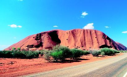
In the barren Great Sandy Desert in Australia's Northern Territory a red sandstone monolith (tall block of rock), the world's largest, rises 1,143 feet (348 meters) above the surrounding flat sandy plain. Ayers Rock, known as Uluru to the Anangu Aboriginals, the native people of the region, is an inselberg, a prominent steep-sided hill composed of strong, solid rock that sits isolated in a desert plain. Like other inselbergs, Ayers Rock's rounded appearance is caused by weathering in which its durable surface has been eroded in successive layers, like the peeling of an onion skin.
Estimated to be between 400 and 600 million years old, the monolith measures about 1.5 miles (2.4 kilometers) wide and 2.2 miles (3.5 kilometers) in length. Geologists believe that two-thirds of the rock, measuring some 3.7 miles (6 kilometers), lies beneath the desert floor. The rock mound's changing colors as the Sun moves over it, from gray to gold to red to purple, are due to minerals like feldspar contained in the sandstone. The famous red color is also a direct result of iron in the sandstone, which oxidizes or rusts.
Uluru has deep cultural significance for the Anangu. They consider it a sacred place, having been formed by supernatural beings who crossed the Australian landscape, creating various landforms in their wake. In 1985, the Australian government returned Uluru National Park, which contains the monolith, to its original owners. The Aboriginals then leased the area to the Australian National Parks and Wildlife Service.
Sand is finally deposited when the wind encounters some type of an obstacle: rocks, vegetation, or a manmade structure. As wind passes over an obstacle, the wind's velocity, or speed, increases. Once on the other
side of the obstacle, its velocity decreases and any sand or particles it was transporting drop out to begin forming a mound. When there is a steady supply of sand carried by a steady wind that comes in contact with an obstacle or irregularity in the flat ground surface, a sand dune forms.
The type of dune formed is influenced by the direction and strength of the wind, the amount of sand it carries, and the shape of the land. All dunes have a gently sloping windward face and a steeply sloping leeward or slip face. The slope of the windward face is usually between 10° and 20°, while the slip face has a slope of a much greater angle, about 32°. The windward face is usually hard packed and smooth, cut occasionally by minor grooves. The slip face is soft and unstable.
As wind passes over the windward face of a dune, it moves sand along the surface through sliding movements and saltation (the jumping movement of sand caused by the wind). Once over the crest of the dune, sand flows down the slip face. This action—the eroding of sand on the windward face and the deposition of sand on the slip face—causes the dune to move or migrate with the wind like a slow wave.
It is rare that a single dune forms in an area. Most often, dunes form in groups called fields on broad flat lands where winds blow steadily and sand is plentiful. Far-reaching fields, such as those in the Arabian Desert in eastern Egypt, are called sand seas or ergs (Arabic for ocean).
The force of water
Deserts are defined by their lack of water, both rainfall and free-standing. Coastal deserts may experience one or two rainfalls a year; those farther inland may receive one or two a decade. Though rare, desert rainfalls are often heavy storms lasting mere minutes or a few hours. The Sahara Desert, which normally receives less than 5 inches (12.7 centimeters) of rain a year, once received 1.7 inches (4.4 centimeters) in three hours.
Water is a natural force of erosion everywhere on the planet, but especially so in the desert. When raindrops strike bare ground that is not protected by vegetation, they loosen particles of soil, spattering them in all directions. During heavy rains on sloped surfaces, the dislodged soil is carried off in a flow of water.
With little vegetation or organic-rich soil to absorb the water, the desert landscape is quickly eroded as the torrent of water surges over it, picking up and transporting as much sediment as it can carry. What takes desert wind a year to accomplish, water surpasses in a day or two. Because of the unexpected, and often violent, nature of rainfall in the desert, more people die of drowning than of thirst in that arid environment.
Aided by gravity and steep slopes, rainfall on high desert elevations flows down over the surface as sheets, picking up sediments along the way. Finding natural depressions, such as gullies and canyons, water continues to race along, gaining speed and power as it is confined and flows downward. Increased velocity allows the water to pick up more and larger sediments and rock debris, eroding them and the surface below as it rushes along. Often clogged with so much debris, the water can resemble a mud-flow (a thick mixture of water, mud, and other surface fragments).
Arroyos, dry streambeds created by previous rains, again fill with water. When an arroyo finally opens onto a flat, broad plain, the rushing water flows out and drops its load of sediments, forming a new alluvial fan. In other areas, basins or depressions in the desert floor fill with water, forming playa lakes that soon evaporate, leaving a dry, cracked, salty lake bed that will remain until the next rain.
Spotlight on famous forms
Algodones Sand Dunes, California
The Algodones Sand Dunes, also known as the Imperial Sand Dunes, stretch more than 40 miles (64 kilometers) northward from the U.S.-Mexico
border along the eastern edge of the Imperial Valley agricultural region in southeastern California. The dune system, the largest in the state and one of the largest in the country, formed approximately ten thousand to twenty thousand years ago. Some geologists believe that blowing sands from Lake Cahuilla (pronounced kah-WEE-ah), an ancient freshwater lake located just west of the present-day area, helped create the dunes.
The dune system, which lies within the Sonoran Desert, varies in width from 5 to 8 miles (8 to 12.9 kilometers). Prevailing westerly winds cause the dunes to migrate to the southeast at a rate of approximately 1 foot (0.3 meter) a year. The crests of the largest dunes often reach 300 feet (91 meters) above the surrounding landscape. With summer temperatures rising above 110°F (43°C) and annual rainfalls of less than 2 inches (5 centimeters), the system supports very little vegetation. Often, the dunes stretch uninterrupted by any life for miles, a vast pile of pure golden sand against a dry blue sky. This unspoiled environment has been used as the set for many films, including Star Wars (1977) and Return of the Jedi (1983).
This ancient and fragile dune system is threatened by uncontrolled and intense use of off-road vehicles. The U.S. Bureau of Land Management has set aside over 70,000 acres (28,000 hectares) of the dune system as a protected environment free from such recreational activity.
Lut Desert yardangs, Iran
The Lut Desert or Dasht-e Lut ("Desert of Emptiness") lies in Iran's southeastern province of Kerman. The great sand and stone desert covers an area almost 300 miles (480 kilometers) in length and almost 200 miles (320 kilometers) in width. Among the driest places on the planet, it receives an average of only 1.2 inches (3 centimeters) of rain a year. Certain areas of the desert reportedly receive no rain. Extremely barren, the desert contains the only region free from any life, including the existence of bacteria, on Earth.
In the western part of this desolate environment lie some of the world's most prominent yardangs. Rising up to 282 feet (80 meters), these streamlined ridges have been carved by the wind out of the silty clay and sand lining the desert floor. Lying parallel to the prevailing north-north-west winds, the yardangs are separated by troughs measuring 330 feet (100 meters) or more. The crests or summits of the largest of these yardangs are rounded or flat; all others are narrow. Geologists have found no evidence that water has played any significant part in their creation and continued erosion.
Racetrack Playa, Death Valley, California
Death Valley, located in eastern California, lies between the Panamint Mountains on the west and the Amargosa Range on the east. A desert basin, much of which lies below sea level, Death Valley contains a small pool, Badwater, that is the lowest point in the Western Hemisphere: 282 feet (86 meters) below sea level. Death Valley is also the hottest place on the North American continent, with summer temperatures often exceeding 120°F (49°C). Rainfall seldom measures more than 2 inches (5 centimeters) a year.
Located within Death Valley National Park is a playa known as Racetrack Playa. Like other dry lakebeds in other deserts around the world, Racetrack Playa temporarily fills with water during heavy storms, collecting the runoff from nearby mountain slopes. Under the hot Sun, the thin sheet of water quickly evaporates, leaving the almost perfectly flat clay surface of the playa dry and cracked in a mosaic pattern.
What makes Racetrack Playa unique, and world-famous, are the rocks that slide across its surface and the mystery behind their movements. Periodically, rocks from rock formations around the playa break off and drop
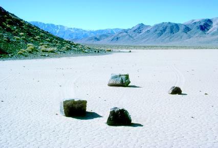
to the floor of the dry lakebed. Some of these rocks are actually boulders, weighing up to 705 pounds (320 kilograms). Instead of being concentrated in one area, these rocks are scattered across the playa, with grooved trails stretching behind them, some straight, some curved, some extending as long as 2,896 feet (880 meters). Until recently, geologists have been at a loss to explain the possible reason behind their movement.
Now, geologists believe the rocks slide because of a combination of water and wind. After the playa becomes wet with rainwater, and before the water completely evaporates, the surface of the clay-filled lakebed is extremely slick. Winds, channeled by low points in the surrounding mountains, stream across the playa in natural wind tunnels. Some of the winds reach 70 miles (113 kilometers) per hour. Geologists believe the winds are strong enough to set even the heaviest boulders sliding across the slippery playa surface.
Sahara Desert dunes, North Africa
The Sahara Desert, the world's largest, spreads across the upper third of the African continent from the Atlantic Ocean to the Red Sea. From north to south, it extends about 1,200 miles (1,930 kilometers). In all, it covers about 3.5 million square miles (8.8 million square kilometers), an area almost as large as the United States. Countries that fall at least partly within the Sahara include Morocco, Algeria, Tunisia, Libya, Egypt, Mauritania, Mali, Niger, Chad, and Sudan.
The desert's landforms, which tend to have a golden color, range from rocky mountains and wind-eroded highlands (known as hammada) to rock-filled plains (known as reg) and deep, narrow canyons. Oases dot the landscape, providing native people, plants, and animals the chance to exist.
Shuttles on the Playa
Edwards Air Force Base, home of the U.S. Air Force Test Center, is located in the Mojave Desert about 100 miles (161 kilometers) northeast of Los Angeles, California. Adjacent to the main Edwards complex lies a 44-square-mile (114-square-kilometer) playa known as Rogers Dry Lake. For more than forty years, the dry lakebed has been used for emergency and test landings of experimental and standard aircraft. Since 1977, the playa has served as the landing site for many space shuttle tests and operational flights.
Formed some 2.5 million years ago during the Pleistocene Epoch, Rogers Dry Lake is the largest geological formation of its kind in the world. Its extremely flat, hard surface of parched clay and silt undergoes a cycle of renewal each year. Desert winds sweep water from winter rains back and forth across its surface, smoothing it out to an almost glassy flatness. Its surface is so perfect, in fact, that runways can merely be painted on the ground. There are seven outlined runways on the playa, the longest of which extends 7.5 miles (12 kilometers).
Many aviation milestones have been reached on the playa. In 1947, U.S. Air Force Captain Chuck Yeager became the first person to break the sound barrier when he piloted the rocket-powered Bell X-1 over the playa to a speed of Mach 1.06, exceeding 662 miles (1,065 kilometers) per hour at 40,000 feet (12,192 meters) elevation.
Just thirty years later, the U.S. space shuttle Enterprise successfully completed a landing and roll out on Rogers Dry Lake after it had been launched from the back of a 747 aircraft. This, along with four subsequent tests, demonstrated the soundness of the shuttle design. In the early days of the space shuttle program, most shuttles landed on the playa. Present-day shuttles continue to land there if weather conditions are poor at the Kennedy Space Center in Cape Canaveral, Florida, home to the space shuttle program.
Overshadowing all these distinct landforms, however, are the great Saharan sand seas or ergs, which compose 15 percent of the desert. Confined to large basins, the ergs are separated by plateaus and low mountain ridges. Dunes in the ergs can soar to 1,000 feet (305 meters). While some dunes in

the Sahara are stationary, others are in constant motion. As they migrate with the wind, dunes may emit strange singing or booming sounds as the sand grains move against each other, tumbling down the slip faces of the dunes.
It is not uncommon for dune fields in the Sahara to stretch for hundreds of miles without a break or any sign of life. The Libyan Erg, located near Egypt, holds the greatest mass of dunes on Earth. It covers more than 200,000 square miles (518,000 square kilometers), an area almost as large as France.
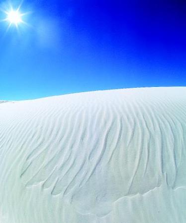
White Sands National Monument, New Mexico
Of North America's four deserts—the Chihuahuan, the Great Basin, the Mojave, and the Sonoran—the Chihuahuan is the farthest east and the farthest south. Extending north from Mexico, the desert reaches into
southern New Mexico, southeastern Arizona, and southwestern Texas. At the desert's northern end in New Mexico lies a mountain-ringed valley called the Tularosa Basin. Covering 275 square miles (712 square kilometers) of this basin is a dune field unlike any other in the world.
The glistening white dunes in this basin form the largest pure gypsum dune field in the world. Most sand on the planet is made of quartz, one of the most abundant rock-forming minerals found in Earth's crust. Gypsum is a mineral composed of calcium sulfate (calcium, sulfur, and oxygen) and water. It rarely forms sand because it is soluble (can be easily dissolved) in water.
Precipitation that falls on the mountains surrounding Tularosa Basin, averaging 8 inches (20 centimeters) a year, dissolves gypsum contained in the rocks. The flowing water then carries the gypsum and other sediments down into the basin into a playa, Lake Lucero, which lies a few miles southwest of the dune field. With no watercourse, such as a river, to carry the water away, it evaporates, leaving the now-crystallized gypsum on the surface of the dry lakebed. Strong southwest winds blowing across the playa transport the gypsum to the nearby dune field. Quite dynamic, many dunes in the field migrate with the wind, moving northeast as much as 30 feet (9 meters) a year.
A large portion of the dune field, 115 square miles (298 square kilometers), is enclosed in the White Sands National Monument, which helps preserve the ecological integrity of the region. Surrounding the park is the White Sands Missile Range, a military base used for testing various weapons. Within the base lies Trinity Site, an area where the first atomic bomb was detonated on July 16, 1945.
For More Information
Books
Gallant, Roy A. Sand on the Move: The Story of Dunes. New York: Franklin Watts, 1997.
Lancaster, Nicholas. The Geomorphology of Desert Dunes. New York: Routledge, 1995.
Web Sites
"Desert Geologic Features." Desert USA. http://www.desertusa.com/mag99/sep/papr/desfeatures.html (accessed on August 26, 2003).
"Deserts: Geology and Resources." USGS. http://pubs.usgs.gov/gip/deserts/ (accessed on August 26, 2003).
EOSC 110: Desert Photos. http://www.eos.ubc.ca/courses/eosc110/fletcher/slideshow/deserts/deserts.html (accessed on August 26, 2003).
Geomorphology of the Sonoran Desert. http://alic.arid.arizona.edu/sonoran/Physical/geomorphology.html (accessed on August 26, 2003).
Park Geology Tour of Sand Dune Parks. http://www.aqd.nps.gov/grd/tour/sanddune.htm (accessed on April 2, 2003).
"Sand Dunes." Desert USA. http://www.desertusa.com/geofacts/sanddune.html (accessed on August 26, 2003).
I thank you very much.
francis
Papua New Guinea
plants which have long roots to tap deep moisture from underground such as cuct and other spine plants