Fault
Earth's crust, the surface layer of the planet, is not solid and unbroken. The forces that rage inside the planet have fractured this brittle layer. Some of these fractures, called faults, lie beneath the surface of the crust. Other faults, however, have ruptured the surface, cracking the crust into various-sized blocks of rock. These blocks dip and rise along faults in response to pressure underground. One block may move up while the other moves down. Sometimes the movement is enough to form valleys or mountains. Other times that movement is not vertical but horizontal, as one block slips along the fault relative to the block on the other side.
Movement of crustal blocks along faults may be regular and slow or sporadic and sudden. When two blocks are forced to move against each other but are locked into position, stress builds up. When that stress becomes greater than the forces holding the blocks together, the blocks are forced to move suddenly and violently. The ground vibrations accompanying that release of energy are better known as an earthquake. There are more than one million earthquakes a year on Earth, though more than 60 percent of those are too faint to be felt. Crustal movements along faults are occurring continuously across most of the planet's surface.
The shape of the land
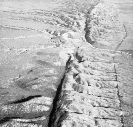
A fault is defined as a crack or fracture in Earth's crust along which rock on one side has moved relative to rock on the other. (When no movement has occurred, the fracture is known as a joint). When a fault breaks the planet's surface, it may range in length from a few inches to thousands of miles. The line on Earth's surface defining the fault is known as the fault line or fault trace.
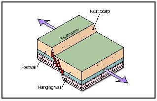
A fault may extend downward from the fault line at least several miles into the crust. The area where crustal blocks meet and move along a fault from the fault line down into the crust is known as the fault plane. The fault plane may be vertical in relation to Earth's surface. If so, the fault is known as a vertical fault. If the fault plane is slanted, the fault is known as an inclined fault. The crustal block that lies beneath the fault plane in an inclined fault is referred to as the footwall. The block that is above or seems to rest on the fault plane is referred to as the hanging wall. These terms do not apply if the fault plane is vertical.
The measure of the angle between Earth's surface and the fault plane is called the fault's dip. Faults are classified according to how steeply they dip and the relative movement of the crustal blocks on either side of a fault. The movement of crustal blocks along a fault has been measured from 0.4 inch (1 centimeter) to 50 feet (15 meters). As mentioned, that movement may be slow or rapid. Slow, continuous movement is known as fault creep. Some faults creep from 0.5 inch (1.3 centimeters) to 4 inches (10 inches) a year.
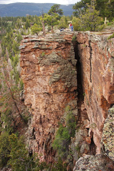
Normal faults occur when underground pressure causes the crust to stretch or pull apart. When this happens, the hanging-wall block (the one above the fault plane) drops down relative to the footwall block. Most normal faults have dips of about 60 degrees. The resulting steep-sided ledge or cliff created at the top of the footwall block is called a fault scarp.
Fault: Words to Know
- Asthenosphere:
- The section of the mantle immediately beneath the lithosphere that is composed of partially melted rock.
- Convection current:
- The circular movement of a gas or liquid between hot and cold areas.
- Crust:
- The thin, solid outermost layer of Earth.
- Dip:
- The measured angle from the horizontal plane (Earth's surface) to a fault plane or bed of rock.
- Fault creep:
- The slow, continuous movement of crustal blocks along a fault.
- Fault line:
- The line on Earth's surface defining a fault; also known as a fault trace.
- Fault plane:
- The area where crustal blocks meet and move along a fault from the fault line down into the crust.
- Fault scarp:
- A steep-sided ledge or cliff generated as a result of fault movement.
- Fault system:
- A network of connected faults.
- Footwall:
- The crustal block that lies beneath an inclined fault plane.
- Graben:
- A block of Earth's crust dropped downward between faults.
- Hanging wall:
- The crustal block that lies above an inclined fault plane.
- Horst:
- A block of Earth's crust forced upward between faults.
- Lithosphere:
- The rigid uppermost section of the mantle combined with the crust.
- Mantle:
- The thick, dense layer of rock that lies beneath Earth's crust.
- Plates:
- Large sections of Earth's lithosphere that are separated by deep fault zones.
- Plate tectonics:
- The geologic theory that Earth's crust is composed of rigid plates that "float" toward or away from each other, either directly or indirectly, shifting continents, forming mountains and new ocean crust, and stimulating volcanic eruptions.
- Strike:
- The compass direction of a fault line.
Normal faults usually occur in elevated regions such as plateaus. They are not often found singly in a landscape; typically, they occur in multiple arrangements, often in pairs of parallel faults. When movement

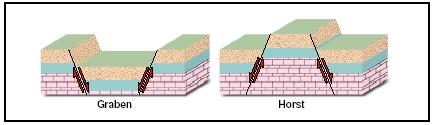
takes place between parallel normal faults whose fault planes are angled downward toward each other (such as \ /), a crustal block may drop down between them. This down-dropped block, which forms a valley between the opposing footwall blocks, is called a graben (pronounced GRAH-bin). If the fault planes of the parallel faults are angled downward away from each other (such as / \), a crustal block between them may be elevated. This uplifted block is called a horst. A large horst that is lifted high can form a fault-block mountain. (For further information on faultblock mountains, see the Mountain chapter.) A series of uplifted and down-dropped blocks across a landscape is called a horst and graben structure. This feature is common in the western United States and northern Mexico.
In contrast, reverse faults occur when underground pressure causes the crust to compress, pushing blocks together. As two blocks are pushed together at a fault, the hanging-wall block is pushed up and over the footwall block. A fault scarp is created, but it takes the form of an overhanging ledge.
A special type of reverse fault is called a thrust fault (sometimes also called an overthrust fault). The fault plane of a thrust fault lies at a low angle to Earth's surface. This angle is less than 30 degrees. Because the angle is so low, the hanging-wall block is thrust up and over the footwall block. The movement is mainly horizontal as the hanging-wall block travels over the footwall block, sometimes for thousands of feet.
These previous faults are all categorized as dip-slip faults because the movement of the fault blocks is up or down along the fault plane. If the
movement is horizontal, with the two fault blocks scraping along side-by-side, the fault is known as a strike-slip fault (sometimes also known as a transcurrent or transverse fault). Strike is the compass direction—north, south, east, west—of the fault line or trace. The fault plane in a strike-slip fault is vertical or nearly vertical. There is little or no fault scarp created along this type of fault.
Strike-slip faults are classified according to the direction of motion of the blocks on either side of the fault. If the block on the opposite side of a strike-slip fault has moved to the left, it is a left-lateral strike-slip fault. If it has moved to the right, it is a right-lateral strike-slip fault. The relative motion, left or right, is the same regardless on which block an observer stands. The famous San Andreas Fault in California is a right-lateral strike-slip fault. Land west of the fault is edging northwest; land east is edging southeast.
In some faults, the movement is neither purely vertical nor horizontal, but a combination of the two. In instances where a fault has both normal and strike-slip movement or reverse and strike-slip movement, it is known as an oblique-slip fault. Although this type of fault is not unusual, it is far less common than normal, reverse, or strike-slip faults.
Forces and changes: Construction and destruction
Any rock subjected to intense stress or pressure over time will deform. At higher temperatures and pressures, rock will soften and bend. Geologists call this ductile deformation. At lower temperatures and pressures, however, rock will break or fracture instead of bending. This type of deformation, called brittle deformation, happens to rock in the upper part of Earth's crust. Faults are a clear example of brittle deformation.
The stress that is continually acting on and deforming Earth's surface may be in different forms: tensional stress, which stretches or pulls rock; compressional stress, which squeezes and squashes rock; and shear stress, which changes the shape of rock by causing adjacent parts to slide past one another. All of these stresses are directly related to events occurring deep within the planet. Earth's internal processes, from the core to the crust, have put the surface of the planet in motion, constantly changing its shape.
From the core to the crust
Geologists divide the surface and the interior of Earth into layers. At the very center of the planet is the core. It begins at a depth of about 1,800 miles (2.900 kilometers) beneath the surface and extends to a depth of 3,960 miles (6,370 kilometers). The core is composed of the metal elements iron and nickel, and it has a solid inner portion and a liquid outer portion. Temperatures in the core are estimated to exceed 9,900°F (5,482°C).
Blindly Faulting Los Angeles
In 1999, geologists mapped for the first time a major fault located directly beneath the city of Los Angeles, California. Named the Puente Hills Fault, it is a blind thrust fault, a type of thrust fault that does not break Earth's surface. This makes it difficult to identify. Comprised of three sections, it runs for nearly 25 miles (40 kilometers) under downtown Los Angeles, through Santa Fe Springs, and into the Coyote Hills of northern Orange County. The fault is approximately 12.5 miles (20 kilometers) wide. It is located about 2 miles (3.2 kilometers) beneath the surface in the center of Los Angeles, then dips to 10 miles (16 kilometers) underground as it continues northward. The entire fault system covers an area of roughly 250 square miles (650 square kilometers).
In the spring of 2003, geologists released a study reporting that the fault is capable of generating major earthquakes. They estimated that the fault has been responsible for some of the most severe earthquakes to strike southern California in the last 11,000 years. They also believed that the fault was responsible for the 1987 earthquake that hit near the city of Whittier, located about 12 miles (19 kilometers) from the center of downtown Los Angeles. Although a major earthquake along the fault will probably occur only once every 2,000 years, geologists believe many of the buildings in downtown Los Angeles will not be able to withstand such an earthquake when it comes.
Above the core lies the thick mantle, which forms the main bulk of the planet's interior. Above the mantle lies the brittle crust, the thin shell of rock that covers Earth. The upper portion of the mantle is rigid. Geologists call the combination of this section of the mantle the overlying crust and the lithosphere (pronounced LITH-uh-sfeer). The lithosphere measures roughly 60 miles (100 kilometers) thick. The part of the mantle immediately beneath the lithosphere is called the asthenosphere (pronounced as-THEN-uh-sfeer). This layer is composed of partially melted rock that has the consistency of putty and extends to a depth of about 155 miles (250 kilometers).
The driving force in Earth's interior
The heat energy generated in the core is extreme. Earth's interior would melt if this energy were not released in some manner. Much like the circulating currents produced in a pot of boiling liquid on a hot stove, this energy is transported to the surface of the planet through currents called convection currents.
When a liquid in a pot begins to boil, it turns over and over. Liquid heated at the bottom of the pot rises to the surface because heating has caused it to expand and become less dense (lighter). Once at the surface, the heated liquid cools and becomes dense (heavier) once more. It then sinks back down to the bottom to become reheated. This continuous motion of heated material rising, cooling, and sinking forms the circular currents known as convection currents.
Similarly, when mantle rocks near the core are heated, they become less dense than the cooler, upper mantle rocks. These heated rocks then slowly rise through the mantle. When they reach the lithosphere, the heated rocks move along the base of the lithosphere, losing heat. Cooling and becoming denser, they then sink back toward the core, only to be heated once again. Scientists estimate that convection currents move mantle rock only an inch or two a year. It takes about 200 million years for heated rock to make a circular trip from the core to the lithosphere and back again.
Plate tectonics and faults
The slowly moving convection currents are able to release their heat energy near the surface of the planet because the lithosphere is broken into many pieces called tectonic or crustal plates. These plates, which vary in size and shape, "float" on the soft, semi-molten (melted) asthenosphere. As the convection currents move under the lithosphere, they exert dragging forces on the rigid tectonic plates above them. This causes the plates to move. Fitting together like pieces in a jigsaw puzzle, the plates are in constant contact with each other. Because they are interconnected, no single plate can move without affecting others. The movement or activity of one plate can influence another plate located thousands of miles away. The scientific theory explaining plates and their movements and interactions is called plate tectonics (a hypothesis is an educated guess; a theory is a principle supported by extensive scientific evidence and testing).
In general, tectonic plates inch their way across the surface of Earth at a rate no faster than human fingernails grow, roughly 2 inches (5 centimeters)
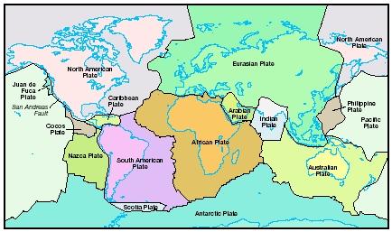
per year. As they move, the plates slide along each other (transform), move into each other (converge), or move away from each other (diverge). Plate margins are the boundaries or areas where the plates meet and interact.
The stresses that produce faulting are usually related to movements along plate margins. Although associated mainly with plate margins, faults can occur anywhere on Earth where the crust is weak. Normal faults are common in regions where the crust is being stretched and thinned as a result of plates diverging. Reverse faults are common in regions where the crust is being compressed and thickened as a result of plates converging. Thrust faults are even more common at convergent plate margins, where plates are moving toward one another, compressing, and often forming high mountains. Strike-slip faults are formed where unequal pressure causes rock sections to slip past each other. Major strike-slip faults occur between plates that are transforming. These special strike-slip plates are known as transform faults.
Spotlight on famous forms
Denali fault system, Alaska
Denali (pronounced de-NAHL-ee) is the name given by the Athabascan-speaking native people of Alaska to the mountain known as Mount McKinley, the highest mountain in North America at 20,320 feet
(6,194 meters). Translated, it means "the Great One." Denali is also the name of a great fault system (a network of connected faults) that extends for about 750 miles (1,200 kilometers) from southeast to southcentral Alaska. Predominantly composed of right-lateral strike-slip faults, Denali is one of the longest strike-slip fault systems in the world.
The Denali Fault marks the boundary where the Pacific Plate and the North American Plate meet and interact. Land south of the fault moves westward, and land north of the fault moves eastward. Geologists estimate that the two sides on the fault have slipped roughly 240 miles (386 kilometers) over the last 60 million years. On average, the plates move about 0.4 inch (1 centimeter) a year along the fault.
At times during the Denali Fault's history, the plates along it have locked up. Subsequent pressure builds up until it is finally released in an earthquake. This is what occurred on November 2, 2002, when an earthquake struck the fault about 90 miles (145 kilometers) south of Fairbanks, Alaska. One of the largest ever recorded in the United States, the earthquake measured 7.9 on the Richter scale (a scale developed by American seismologist Charles Richter to describe the amount of energy released by an earthquake). The earthquake ruptured 155 miles (260 kilometers) of the fault. Movement on the fault caused ground north of the fault to move eastward up to 26 feet (8 meters) relative to ground south of the fault.
New Madrid fault system, Central United States
The New Madrid fault system is a series of faults beneath the continental crust in the central United States. The system exists in the middle of the North American plate where tensional stress created a weak spot known as the Reelfoot rift. Called an intraplate fault system, it is a type of fault system that is still not clearly understood by geologists.
The faults along the system—normal, reverse, and strike-slip—lie 10 to 12 miles (16 to 19 kilometers) beneath Earth's surface. They create no fault lines. The New Madrid fault system extends at least 150 miles (240 kilometers) from Cairo, Illinois, to Marked Tree, Arkansas. It runs beneath the lines of five states: Illinois, Kentucky, Missouri, Tennessee, and Arkansas. It runs beneath the Mississippi River in three areas and the Ohio River in two areas. Movement along the system ranges from 1.5 to 2.8 inches (4 to 7 centimeters) a year.
More earthquakes occur in the area of the New Madrid fault system than in any other area of the United States east of the Rocky Mountains. More than 200 earthquakes are recorded on the system each year, but the vast majority of those cannot be felt. Only about 8 to 10 earthquakes a year are large enough to be felt (measuring 3.0 or more on the Richter scale).
In the winter of 1811–1812, three earthquakes centered on the New Madrid fault system were felt across the continent, from Canada to the Gulf of Mexico, and from the Rocky Mountains to the Atlantic coast. Present-day geologists estimate the largest of the earthquakes measured 8.8 on the Richter scale. The effects were widespread and severe. The most intense earthquake altered the course of the Mississippi River and created a depression in northwest Tennessee that filled with water to become Reelfoot Lake. Aftershocks (earthquake tremors that occur after the main shock) were felt around the region for a year afterward.
San Andreas Fault, California
The well-known San Andreas Fault in California is perhaps the most-studied fault in the world. It is the main fault in an intricate fault system; many smaller faults branch from and join the larger fault. The fault system is located along almost the entire Pacific coast of California, extending for more than 800 miles (1,287 kilometers). Its fault plane reaches down at least 10 miles (16 kilometers) into Earth's crust. Its fault line is a zone of crushed and broken rock that ranges from a few hundred feet to 1 mile (1.6 kilometers) wide.
A right-lateral strike-slip fault, the San Andreas Fault represents the boundary where the North American Plate and the Pacific Plate meet. Along the fault, the two plates scrape against each other as the North American Plate slips to the southeast and the Pacific Plate slips to the northwest. The rate of movement along the fault is about 0.8 to 1.4 inches (2 to 3.5 centimeters) a year. Because it is situated between plates that are transforming, the San Andreas Fault is also considered a transform fault.
Geologists believe the San Andreas Fault came into existence about 15 to 20 million years ago. They estimate that the total movement along the fault since that time has been at least 350 miles (563 kilometers). Thousands of earthquakes, most of which are too small to be felt, occur along the fault regularly. Over the last 1,500 years, large earthquakes along the fault have occurred every 150 years or so. The last recorded large earthquake on the southern portion of the fault took place in 1857. In 1906, a devastating earthquake occurred in the San Francisco region. The plates, which had been locked along the fault, ruptured and tore the ground apart along a 290-mile (467-kilometer) stretch. The ground west of the fault shifted northward as much as 21 feet (6.4 meters) in places.
For More Information
Books
Collier, Michael. A Land in Motion: California's San Andreas Fault . Berkeley, CA: University of California Press, 1999.
Harden, Deborah R. California Geology . Englewood Cliffs, NJ: Prentice Hall, 1997.
Knox, Ray, and David Stewart. The New Madrid Fault Finders Guide . Marble Hill, MO: Gutenberg-Richter Publications, 1995.
Web Sites
"Fault Motion." Incorporated Research Institutions for Seismology . http://www.iris.edu/gifs/animations/faults.htm (accessed on September 1, 2003).
"Faults." Plate Tectonics . http://www.platetectonics.com/book/page_15.asp (accessed on September 1, 2003).
"Hayward Fault." The Berkeley Seismological Laboratory . http://www.seismo.berkeley.edu/seismo/hayward/ (accessed on September 1, 2003).
Mustoe, M. Every Place Has Its Faults! http://www.tinynet.com/faults.html (accessed on September 1, 2003).
"The New Madrid Fault Zone." The Arkansas Center for Earthquake Education and Technology Transfer . http://quake.ualr.edu/public/nmfz.htm (accessed on May 5, 2003).
Schulz, Sandra S. and Robert E. Wallace. "The San Andreas Fault." USGS . http://pubs.usgs.gov/gip/earthq3/safaultgip.html (accessed on September 1, 2003).
my name is Tyikesha Ashford
Thank you
Chris Rockwell
Thank you