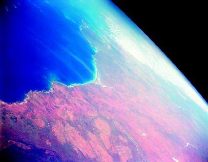
Ocean basin

The features of continental landscapes are mirrored by similar features on the ocean basins. Plateaus, plains, valleys, rolling hills, and volcanic cones and mountains are found beneath the waters of the oceans, just as they are on dry land. Yet the largest underwater mountains are higher than those on the continents, and underwater plains are flatter and more extensive than their dry counterparts. These "oceanscapes," at one time unseen and unknown, may resemble familiar landscapes, but on a much grander scale.
The shape of the land
Ocean basins are that part of Earth's surface that extends seaward from the continental margins (the submerged outer edges of continents, each composed of a continental shelf and a continental slope). Basins lie at an average water depth of about 12,450 feet (3,795 meters). From there they drop steeply down into the deepest trenches. The oceans and seas of the planet form a layer of water that covers approximately 71 percent of Earth's surface. Ocean basins occupy more than 76 percent of the total ocean area.
Many sources include the continental margins as part of the ocean basins, but the margins are the drowned edges of the continents. They are part of the same crust (thin, solid outermost layer of Earth) that forms the continents. The transition between continental crust and oceanic crust occurs in the continental slope. Continental crust is composed mostly of granite, whereas oceanic crust is mostly basalt. Although they differ in composition, both are types of igneous rock that forms when magma cools and solidifies. Granite forms when magma with a high silica content cools slowly deep beneath Earth's surface; basalt forms when magma with a low silica content cools quickly outside of or very near Earth's surface. (For
further information on continental margins, see the Continental margin chapter.)
By ocean basins, this discussion is referring to what may be termed the deep-ocean basins: those areas of the ocean floor lying more than 10,500 feet (3,200 meters) beneath the surface of the oceans. The four main ocean basins are those of the Pacific, Atlantic, Indian, and Arctic Oceans. The Pacific Ocean, which occupies about one-third of Earth's surface, has the largest basin. Its basin also has the greatest average depth at approximately 14,000 feet (4,300 meters). The Atlantic Ocean basin is half the size of that of the Pacific Ocean and is not quite as deep, averaging about 12,000 feet (3,660 meters). While slightly smaller in size than the Atlantic Ocean basin, the Indian Ocean basin sits at a lower average depth, 12,750 feet (3,885 meters). The Arctic Ocean basin is less than 10 percent the size of the Pacific Ocean basin and lies at an average depth of 3,900 feet (1,190 meters).
All ocean basins contain certain primary features: mid-ocean ridges, abyssal (pronounced ah-BISS-ul) plains, trenches, and seamounts.
Perhaps the most impressive features found on all ocean basins are long, continuous volcanic mountain ranges called mid-ocean ridges. These elevated ridges mark the area where sections of oceanic crust are pulling apart from each other. As they do, hot magma (liquid rock) emerges from beneath the crust and seeps forth as lava to fill the crack continuously created by the separation. The lava cools and attaches to the trailing edge of each section, forming new ocean floor crust in a process known as seafloor spreading. Additional lava is deposited by the thousands of volcanoes that periodically erupt along the ridges.
The large depression that is created between the spreading sections is known as a rift valley. Mid-ocean ridges are divided into three groups depending on their spreading rates: slow, medium, and fast. Ridges that spread slowly, from 0.4 to 2 inches (1 to 5 centimeters) per year, have a wide and deep central rift valley. The valley may be 6 miles (10 kilometers) wide and 2 miles (3 kilometers) deep below the crests, or tops, of the ridges that surround it on either side. Ridges that are classified as medium spread at a rate of 2 to 4 inches (5 to 10 centimeters) per year. The valleys of these ridges may be up to 3 miles (5 kilometers) across and range in depth from 165 to 655 feet (50 to 200 meters). Finally, fast-spreading ridges open up at a rate of 4 to 8 inches (10 to 20 centimeters) per year. Their rift valleys are much smoother in appearance. On average, these small valleys are only 330 feet (100 meters) wide and 33 to 66 feet (10 to 20 meters) deep.
In most locations, mid-ocean ridges are 6,500 feet (1,980 meters) or more below the surface of the oceans. In a few places, however, they actually extend above sea level and form islands. Iceland (in the North Atlantic), the Azores (west of the coast of Portugal), and Tristan de Cunha (in the south Atlantic midway between southern Africa and South America) are examples of such islands.
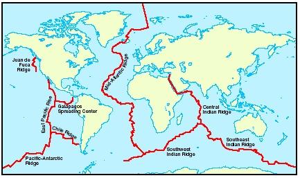
The most-studied mid-ocean ridge in the world is the Mid-Atlantic Ridge. It begins at the tip of Greenland and runs down the center of the Atlantic Ocean between the Americas on the west and Europe and Africa on the east. It ends its course at the southern tip of the African continent. At that point, the ridge continues around the eastern edge of Africa as the Southwest Indian Ridge. That ridge then divides near the center of the Indian Ocean basin into the Central Indian Ridge that runs north into the African continent and the Southeast Indian Ridge that runs east below the Australian continent. The ridge continues eastward along the southern portion of the Pacific Ocean basin as the Pacific Antarctic Ridge. It eventually heads northward along the western coastline of South and Central America as the East Pacific Rise.
These mid-ocean ridges combine to form a global undersea mountain system known as the mid-ocean ridge system. Extending more than 40,000 miles (64,000 kilometers), it is the longest topographic or surface feature on Earth. Snaking its way between the continents, the ridge system encircles the planet like the seams on a baseball. Whereas the seams form a continuous loop, the mid-ocean ridge system is offset in many places. The offsets are called fracture zones. These breaks in the ridge line are caused by faults, cracks or fractures in Earth's crust along which rock on one side has moved relative to rock on the other. Ocean crust on either side of a fault in a fracture zone slides in opposite directions. This helps relieve tension created when different sections of a mid-ocean ridge spread at different rates. The faults form deep, linear gouges almost perpendicular to the ridges. Crust in a fracture zone looks like it has been sliced up by a giant knife. The largest fracture zone occurs along the Mid-Atlantic Ridge, offsetting it by 590 miles (950 kilometers).
The relatively flat areas of ocean basins between continental margins and mid-ocean ridges are called abyssal plains. They are generally found at depths of 13,000 to 16,000 feet (3,960 to 4,875 meters). Likely the most level places on Earth, they are far flatter than any plain on dry land. They have gentle slopes of less than 1 foot (0.3 meter) of elevation difference for each 1,000 feet (305 meters) of distance.
The flatness of abyssal plains is due to an accumulation of layers of sediments formed from the remains of marine life and rock debris such as gravel, sand, silt, and clay. Much of this rock debris has been washed off the surface of the continents for hundreds of thousands of years. It is carried down continental slopes by turbidity currents, turbulent mixtures of water and sediment. Pulled by gravity, these currents may surge downward like an avalanche at up to 50 miles (80 kilometers) per hour. When the currents reach the ocean basin, they slow and the sediment they carry falls on the abyssal plains. In many areas, these sediment layers measure up to 3 miles (5 kilometers) thick. The sediments cover many of the irregularities that may exist in the basaltic rock of the ocean floor. In places where the layers of sediment are thinner, gently sloping hills may rise from the abyssal plains to heights less than 3,280 feet (1,000 meters). Known as abyssal hills, these low, oval-shaped hills are typically volcanic in origin.
The deepest parts of ocean basins are trenches, which may descend over 36,000 feet (11,000 meters) beneath the surface of an ocean. These long, narrow, canyonlike structures are formed where sections of oceanic crust are moving and sliding under sections of continental crust. Thus, trenches are often found parallel to continental margins and the seaward
Ocean basin: Words to Know
- Abyssal hill:
- A gently sloping, small hill, typically of volcanic origin, found on an abyssal plain.
- Abyssal plain:
- The relatively flat area of an ocean basin between a continental margin and a mid-ocean ridge.
- Asthenosphere:
- The section of the mantle immediately beneath the lithosphere that is composed of partially melted rock.
- Continental drift:
- The hypothesis proposed by Alfred Wegener that the continents are not stationary, but have moved across the surface of Earth over time.
- Continental margin:
- The submerged outer edge of a continent, composed of the continental shelf and the continental slope.
- Convection current:
- The circular movement of a gas or liquid between hot and cold areas.
- Crust:
- The thin, solid outermost layer of Earth.
- Fault:
- A crack or fracture in Earth's crust along which rock on one side has moved relative to rock on the other.
- Fracture zone:
- An area where faults occur at right angles to a main feature, such as a mid-ocean ridge.
- Guyot:
- An undersea, flat-topped seamount.
- Hot spot:
- An area beneath Earth's crust where magma currents rise.
- Lithosphere:
- The rigid uppermost section of the mantle combined with the crust.
- Mantle:
- The thick, dense layer of rock that lies beneath Earth's crust.
- Mid-ocean ridge:
- A long, continuous volcanic mountain range found on the basins of all oceans.
- Paleomagnetism:
- The study of changes in the intensity and direction of Earth's magnetic field through time.
- Plates:
- Large sections of Earth's lithosphere that are separated by deep fault zones.
- Plate tectonics:
- The geologic theory that Earth's crust is composed of rigid plates that "float" toward or away from each other, either directly or indirectly, shifting continents, forming mountains and new ocean crust, and stimulating volcanic eruptions.
- Rift valley:
- The deep central crevice in a mid-ocean ridge; also, a valley or trough formed between two normal faults.
- Seafloor spreading:
- The process by which new oceanic crust is formed by the upwelling of magma at mid-ocean ridges, resulting in the continuous lateral movement of existing oceanic crust.
- Seamount:
- An isolated volcanic mountain that often rises 3,280 feet (1,000 meters) or more above the surrounding ocean floor.
- Subduction zone:
- A region where two plates come together and the edge of one plate slides beneath the other.
- Trench:
- A long, deep, narrow depression on the ocean basin with relatively steep sides.
- Turbidity current:
- A turbulent mixture of water and sediment that flows down a continental slope under the influence of gravity.
edge of volcanic island arcs like Japan, the Philippines, and the Aleutian Islands. Of the twenty-two trenches that have been identified around the world, eighteen are located in the Pacific Ocean basin, three in the Atlantic Ocean basin, and one in the Indian Ocean basin.
Seamounts are isolated volcanic mountains that often rise 3,280 feet (1,000 meters) or more above the surrounding ocean floor. Sometimes seamounts rise above sea level to create islands. Geologists estimate that there may be as many as 85 million seamounts on the floors of the world's oceans. Seamounts usually form near mid-ocean ridges or above hot spots, areas where magma plumes melt through Earth's crust to form volcanoes. Hot spot plumes may exist for millions of years. As a section of oceanic crust moves over the hot spot, a chain of volcanoes may be produced. The Hawaiian Islands are an example of such activity.
When volcanic activity ceases, a seamount begins to erode and collapse back into an ocean. If wave action and weathering continue long enough while the seamount is still above sea level, its top may be eroded flat. An undersea, flat-topped seamount is called a guyot (pronounced GHEE-oh). These types of seamounts are common in the western Pacific Ocean.
Glomar Challenger
In 1968, the oceanographic drilling and coring vessel Glomar Challenger was launched on a voyage to study the geological evolution of Earth. From its platform, it was possible to lower up to 20,000 feet (6,096 meters) of pipe into the open ocean, bore into the seafloor to a depth of 2,500 feet (762 meters), and then bring up samples (or cores) of the crust beneath the ocean.
During her fifteen years of operation, the Glomar Challenger operated in all the major oceans and seas of the world. For the geologic community, each of her voyages was the equivalent of a moon shot. The core samples the vessel retrieved were from a remote and largely unexplored portion of Earth's surface. From those samples, geologists were able to establish that Alfred Wegener's hypothesis of continental drift was correct. They were also able to prove the theory of seafloor spreading and determine that the oldest oceanic crust was far younger than the oldest continental crust. From samples taken during later voyages, geologists were able to prove that Earth's magnetic poles have reversed themselves over time.
Forces and changes: Construction and destruction
Prior to World War II (1939–45), the floors of the oceans had been a part of Earth that had received little scientific study. During the war, the U.S. military employed geologists to carry out studies of the sea floors to find hiding places that might be used by both friendly and enemy submarines. The studies, which involved measuring the depth of ocean floors, revealed two important surface features on the floors: mid-ocean ridges and trenches. The geologists also made another important discovery. While using an underwater instrument that measured magnetic materials in order to detect submarines, they found alternating magnetic differences on the ocean floors.
Scientists believe the magnetic field that exists around the planet is generated by Earth's core. The very center of the planet, Earth's core begins some 1,800 miles (2,900 kilometers) beneath the planet's surface and extends to a depth of 3,960 miles (6,370 kilometers). Composed of the metal elements iron and nickel, the core has a solid inner portion and a liquid outer portion. As Earth rotates, so does that iron-bearing core, creating the magnetic field that may be detected with a compass.
Puzzled by the magnetic anomalies found on the ocean floors, geologists in the 1950s began to explore the possible reasons through the study of paleomagnetism (pronounced pay-lee-oh-MAG-nuh-ti-zum; the study of changes in the intensity and direction of Earth's magnetic field through geologic time). They discovered that almost all rocks contain some type of magnetic material. After a rock has formed and begins to cool, the grain or grains of magnetic material in the rock become aligned with the polarity (north-south directionality) of Earth's magnetic field at that time. In effect, a permanent record of Earth's magnetic field at the time the rock cooled and solidified is locked into its magnetic grains.
Studying the magnetic properties of rocks from different locations around the planet, geologists found that Earth's magnetic poles appeared to have wandered around the globe for at least the past several million years. Since this seemed unlikely, geologists concluded that the continents themselves must have moved across the surface of the planet, carrying the magnetic rocks with them. This brought new attention to the hypothesis of continental drift. (A hypothesis is an educated guess, while a theory is a principle supported by extensive scientific evidence and testing.)
Continental drift
In 1910, German geophysicist Alfred Wegener (1880–1930) had begun arguing that Earth's continents do not remain in a fixed position on the planet's surface. He believed instead that they are mobile and over vast amounts of time have drifted across the surface. Wegener called his hypothesis continental drift. He based his hypothesis on the idea that the coastlines of several of the world's continents fit remarkably together. From this, he proposed that the continents had once been joined together in one large continental mass. He called this supercontinent Pangaea (pronounced pan-JEE-ah; from the Greek words meaning "all lands"). What Wegener lacked, however, was a convincing explanation as to what moved the continents along the surface.
Seafloor spreading
A little more than fifty years after Wegener first proposed his hypothesis, American geologist Harry H. Hess (1906–69) offered up his own hypothesis: seafloor spreading. Hess proposed that mid-ocean ridges were areas where the floors of oceans had split apart and where rocks on either side of the ridges were moving away from each other. At the center of the ridges, lava from below welled up and solidified into new volcanic rock on the ocean floors. Like a giant conveyer belt, the spreading ocean floor carried rock away from the ridges in either direction. The youngest rocks were located along the ridges where new lava rose up. The farther the rocks had moved from the ridges, the older they were.
Within a few years of Hess's proposal, geologists discovered that over short time scales, Earth's magnetic field undergoes polarity reversals (the north magnetic pole becomes the south magnetic pole and vice versa). Although not entirely sure of the reasons, geologists know this occurs every 500,000 years or so. As these magnetic reversals occurred in the past, the changing polarities—normal, reversed, normal, reversed—were recorded in newly forming rocks along mid-ocean ridges. When tied with the idea of seafloor spreading, this helped explain the magnetic differences geologists had found on the ocean floors during World War II.
Combining continental drift and seafloor spreading, geologists were able to develop a unifying theory that helped explain how landforms and other geologic features are created and how Earth's surface changes over time. That revolutionary theory is known as plate tectonics.
Plate tectonics
The processes occurring in Earth, from the core to the crust, have put the surface of the planet in motion, constantly changing its shape. Geologists divide the surface and the interior of Earth into layers. As mentioned, the core is at the very center of the planet. Above the core is the mantle, which extends up to about 31 miles (50 kilometers) below the surface of the planet. The mantle accounts for approximately 80 percent of the volume of Earth. Above the mantle lies the brittle crust, the thin shell of rock that covers Earth.
The upper portion of the mantle is rigid. Geologists combine this section of the mantle with the overlying crust, calling it the lithosphere (pronounced LITH-uh-sfeer). The lithosphere measures roughly 60 miles (100 kilometers) thick. The part of the mantle immediately beneath the lithosphere is called the asthenosphere (pronounced as-THEN-uh-sfeer). This layer is composed of partially melted rock that has the consistency of putty and extends to a depth of about 155 miles (250 kilometers).
The lithosphere is broken into many pieces called tectonic or crustal plates, which vary in size and shape. They are in constant contact with each other, fitting together like pieces in a jigsaw puzzle. They float on the semi-molten asthenosphere, and because they are interconnected, no plate can move without affecting those around it. What causes the plates to move are convection currents, which originate at the base of the mantle where it surrounds the core.
With estimated temperatures in the core exceeding 9,900°F (5,482°C), tremendous heat energy is generated there. If that energy were not released in some manner, the interior of the planet would melt. This is prevented by the convection currents, which carry the energy to the surface of the planet where it is released.
Convection currents act similar to the currents produced in a pot of boiling liquid on a hot stove. When a liquid in a pot begins to boil, it turns over and over. Liquid heated at the bottom of the pot rises to the surface because heating has caused it to expand and become less dense (lighter). Once at the surface, the heated material cools and becomes dense once more. It then sinks back down to the bottom to become reheated. This continuous motion of heated material rising, cooling, and sinking forms the circular-moving convection currents.
Like an enormous stove, the core heats the mantle rock that immediately surrounds it. Expanding and becoming less dense, the heated rock slowly rises through cooler, denser mantle rock above it. When it reaches
Hydrothermal Vents
Hydrothermal vents are cracks in the ocean floor or chimneylike structures extending from the ocean floor generally up to 150 feet (45 meters) high. Some are much higher. They are usually found at mid-ocean ridges where volcanic activity is present. Using deep-sea submersible vessels, scientists first discovered hydrothermal vents in the Pacific Ocean in 1977.
These vents release hot mineral-laden water into the surrounding ocean. Temperature of this fluid is typically around 660°F (350°C). Because of the high pressure exerted by water at ocean floor depths, hydrothermal fluids can exceed 212°F (100°C) without boiling. Often, the fluid released is black due to the presence of very fine sulfide mineral particles that contain iron, copper, zinc, and other metals. As a result, these deep-ocean hot springs are called black smokers.
Hydrothermal vents are surrounded by unusual forms of sea life, including giant clams, tube worms, and unique types of fish. These organisms live off bacteria that thrive on the energy-rich chemical compounds transported by hydrothermal fluids. This is the only environment on Earth supported by a food chain that does not depend on the energy of the Sun or photosynthesis. The energy source is chemical, not solar, and is called chemosynthesis.

the lithosphere, the heated rock moves along the base of the lithosphere, exerting dragging forces on the tectonic plates. This causes the plates to move. In the process, the heated rock begins to lose heat. Cooling and becoming denser, the rock then sinks back toward the core, where it will be heated once more. Scientists estimate that it takes mantle rock 200 million years to make the circular trip from the core to the lithosphere and back again.
On average, a plate inches its way across the surface of Earth at a rate no faster than human fingernails grow, which is roughly 2 inches (5 centimeters) per year. As it moves, a plate can transform or slide along another, converge or move into another, or diverge or move away from another. The boundaries where plates meet and interact are known as plate margins.
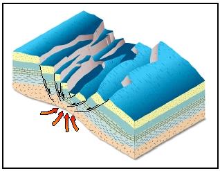
When two continental plates converge, they will crumple up and compress, forming complex mountain ranges. When an oceanic plate converges with a continental plate or another oceanic plate, it will sink beneath the other plate. This is because oceanic crust is made of basalt, which is denser (heavier) than the granite rocks that compose continental crust. The process of one tectonic plate sinking beneath another is known as subduction, and the region where it occurs is known as a subduction zone.
When a tectonic plate subducts beneath another, the leading edge of the subducting plate is pushed farther and farther beneath the surface. When it reaches about 70 miles (112 kilometers) into the mantle, high temperature and pressure melt the rock at the edge of the plate, forming thick, flowing magma. Since it is less dense than the rock that typically surrounds it deep underground, magma tends to rise toward Earth's surface, forcing its way through weakened layers of rock. Most often, magma collects in underground reservoirs called magma chambers where it remains until it is ejected onto the planet's surface through vents called volcanoes. (For further information, see the Volcano chapter.)
Mid-ocean ridges and diverging plates
A mid-ocean ridge is a plate margin where two tectonic plates are diverging. Molten rocks emerge from beneath the crest of the ridge. Geologists estimate that 75 percent of the molten rocks or magma reaching Earth's surface does so through mid-ocean ridges. Coming in contact with seawater, the magma solidifies, forming new ocean crust at the trailing ends of the diverging plates. Rocks solidifying at the ridge crest record the current polarity of Earth's magnetic field.
Fast-spreading ridges have more magma beneath them and more volcanic eruptions occur along the ridges. These ridges seem to spread
somewhat smoothly like hot taffy being pulled apart. Slower-spreading ridges have less magma, and the ocean crust in these areas cracks and breaks as it is pulled apart. The age of rocks in ocean basins increases the farther away they are from ridges. They are also more deeply buried by sediments because those sediments have had a longer time to collect.
Because Earth is in a constant dynamic state, creation and expansion of the crust in one area requires the destruction of the crust elsewhere. On the planet, new crust is formed at diverging plate margins and destroyed at subduction zones. Continental crust may be more than 3 billion years old, but oceanic crust is less than 200 million years old. The recycling of oceanic crust takes place between mid-ocean ridges (where it is created) and huge ocean trenches (where it is destroyed). The Pacific Ocean basin, containing the vast majority of the world's trenches, is currently shrinking as the other ocean basins are expanding.
In a subduction zone, an oceanic plate folds downward, plunging steeply under the adjacent plate and descending into the mantle where it is reabsorbed and returned to a molten state, beginning the cycle all over again. Part of that molten material may rise to the surface again through fractures in the crust. As a consequence, numerous volcanoes are formed parallel to the trenches on the side opposite to that of the subducting oceanic plate. Where the trenches are located in the ocean, as in the Western Pacific, these volcanoes form arcs or chains of volcanic islands. Where the trenches run along the margins of continents, chains of volcanic mountains are formed near the edges of the continents, such as the Andes Mountains in South America.
Spotlight on famous forms
Loihi Seamount, Pacific Ocean
Loihi (pronounced low-EE-hee) is the youngest volcano associated with the Hawaiian Islands chain. It is located about 20 miles (32 kilometers) off the southeastern shore of the island of Hawaii. The basin-shaped summit of the volcano lies 3,178 feet (969 meters) below sea level.
Prior to 1970, geologists believed the seamount was inactive and similar to the other seamounts that surround the Hawaiian Islands. Many of these other seamounts are 80 to 100 million years old. Geologists soon discovered repeated, intense earthquake activity (called swarms) at Loihi. In 1996, the volcano erupted and has been intermittently active since then. If Loihi erupts at rates comparable to other active volcanoes in the Hawaiian Islands, geologists believe it will reach sea level in a few tens of thousands of years.
Mariana Trench, Pacific Ocean
The deepest point on the surface of Earth is found in the Mariana Trench, which is located in the basin of the Pacific Ocean southeast of the Mariana Islands. The trench marks the location where the Pacific Plate is subducting beneath the Philippine Plate. Measuring 1,580 miles (2,542 kilometers) long and 43 miles (69 kilometers) wide, the arc-shaped trench plunges to a maximum depth of 36,201 feet (11,034 meters). The pressure at that great depth is more than 16,000 pounds per square inch (1,125 kilograms per square centimeter). If Mount Everest, the highest point on land, were set into the trench at its deepest point, more than 7,000 feet (2,134 meters) of water would still cover the mountain's peak.
The trench's deepest point, located near its southern extremity, is called the Challenger Deep. It was named after Challenger II , the British naval research vessel that discovered it in 1951. In 1960, the Trieste , a deep-sea research vessel owned by the U.S. Navy, descended to a depth of 35,802 feet (10,912 meters) in the Mariana Trench, setting a record.
Mid-Atlantic Ridge, Atlantic Ocean
The Mid-Atlantic Ridge is a divergent boundary that divides the floor of the Atlantic Ocean. It separates the North American Plate from the Eurasian Plate in its northern section and the South American Plate and the African Plate in its southern section. The submarine mountain range, which extends for about 10,000 miles (16,100 kilometers), is the longest mountain range on Earth. It lies about 10,000 feet (3,048 meters) below water level, except in a few areas where it surfaces as islands.
A slow-spreading mid-ocean ridge, it has a broad and deep central rift valley. The ridge, which ranges in width from 300 to 600 miles (483 to 965 kilometers), features many earthquakes and much volcanic activity. In a 500-mile (805-kilometer) segment of the ridge, geologists recorded a minimum of 481 seamounts.
The Mid-Atlantic Ridge began to develop almost 200 million years ago when the tectonic plates holding the present-day Americas, Europe, and Africa started to move away from each other. The Atlantic Ocean basin formed as a result, and it continues to widen.
For More Information
Books
Erickson, Jon. Marine Geology: Exploring the New Frontiers of the Ocean . Revised ed. New York: Facts on File, 2002.
Seibold, E., and W. H. Berger. The Sea Floor . Third ed. New York: Springer Verlag, 1996.
Web Sites
"Deep Ocean Basins." COAST Resource Guide . http://www.coast-nopp.org/visualization_modules/physical_chemical/basin_coastal_morphology/principal_features/deep_ocean/basins.html (accessed on August 4, 2003).
"Harry Hammond Hess: Spreading the Seafloor." U.S. Geological Survey . http://pubs.usgs.gov/publications/text/HHH.html (accessed on August 4, 2003).
"Mid-Ocean Ridge." Woods Hole Oceanographic Institute . http://www.divediscover.whoi.edu/infomods/midocean/ (accessed on August 4, 2003).
"Ocean Regions: Ocean Floor-Characteristics." Office of Naval Research . http://www.onr.navy.mil/focus/ocean/regions/oceanfloor1.htm (accessed on August 4, 2003).
"The Sea Floor Spread." Public Broadcasting Service . http://www.pbs.org/wgbh/aso/tryit/tectonics/divergent.html (accessed on August 4, 2003).
"This Dynamic Earth: The Story of Plate Tectonics." U.S. Geological Survey . http://pubs.usgs.gov/publications/text/dynamic.html (accessed on August 4, 2003).
"World Ocean Floors." Platetectonics.com . http://www.platetectonics.com/oceanfloors/index.asp (accessed on August 4, 2003).
I am very greatful to learn because It is very difficult to learn for us.
Very good Website for us.
logically we should find a thick cover of sediments on the crests of the spreading ridges, dating which we should get the age of the oceanic basin (the older sediments should be deeper in the sediment deposits on the top of the crests). however due to water aided erosion the oldest sediments are found near the coasts.
this notes is very useful sir.thank you for your notes sir
Alan Moore