Plateau

Plateaus, known variously as tablelands or flat-topped mountains, are regions elevated thousands of feet above their surroundings. They are found on continents around the world, in countries ranging from Algeria to Mexico, from Mongolia to Zimbabwe. In Antarctica, which has a greater average elevation than any other continent, most of the land outside of the mountain ranges can be considered plateaus. Covered by thick ice, many of these areas have no names.
Some plateaus around the world exist at such great heights that their climate is harsh and living conditions are bleak. Others, at much lower elevations, offer more favorable conditions. The terrain of some plateaus is unbroken and flat. The terrain of many others has been eroded away by water and wind over millions of years to create distinct and unusual landforms. As such, many plateaus are landforms filled with landforms.
The shape of the land
By definition, a plateau is a relatively level, large expanse of land that rises some 1,500 feet (457 meters) or more above its surroundings and has at least one steep side. A plateau may cover an area as small as several square miles or as large as half the size of the lower forty-eight United States. Some plateaus formed as a result of geologic uplift, or the slow upward movement of large parts of stable areas of Earth's crust. Others lie between mountains, formed in response to the collision of sections of Earth's crust. Still others formed as a result of many lava flows that spread out over hundreds of thousands of square miles, building up the land surface. These latter plateaus are known as lava or basalt plateaus (basalt is the dark, dense volcanic rock that forms these particular lava flows). Some plateaus can form simply when the side of a land region is weathered away
through erosion (the gradual wearing away of Earth surface features through the action of wind and water).
Plateaus are widespread, covering about 45 percent of Earth's land surface. In Australia, approximately two-thirds of the land area is covered by the Western Plateau. This plateau continues unbroken across much of the central portion of the country, with only occasional rock outcroppings. Much of the plateau has existed as a landmass for more than 500 million years. About 25 percent of China's total land area may be characterized as plateau. The Tibetan Plateau in China's southwest region is the highest and most extensive plateau in the world.
As with all elevated areas, plateaus are continuously carved by erosion, the gradual wearing away of Earth's surfaces through the action of wind and water. Plateaus that contain rivers also contain canyons that have been cut by the rivers as they have sought to reach the level of the lake or ocean into which they flow. Finding the path of least resistance, a river winds across a plateau's surface, cutting through the rock layers. Over millions of years, a river will erode through and expose the rock layers of a plateau, creating a canyon. (For further information, see the Canyon chapter.)
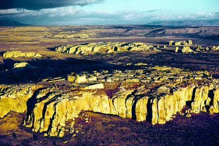
Plateaus may contain thousands of other landforms. Water is the primary sculpting force for most of these. In various forms (rain, groundwater, runoff, and rivers), water has carved mesas, buttes, domes, towers, hoodoos, goblins, temples, and natural rock arches and bridges across plateau landscapes (these landforms also appear elsewhere across the surface of Earth). In general, the relative hardness of the rock making up a plateau determines the type of landforms created there. If the plateau is built on sedimentary rock (rock formed by the accumulation and compression of sediment, which may consist of rock fragments, remains of microscopic organisms, and minerals), its layers will tend to be horizontal, and the landforms on it will have level or flat tops. If the plateau is built on different types of rock of varying hardness, its landforms may be flat or pointed.
Plateau: Words to Know
- Basalt:
- A dark, dense volcanic rock, about 50 percent of which is silica.
- Continental drift:
- The hypothesis proposed by Alfred Wegener that the continents are not stationary, but have moved across the surface of Earth over time.
- Convection current:
- The circular movement of a gas or liquid between hot and cold areas.
- Crust:
- The thin, solid, outermost layer of Earth.
- Erosion:
- The gradual wearing away of Earth surfaces through the action of wind and water.
- Fault:
- A crack or fracture in Earth's crust along which rock on one side has moved relative to rock on the other.
- Lithosphere:
- The rigid uppermost section of the mantle combined with the crust.
- Mantle:
- The thick, dense layer of rock that lies beneath Earth's crust.
- Plates:
- Large sections of Earth's lithosphere that are separated by deep fault zones.
- Plate tectonics:
- The geologic theory that Earth's crust is composed of rigid plates that "float" toward or away from each other, either directly or indirectly, shifting continents, forming mountains and new ocean crust, and stimulating volcanic eruptions.
- Uplift:
- In geology, the slow upward movement of large parts of stable areas of Earth's crust.
Although a plateau is usually considered a single landmass, some plateaus may be composed of numerous smaller plateaus. Such is the case with the Colorado Plateau in the four-corners region (where the boundaries of the four states of Utah, Colorado, Arizona, and New Mexico meet) of the American Southwest. This plateau is actually a series of plateaus separated by north-south trending faults. A fault is a crack or fracture in Earth's crust along which rock on one side has moved relative to rock on the other. Unequal pressure beneath the Colorado Plateau, due to the heat forces contained within Earth, created stress in its surface. This resulted in faults. Separated by the faults, sections of the plateau moved upward by different degrees, creating differences in elevation across the plateau.
Forces and changes: Construction and destruction
The same internal forces of Earth responsible for mountain building, volcanic eruptions, earthquakes, seafloor spreading, and many other topographic features (physical features on the planet's surface) are also responsible for the creation of plateaus. To a lesser degree, so are external forces such as erosion, which helps define the steep sides of a plateau.
Earth is dynamic. As the planet revolves around the Sun and rotates on its axis, its surface and interior are also in motion. Landmasses are in a constant, though slow, state of change. They move, collide, and break apart due to the heat energy stirring beneath the surface of the planet. The giant furnace at Earth's core moves land no more than a few inches per year, but that is enough to have profound consequences on the shape of the landscape.
In the early twentieth century, German geophysicist Alfred Wegener (1880–1930) contended that Earth's continents do not remain in a fixed position on the planet's surface. He believed instead that they are mobile and over vast amounts of time have drifted across the surface. Wegener called his hypothesis continental drift. (A hypothesis is an educated guess, while a theory is a principle supported by extensive scientific evidence and testing.)
Wegener based his hypothesis on the idea that the coastlines of several of the world's continents fit remarkably together. From this, he proposed that the continents had once been joined together in one large continental mass. He called this supercontinent Pangaea (pronounced pan-JEE-ah; from the Greek words meaning "all lands"; see the box on page 255). What Wegener lacked, however, was a convincing explanation as to what moved the continents along the surface. Evidence to support his hypothesis did not come until the early 1960s when geologists developed the theory of plate tectonics.
Earth's layered interior
Geologists divide the surface and the interior of the planet into layers (see the illustration in Volume 1, page 63 of this set). The crust is the thin shell of rock that covers Earth. It is separated into two types: continental crust (which underlies the continents) and oceanic crust (which underlies the oceans). Varying in thickness from 3 to 31 miles (5 to 50 kilometers), the crust is thickest below land and thinnest below the oceans. Underneath the crust lies the mantle, which extends down roughly 1,800 miles (2,900 kilometers) beneath the planet's surface.
The mantle itself is separated into two distinct layers. The uppermost layer is cold and rigid. Geologists combine this section of the mantle with the overlying crust, calling it the lithosphere (pronounced LITH-uhsfeer). The lithosphere measures roughly 60 miles (100 kilometers) thick. The part of the mantle immediately beneath the lithosphere is called the asthenosphere (pronounced as-THEN-uh-sfeer). This layer is composed of partially melted rock that has the consistency of putty and extends to a depth of about 155 miles (250 kilometers).
Pangaea: The Ancient Supercontinent
Throughout Earth's history, fragments of continental crust have floated across the planet's surface, pushed and pulled by plate tectonic motion. At times in the geologic past, these fragments (what we may now call continents) came together to form one large supercontinent, only to be broken apart once again by tectonic forces. The cycle of supercontinent construction and destruction took hundreds of millions of years.
The most recently created supercontinent was Pangaea (pronounced pan-JEE-ah), which came into being about 300 million years ago. Panthalassa, a giant ocean, surrounded it. In just 100 million years, though, Pangaea began to break apart. Tectonic forces created a north-south rift in the super-continent, separating it into two new continents, Laurasia and Gondwanaland. As the new continents separated, the rift filled in with water, eventually becoming the present-day Atlantic Ocean.
Laurasia, composed of the present-day continents of Asia, Europe, and North America (Greenland), occupied the northern hemisphere. Gondwanaland, composed of the present-day continents of Africa, Antarctica, Australia, and South America, occupied the southern hemisphere. The subcontinent of India was also part of Gondwanaland. By 135 million years ago, the breakup of Laurasia and Gondwanaland was underway, leading to the present-day locations of the continents.
The forces that formed Pangaea, then broke it apart, are still at work. North America, South America, and Greenland are all moving westward. Australia, India, and the western part of Africa are all moving northward. Europe and Asia are moving eastward. The Atlantic Ocean is becoming larger, and the Pacific Ocean is becoming smaller. Although impossible to know when, at some point in the future, millions of years from now, the continents may well come together to form yet another super-continent.
Beginning some 1,800 miles (2,900 kilometers) beneath the surface and extending to a depth of 3,960 miles (6,370 kilometers), the very center of the planet, is Earth's core. Composed of the metal elements iron and nickel, the core has a solid inner portion and a liquid outer portion. Scientists estimate that temperatures in the core exceed 9,900°F (5,482°C), creating extreme heat energy. Were this energy not released in some manner, Earth's interior would melt. Circulating currents, called convection currents, carry the energy to the surface of the planet, where it is released. It is the release of this energy underneath the lithosphere that leads to the formation of the major geologic features on the surface of the planet.
Cultural Landforms
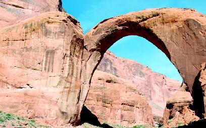
Above the floor of a deep sandstone canyon on the Rainbow Plateau in Utah, surrounded by cliffs that rise 1,000 feet (305 meters), spans the Rainbow Bridge. This natural sandstone bridge, 32 feet (10 meters) thick at its narrowest, arches 290 feet (88 meters) above the streambed of the Bridge Creek. Covering a distance of 270 feet (82 meters), Rainbow Bridge is the largest and most symmetrical natural bridge in the world.
Salmon-pink in color, the bridge is composed entirely of Navajo sandstone. Sandstone is a type of rock made up of grains of sand bonded together by a mineral cement, like calcium carbonate. Water easily dissolves this bond, washing away portions of the sand to form fascinating shapes. Million of years ago, water flowing off nearby Navajo Mountain washed over the area, cutting a canyon in the soft sandstone. As water continued to course through the canyon, it cut a hole in a curve in the canyon's side, eventually leading to the formation of the Rainbow Bridge.
For centuries, the Dine, Hopi, Paiute, and other Native American tribes have held the bridge and the area around it sacred. Present-day Navajo consider it a symbol of rainfall and fertility. In 1910, U.S. President William Howard Taft (1857–1930) designated the bridge and its immediate area a national monument. Currently, Rainbow Bridge is threatened by rising water from nearby Lake Powell Reservoir and by tourism.
Convection currents
Convection is the driving force behind the motion of Earth's interior. The process is similar to what occurs in a pot of boiling water. When the water reaches boiling temperature, normally 212°F (100°C) at sea level, it turns over and over. Heated water at the bottom of the pot rises to the surface because heating has caused it to expand and become less dense (lighter). Once at the surface, the heated material cools and becomes more dense (heavier), then sinks back down to the bottom to be reheated. This continuous motion of heated material rising, cooling, and sinking creates circular currents known as convection currents.
Convection currents form in the planet's interior when rock surrounding the core heats up. Expanding and becoming less dense, the heated rock slowly rises through cooler, denser rock that surrounds it in the mantle. When it reaches the lithosphere, the heated rock moves sideways along the bottom of the lithosphere, losing heat. As the rock cools and becomes denser, it sinks back toward the core, only to be heated once again. Scientists estimate that it takes about 200 million years for heated rock to make a circular trip from the core to the lithosphere and back again.
The slowly moving convection currents are able to release their heat energy near the surface of the planet because the lithosphere is not solid. It is broken into many large slabs or plates that "float" on the soft asthenosphere. In constant contact with each other, these plates fit together like a jigsaw puzzle. When one plate moves, other plates move in response. The pressure exerted by the convection currents underneath the lithosphere causes the plates to move toward or away from each other. Plate tectonics is the scientific theory explaining the plates and their movements and interactions.
Plate tectonics and plateau formation
The plates making up the lithosphere have many different shapes and sizes. There are seven large plates, eight medium-sized plates, and a number of smaller plates. When the plates move, they interact with each other in one of three ways: they converge or move toward each other, they diverge or move away from each other, or they transform or slide past each other. Plate margins are the boundaries or areas where the plates meet and interact.
When two continental (land) plates converge, they crumple up and compress, forming complex mountain ranges and very high plateaus. This is the history of the Tibetan Plateau, created as a result of the collision between the Indian Plate and the Eurasian Plate. While the Himalayan Mountains formed along the edge of the collision, the plateau rose unbroken behind them.
Hoodoos on the Plateau
Hoodoo is a word used to refer to various forms of African-based folk magic and spiritual healing. It is also used to describe the strange and mystical rock shapes found in the western United States and Canada. The most remarkable hoodoos are found in Bryce Canyon in Utah, where erosion has shaped an enormous array of oddly shaped columns of rock tinted with countless subtle colors.
Water, ice, and gravity are the forces that formed Bryce Canyon and its unusual landforms. Yearly, the plateau area of the canyon receives about 19 inches (48 centimeters) of rain, which often falls in fierce thunderstorms. Unable to be absorbed by the normally dry soil, the water washes off in sheets and flash floods, eroding much of the soil and rock in its path. Water in the form of ice, however, is the greater erosive force in the canyon.
In addition to rain, approximately 100 inches (254 centimeters) of snow falls on the canyon per year. Water from the snow runs into cracks and joints in the canyon's rocks, then freezes at night. As water freezes into ice, it expands. The expanding ice in the cracks eventually breaks off portions of the rock, leaving behind a changed rock shape. This process is known as frost wedging.
The composition of the rocks of the hoodoos plays a further part in their bizarre-looking form. The hoodoos are composed of four different types of rock, each of which varies in hardness and erodes at a different rate. As different parts of the hoodoos erode at different times, the rock columns take on their wavy and pockmarked shape.

When a continental plate and an oceanic plate converge, the oceanic plate (which is denser) slides beneath the continental plate in a process known as subduction. As a plate subducts beneath another, its leading edge begins to melt because of high temperature and pressure in the mantle. This forms thick, flowing magma (molten rock beneath the planet's surface). Less dense than the rock that surrounds it deep underground, the magma rises toward Earth's surface, forcing its way through weakened layers of rock. In most instances, the magma collects in underground reservoirs called magma chambers. It remains there until enough pressure builds up to eject it onto the planet's surface through vents called volcanoes. (For further information, see the Volcano chapter.)
Sometimes the magma does not collect in a chamber, but rises beneath a large, stable landmass. Unable to break through any cracks or vents, the magma exerts pressure on the land, causing it to rise upward in one piece. Geologists believe this uplifting process formed the Colorado Plateau about five million years ago.
Lava plateaus
A lava plateau (also called a basalt plateau or flood basalt) is a special type of plateau, formed neither by the collision of continental plates nor by uplift. Instead, this layered plateau is built up over millions of years by lava repeatedly pouring forth through fissures, or long narrow cracks in the ground. (Lava is what magma is called once it reaches Earth's surface.) The cracks could be where tectonic plates are separating or where pressure from magma underneath the crust has created cracks in it.
The most abundant element found in magma is silicon, in the form of the oxide silica. (An oxide is a compound of an element and oxygen. As magma cools, the silica crystallizes to become the mineral quartz.) The amount of silica in magma determines how easily the magma flows. The higher the silica content, the slower the magma (lava) flows. Temperature also affects the flow rate of magma: the higher the magma's temperature, the more readily it flows.
The lava that floods the landscape to create a lava plateau is composed primarily of basalt, a hard, often glassy, black volcanic rock. Basalt has low silica content, and the lava it creates has a high temperature. These two properties combine to produce lava that flows quite rapidly. Erupting from cracks in the ground in thin sheets, basalt lava floods over the landscape, building up to form deposits thousands of feet thick.
The most famous example of a lava plateau in the United States is the Columbia Plateau. It covers most of southern Washington from its border with Idaho west to the Pacific Ocean and south into Oregon. The lava flows that accumulated to form the plateau occurred within the last seventeen million years. More than 40,700 square miles (170,000 square kilometers) of lava covers the plateau. In places, it measures 5,000 feet (1,524 meters) thick.
Spotlight on famous forms
Colorado Plateau, United States
Roughly circular, the Colorado Plateau sprawls across southeastern Utah, northern Arizona, northwestern New Mexico, and western Colorado. It covers a land area of 130,000 square miles (336,700 square kilometers). Only the states of Alaska, California, Montana, and Texas cover a larger area. While tectonic forces thrust the nearby Rocky Mountains into existence some forty to eighty million years ago, the Colorado Plateau remained structurally stable. Originally close to sea level, the plateau was slowly uplifted as a single mass approximately five million years ago.
Elevations on the plateau range from 3,000 to 14,000 feet (915 to 4,270 meters). The average elevation is 5,200 feet (1,585 meters).
Average yearly precipitation on the plateau is about 10 inches (25 centimeters). Because of the plateau's elevation and arid (dry) climate, there is limited plant cover. Erosion by wind and water has resulted in the creation of many dramatic landforms. Rivers have cut thousands of miles of canyons within the plateau. Among these many canyons is the Grand Canyon, sculpted by the Colorado River. The pinnacles and spires of red rock in southwestern Utah's Bryce Canyon are among the most remarkable sights in the country.
Deccan Plateau, India
The Deccan Plateau of west-central India is the oldest and most stable area of land in India. It is a lava plateau that formed over a period of one million or more years. Deccan comes from the Sanskrit work dakshina , meaning "south." The name is applied loosely to all elevated lands of southern India.
The relatively flat plateau covers some 300,000 square miles (770,000 square kilometers), encompassing the states of Andhra Pradesh, Karnataka, Kerala, and Tamil Nadu. Two mountain ranges, the Western and Eastern Ghats, flank it. In spots, the basalt lava flows that created it accumulated to a thickness of 6,000 feet (1,829 meters). In its western regions, the plateau averages about 2,500 feet (762 meters) in elevation; in its eastern parts, it averages 1,000 feet (305 meters). As a result of this difference in elevation from one side to the other, almost all rivers on the plateau flow from west to east and drain into the Bay of Bengal.
Siberian Traps, Russia
The largest volcanic eruptions in Earth's history occurred about 250 million years ago in present-day central Russia. In these eruptions, which scientists believe lasted for 200,000 to 1 million years, basalt lava flowed out of cracks in the ground, forming what is now known as the Siberian Traps. An enormous stretch of rolling land, it covers about 750,000 square miles (1,942,500 square kilometers). Heights on this vast plateau range from 1,600 to 2,300 feet (500 to 700 meters). The lava that created the Siberian Traps would form a layer 10 feet (3 meters) thick if spread out evenly across the planet.
Scientists speculate that the lava on the plateau came from magma that originated some 1,860 miles (3,000 kilometers) beneath Earth's crust. Some scientists have even argued that the rapid volcanic event behind the plateau's formation also brought about the largest extinction of animals in Earth's history. As many as 95 percent of all animal species on the planet were wiped out in an extinction that occurred around the same time period. The scientists point out that the dust and ash released by the lava flows could have blocked out the Sun's light, killing off plant life around the world, a necessary food source for animals. Or great amounts of carbon dioxide released by the flows could have encircled the planet, trapping the Sun's heat and raising temperatures worldwide, killing many life forms.
Tibetan Plateau, Tibet
The Tibetan Plateau is the highest and most widespread plateau in the world. Many believe it is probably the largest and highest area ever to exist in Earth's history. The plateau covers some 888,000 square miles (2.3
million square kilometers), an area roughly half that of the contiguous United States (connected forty-eight states). It is bounded on the north by the deserts of the Tarim and Qaidam (pronounced CHIE-dahm) Basins and on the south by the Himalayan Mountains.
Referred to as the "roof of the world," the plateau has an average elevation over 16,400 feet (5,000 meters). It contains fourteen mountains that rise higher than 26,248 feet (8,000 meters) and hundreds that rise more than 22,967 feet (7,000 meters). The Yarlung Zangbo River, which runs across the plateau, has cut the Yarlung Zangbo Grand Canyon, the deepest canyon in the world. The plateau itself is still geologically active and continues to rise, gaining an average of 0.04 inch (0.1 centimeter) per year in elevation.
Approximately forty to fifty million years ago, the northward-moving Indian Plate rammed into the Eurasian Plate, creating what would eventually become the Himalayan Mountains and the Tibetan Plateau. Geologists have long known that the crust beneath the plateau measures approximately 40 miles (65 kilometers) in depth, roughly twice that of the average continental crust. Only recently have scientists discovered that the plateau is supported by a bed of hot magma (molten rock). Since magma is less dense (lighter) than cold, crustal rock, this bed of magma has helped raise the plateau as a single mass to such a great height.
For More Information
Books
Baars, Donald L. A Traveler's Guide to the Geology of the Colorado Plateau . Salt Lake City: University of Utah Press, 2002.
Ladd, Gary. Landforms, Heart of the Colorado Plateau: The Story Behind the Scenery . Las Vegas, NV: KC Publications, 2001.
Williams, David B. A Naturalist's Guide to Canyon Country . Helena, MT: Falcon Publishing Company, 2001.
Web Sites
"The Colorado Plateau: High, Wide, & Windswept." BLM Environmental Education . http://www.blm.gov/education/colplateau/index.html (accessed on September 2, 2003).
Geology of Tibet Plateau, the Roof of the World . http://www.100gogo.com/geo.htm (accessed on September 2, 2003).
"Lava Plateaus and Flood Basalts." USGS . http://vulcan.wr.usgs.gov/Glossary/LavaPlateaus/description_lava_plateaus.html (accessed on September 2, 2003).
Park Geology Tour: Colorado Plateau . http://www2.nature.nps.gov/grd/tour/cplateau.htm (accessed on September 2, 2003).
because we have our lesson tomorrow about plateau its all here
once again THANK U
best best best pictures
so thank you again because I won the project and its good reading to.I love the Colorado plateaus.
Explaining what is Ecology?